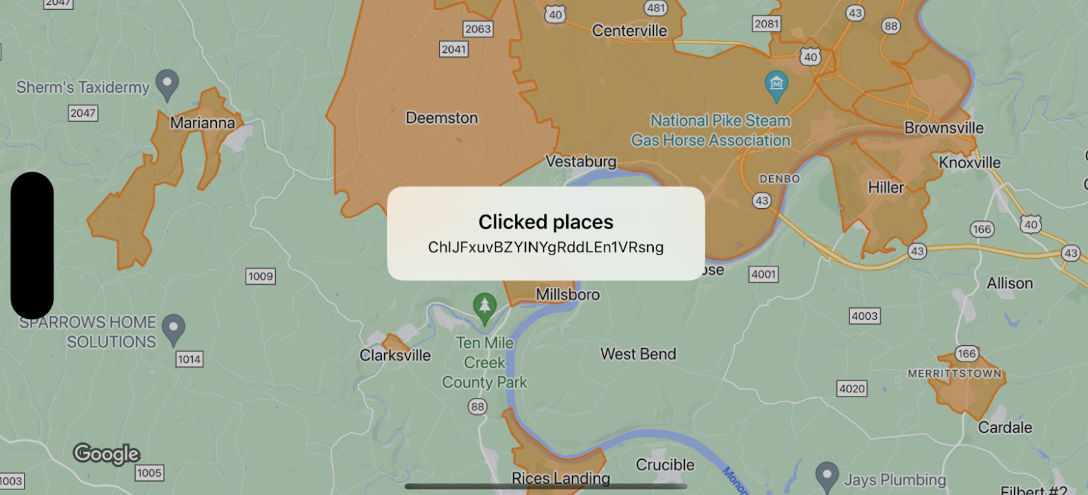
এই উদাহরণটি GMSFeatureTypeLocality জন্য মানচিত্রের সীমানা দেখায় এবং প্রতিনিধি ফাংশন প্রয়োগ করে যা ক্লিক করা বহুভুজকে শৈলী করে। ফলাফল ইভেন্ট ডেটা সহ একটি তথ্য সতর্কতা উইন্ডো প্রদর্শন করে।
[null,null,["2025-08-29 UTC-তে শেষবার আপডেট করা হয়েছে।"],[[["\u003cp\u003eThis documentation demonstrates handling click events on map boundaries, specifically using \u003ccode\u003eGMSFeatureTypeLocality\u003c/code\u003e for the example.\u003c/p\u003e\n"],["\u003cp\u003eWhen a boundary is clicked, an info window appears displaying event data, such as the place IDs of the clicked features.\u003c/p\u003e\n"],["\u003cp\u003eIt's crucial to note that map boundaries need a minimum alpha value for click events to register, ensuring they are tappable.\u003c/p\u003e\n"],["\u003cp\u003eSample code snippets in Swift and Objective-C are provided for implementation guidance on setting up and responding to click events on map boundaries.\u003c/p\u003e\n"]]],["The content demonstrates handling map boundary click events for the `GMSFeatureTypeLocality` feature on iOS. Key actions include setting a style for locality features (orange with 50% opacity fill, orange stroke, width of 2) and implementing a delegate function. This function triggers an alert showing the `placeID` of the features that are clicked. The code examples are shown in both Swift and Objective-C. Note that a minimal alpha value is required for the polygon features to be tappable.\n"],null,["Select platform: [Android](/maps/documentation/android-sdk/dds-boundaries/handle-events \"View this page for the Android platform docs.\") [iOS](/maps/documentation/ios-sdk/dds-boundaries/handle-events \"View this page for the iOS platform docs.\") [JavaScript](/maps/documentation/javascript/dds-boundaries/handle-events \"View this page for the JavaScript platform docs.\")\n\n\u003cbr /\u003e\n\nThis example shows map boundaries for\n[`GMSFeatureTypeLocality`](/maps/documentation/ios-sdk/reference/objc/Constants/GMSFeatureTypeLocality), and implements the\n[delegate](/maps/documentation/ios-sdk/events) function that styles the clicked\npolygon. The result displays an info alert window with the event data.\n\n**Important:** Invisible features don't trigger click events. Polygons must have a minimal alpha value to make them tappable. \n\nSwift \n\n```swift\nclass SampleViewController: UIViewController {\n\n private lazy var mapView: GMSMapView = GMSMapView(frame: .zero, mapID: GMSMapID(identifier: \"YOUR_MAP_ID\"), camera: GMSCameraPosition(latitude: 40, longitude: -80, zoom: 12))\n\n override func loadView() {\n view = mapView\n let style = FeatureStyle(fill: .orange.withAlphaComponent(0.5), stroke: .orange, strokeWidth: 2)\n mapView.featureLayer(of: .locality).style = { _ in style }\n mapView.delegate = self\n }\n}\n\nextension SampleViewController: GMSMapViewDelegate {\n func mapView(_ mapView: GMSMapView, didTap features: [Feature], in featureLayer: FeatureLayer\u003cFeature\u003e, atLocation: CLLocationCoordinate2D) {\n let toast = UIAlertController(title: \"Clicked places\", message: (features.compactMap { ($0 as? PlaceFeature)?.placeID }).joined(separator: \", \"), preferredStyle: .alert)\n present(toast, animated: true, completion: nil)\n }\n}\n```\n\nObjective-C \n\n```objective-c\n@interface SampleViewController: UIViewController \u003cGMSMapViewDelegate\u003e\n@end\n\n@implementation SampleViewController\n- (void)loadView {\n GMSMapView *mapView = [GMSMapView mapWithFrame:CGRectZero mapID:[GMSMapID mapIDWithIdentifier:@\"YOUR_MAP_ID\"] camera:[GMSCameraPosition cameraWithLatitude:40 longitude:-80 zoom:12]];\n mapView.delegete = self;\n\n GMSFeatureStyle *style = [GMSFeatureStyle styleWithFillColor:[[UIColor orangeColor] colorWithAlphaComponent:0.5] strokeColor:[UIColor orangeColor] strokeWidth:2.0];\n [mapView featureLayerOfFeatureType:GMSFeatureTypeLocality].style = ^(GMSPlaceFeature *feature) { return style; };\n\n self.view = mapView;\n}\n\n- (void)mapView:(GMSMapView *)mapView didTapFeatures:(NSArray\u003cid\u003cGMSFeature\u003e\u003e *)features inFeatureLayer:(GMSFeatureLayer *)featureLayer atLocation:(CLLocationCoordinate2D)location {\n NSMutableArray\u003cNSString *\u003e *places = [NSMutableArray array];\n\n for (id\u003cGMSFeature\u003e feature in features) {\n if (![feature isKindOfClass:[GMSPlaceFeature class]]) { continue; }\n NSString *placeID = ((GMSPlaceFeature *)feature).placeID;\n [places addObject:placeID];\n }\n\n UIAlertController *toast = [UIAlertController alertControllerWithTitle:@\"Clicked places\" message:[places componentsJoinedByString:@\", \"] preferredStyle:UIAlertControllerStyleAlert];\n [self presentViewController:toast animated:YES completion:nil];\n}\n```"]]