
การจัดสไตล์ตามข้อมูลที่ขับเคลื่อนโดยขอบเขตช่วยให้คุณเข้าถึงรูปหลายเหลี่ยมของ Google สำหรับขอบเขตการปกครอง ใช้การจัดสไตล์กับรูปหลายเหลี่ยมของขอบเขต และแสดงบนแผนที่ได้
การจัดสไตล์ตามข้อมูลที่ระบุขอบเขตช่วยให้คุณกำหนดเป้าหมายเป็นภูมิภาคตามรหัสสถานที่ และกำหนดการจัดสไตล์ที่กำหนดเองให้กับรูปหลายเหลี่ยมขอบเขตบนแผนที่ได้ องค์ประกอบแต่ละประเภทแสดงถึงประเภทของภูมิภาค โดยคุณเลือกประเภทองค์ประกอบที่จะเปิดใช้เมื่อกำหนดค่ารูปแบบแผนที่ ดูความครอบคลุมของขอบเขตของ Google เพื่อดูความครอบคลุมของขอบเขตในแต่ละประเทศ
ประเภทฟีเจอร์
การจัดสไตล์ตามข้อมูลช่วยให้เข้าถึงขอบเขตของ Google สำหรับประเภทองค์ประกอบที่แสดงถึงเขตบริหาร พื้นที่บริหารจะแบ่งหมวดหมู่ตามฟังก์ชัน เช่น ประเทศ รัฐ ท้องถิ่น และรหัสไปรษณีย์ ประเภทสถานที่จัดเรียงตามระดับการบริหาร ซึ่งโครงสร้างจะแตกต่างกันไปในแต่ละประเทศ ซึ่งได้แก่
GMSFeatureTypeCountry— หน่วยงานทางการเมืองระดับชาติ ซึ่งมักจะเป็นประเภทลําดับสูงสุดGMSFeatureTypeAdministrativeAreaLevel1- บุคคลธรรมดาระดับแรกที่อยู่ต่ำกว่าระดับประเทศ ระดับการปกครองเหล่านี้ในสหรัฐอเมริกาคือรัฐGMSFeatureTypeAdministrativeAreaLevel2— บุคคลธรรมดาระดับที่ 2 ที่อยู่ต่ำกว่าระดับประเทศ ระดับการปกครองเหล่านี้เรียกว่าเขตในสหรัฐอเมริกาGMSFeatureTypeLocality— หน่วยงานทางการเมืองของเมืองหรือเมืองที่รวมตัวกันGMSFeatureTypePostalCode— รหัสไปรษณีย์ที่ใช้ระบุที่อยู่ไปรษณีย์ภายในประเทศGMSFeatureTypeSchoolDistrict— เขตพื้นที่การศึกษา ซึ่งรวมถึงเขตการศึกษาแบบรวม ประถมศึกษา และมัธยมศึกษา
เขตบริหารจะแสดงบนแผนที่เป็นเลเยอร์องค์ประกอบ โดยแต่ละประเภทจะมีเลเยอร์ของตัวเอง ระบบจะเปิดใช้เลเยอร์ฟีเจอร์ตามสไตล์แผนที่ คุณเลือกเลเยอร์องค์ประกอบที่จะเปิดใช้ได้เมื่อตั้งค่าสไตล์แผนที่ในคอนโซล Google Cloud
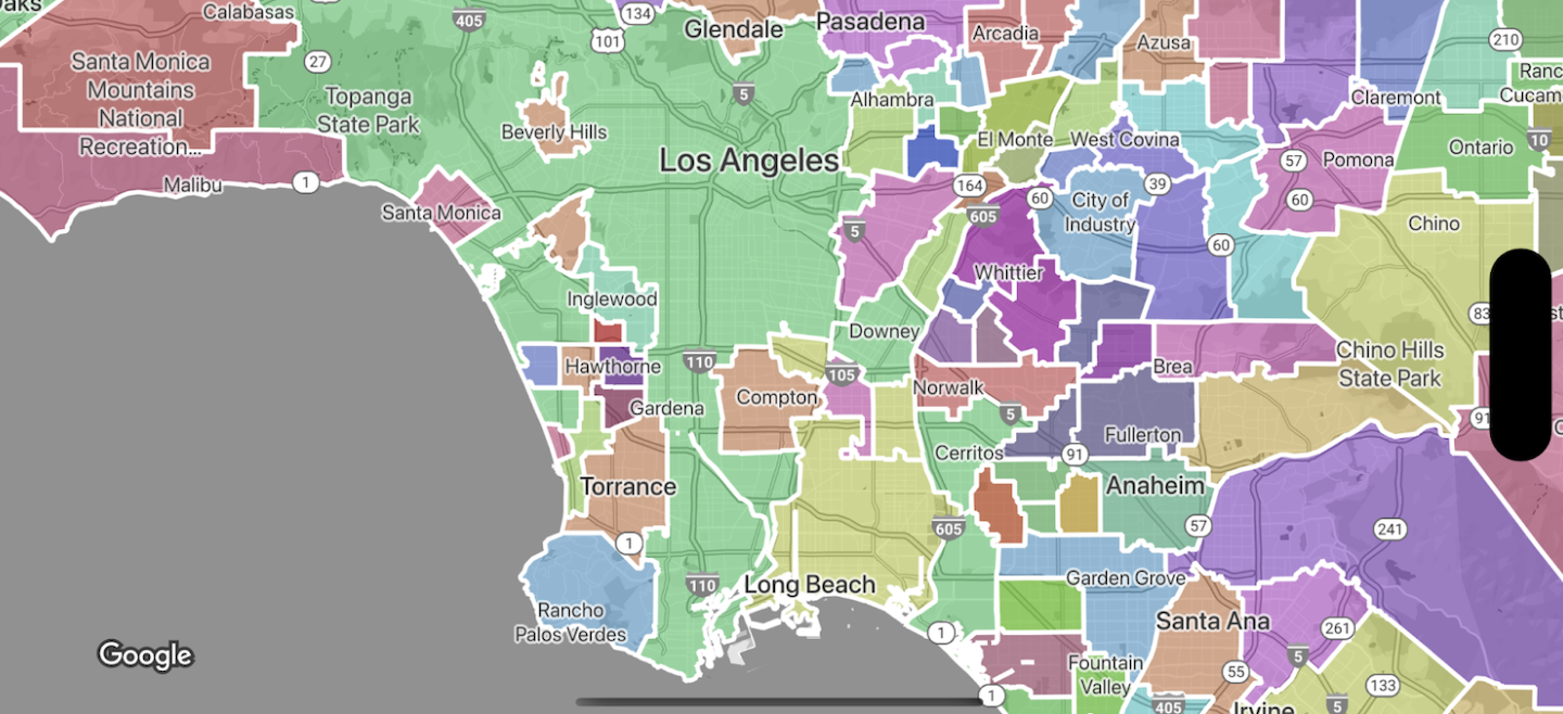
รูปหลายเหลี่ยมขอบเขตของสไตล์
คุณใช้รูปแบบกับรูปหลายเหลี่ยมขอบเขตสำหรับการเติม (สี ความทึบแสง) และเส้นโครงร่าง (สี ความทึบแสง น้ำหนักเส้นโครงร่าง) ได้ ใช้การจัดรูปแบบเพื่อดำเนินการต่อไปนี้
- จัดรูปแบบรูปหลายเหลี่ยมขอบเขตหรือแสดงขอบเขตทั้งหมดของประเภทองค์ประกอบ
- สร้างแผนที่โคโรเพลท
ความครอบคลุมของขอบเขตของ Google แสดงความพร้อมให้บริการของประเภทสถานที่ตามประเทศ