

Làm cho các đối tượng dữ liệu phản hồi sự kiện nhấn và sử dụng sự kiện đó để hiển thị giá trị của một thuộc tính cho đối tượng được nhấn.
Xử lý sự kiện lớp tập dữ liệu
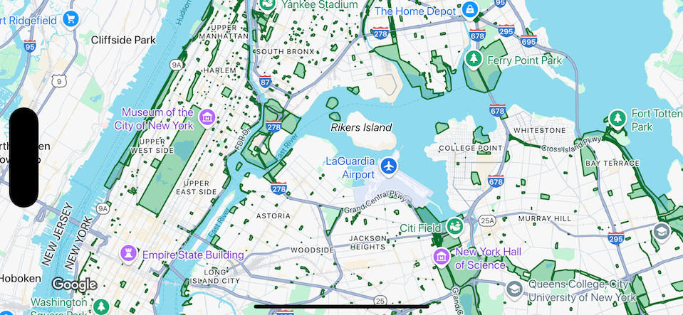
Ví dụ này cho thấy các đối tượng dữ liệu của một tập dữ liệu có mã nhận dạng YOUR_DATASET_ID và triển khai hàm delegate để hiển thị giá trị của một thuộc tính cho đối tượng được nhấn.
Trong ví dụ này, tập dữ liệu cho thấy
các công viên ở Thành phố New York.
Đối với mỗi đối tượng trong tập dữ liệu, tương ứng với một công viên, tập dữ liệu chứa một tên thuộc tính có tên là acres chứa diện tích bề mặt của công viên. Đối với công viên được nhấn, hãy hiển thị giá trị của thuộc tính acres.
Swift
class SampleViewController: UIViewController {

  private lazy var mapView: GMSMapView = {
    let options = GMSMapViewOptions()
    options.mapID = GMSMapID(identifier: "YOUR_MAP_ID")
    options.camera = GMSCameraPosition(latitude: 40.7, longitude: -74, zoom: 12)
    return GMSMapView(options: options)
  }()

  // Set default styles.
  view = mapView
  let style = FeatureStyle(fill: .green.withAlphaComponent(0.5), stroke: .green, strokeWidth: 2)
  mapView.datasetFeatureLayer(of: "YOUR_DATASET_ID").style = { _ in style }
  mapView.delegate = self
}

extension SampleViewController: GMSMapViewDelegate {
  func mapView(_ mapView: GMSMapView, didTap features: [Feature], in featureLayer: FeatureLayer<Feature>, atLocation: CLLocationCoordinate2D) {
    let toast = UIAlertController(title: "Area of park", message: (features.compactMap { ($0 as? DatasetFeature)?.datasetAttributes["acres"] }).joined(separator: ", "), preferredStyle: .alert)
    present(toast, animated: true, completion: nil)
  }
}
Objective-C
@interface SampleViewController: UIViewController <GMSMapViewDelegate>
@end

@implementation SampleViewController
- (void)loadView {
    GMSMapViewOptions *options = [[GMSMapViewOptions alloc] init];
    options.camera = [GMSCameraPosition cameraWithLatitude:40.7 longitude:-74 zoom:12];
    options.mapID = [GMSMapID mapIDWithIdentifier:@"YOUR_MAP_ID"];
    GMSMapView *mapView = [[GMSMapView alloc] initWithOptions:options];
    mapView.delegate = self;

    // Set default styles.
    GMSFeatureStyle *style = [GMSFeatureStyle styleWithFillColor:[[UIColor greenColor] colorWithAlphaComponent:0.5] strokeColor:[UIColor greenColor] strokeWidth:2.0];
    [mapView datasetFeatureLayerOfDatasetID:@"YOUR_DATASET_ID"].style = ^(GMSDatasetFeature *feature) { return style; };

    self.view = mapView;
}

- (void)mapView:(GMSMapView *)mapView didTapFeatures:(NSArray<id<GMSFeature>> *)features inFeatureLayer:(GMSFeatureLayer *)featureLayer atLocation:(CLLocationCoordinate2D)location {
  NSMutableArray<NSString *> *parkAreas = [NSMutableArray array];

  for (id<GMSFeature> feature in features) {
    if (![feature isKindOfClass:[GMSDatasetFeature class]]) { continue; }
    NSString *nameDefinedInDataset = ((GMSDatasetFeature *)feature).datasetAttributes[@"acres"];
    [parkAreas addObject:nameDefinedInDataset];
  }

  UIAlertController *toast = [UIAlertController alertControllerWithTitle:@"Area of park" message:[parkAreas componentsJoinedByString:@", "] preferredStyle:UIAlertControllerStyleAlert];
  [self presentViewController:toast animated:YES completion:nil];
}
@end