Como ocultar elementos do mapa com estilos
Mantenha tudo organizado com as coleções
Salve e categorize o conteúdo com base nas suas preferências.
Selecione a plataforma:
Android
iOS
JavaScript
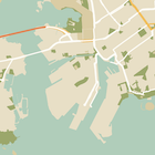
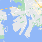
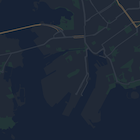
É possível mudar ou ocultar completamente o estilo dos elementos no mapa. Neste exemplo, mostramos como ocultar pontos de interesse (PDIs) comerciais e ícones de transporte público.
Os estilos só funcionam no tipo de mapa kGMSTypeNormal
.
Aplicar estilos ao mapa
Para aplicar estilos de mapa personalizados a um mapa, chame GMSMapStyle(...)
para criar uma instância GMSMapStyle
, transmitindo um URL para um arquivo JSON local ou uma string JSON que contenha definições de estilo. Atribua a instância GMSMapStyle
à propriedade mapStyle
do mapa.
Usar um arquivo JSON
Os exemplos a seguir mostram como chamar GMSMapStyle(...)
e transmitir um URL para um arquivo local:
O exemplo de código a seguir supõe que seu projeto contenha um arquivo chamado
style.json
:
Swift
import GoogleMaps
class MapStyling: UIViewController {
// Set the status bar style to complement night-mode.
override var preferredStatusBarStyle: UIStatusBarStyle {
return .lightContent
}
override func loadView() {
let camera = GMSCameraPosition.camera(withLatitude: -33.86, longitude: 151.20, zoom: 14.0)
let mapView = GMSMapView.map(withFrame: CGRect.zero, camera: camera)
do {
// Set the map style by passing the URL of the local file.
if let styleURL = Bundle.main.url(forResource: "style", withExtension: "json") {
mapView.mapStyle = try GMSMapStyle(contentsOfFileURL: styleURL)
} else {
NSLog("Unable to find style.json")
}
} catch {
NSLog("One or more of the map styles failed to load. \(error)")
}
self.view = mapView
}
}
Objective-C
#import "MapStyling.h"
@import GoogleMaps;
@interface MapStyling ()
@end
@implementation MapStyling
// Set the status bar style to complement night-mode.
- (UIStatusBarStyle)preferredStatusBarStyle {
return UIStatusBarStyleLightContent;
}
- (void)loadView {
GMSCameraPosition *camera = [GMSCameraPosition cameraWithLatitude:-33.86
longitude:151.20
zoom:12];
GMSMapView *mapView = [GMSMapView mapWithFrame:CGRectZero camera:camera];
mapView.myLocationEnabled = YES;
NSBundle *mainBundle = [NSBundle mainBundle];
NSURL *styleUrl = [mainBundle URLForResource:@"style" withExtension:@"json"];
NSError *error;
// Set the map style by passing the URL for style.json.
GMSMapStyle *style = [GMSMapStyle styleWithContentsOfFileURL:styleUrl error:&error];
if (!style) {
NSLog(@"The style definition could not be loaded: %@", error);
}
mapView.mapStyle = style;
self.view = mapView;
}
@end
Para definir as opções de estilo, adicione um novo arquivo ao projeto chamado style.json
e cole a seguinte declaração de estilo JSON para ocultar PDIs comerciais e ícones de transporte público:
Mostre/oculte o JSON.
[
{
"featureType": "poi.business",
"elementType": "all",
"stylers": [
{
"visibility": "off"
}
]
},
{
"featureType": "transit",
"elementType": "labels.icon",
"stylers": [
{
"visibility": "off"
}
]
}
]
Como usar um recurso de string
Os exemplos a seguir mostram como chamar GMSMapStyle()
e transmitir um recurso de string:
Swift
class MapStylingStringResource: UIViewController {
let MapStyle = "JSON_STYLE_GOES_HERE"
// Set the status bar style to complement night-mode.
override var preferredStatusBarStyle: UIStatusBarStyle {
return .lightContent
}
override func loadView() {
let camera = GMSCameraPosition.camera(withLatitude: -33.86, longitude: 151.20, zoom: 14.0)
let mapView = GMSMapView.map(withFrame: CGRect.zero, camera: camera)
do {
// Set the map style by passing a valid JSON string.
mapView.mapStyle = try GMSMapStyle(jsonString: MapStyle)
} catch {
NSLog("One or more of the map styles failed to load. \(error)")
}
self.view = mapView
}
}
Objective-C
@implementation MapStylingStringResource
// Paste the JSON string to use.
static NSString *const kMapStyle = @"JSON_STYLE_GOES_HERE";
// Set the status bar style to complement night-mode.
- (UIStatusBarStyle)preferredStatusBarStyle {
return UIStatusBarStyleLightContent;
}
- (void)loadView {
GMSCameraPosition *camera = [GMSCameraPosition cameraWithLatitude:-33.86
longitude:151.20
zoom:12];
GMSMapView *mapView = [GMSMapView mapWithFrame:CGRectZero camera:camera];
mapView.myLocationEnabled = YES;
NSError *error;
// Set the map style by passing a valid JSON string.
GMSMapStyle *style = [GMSMapStyle styleWithJSONString:kMapStyle error:&error];
if (!style) {
NSLog(@"The style definition could not be loaded: %@", error);
}
mapView.mapStyle = style;
self.view = mapView;
}
@end
A declaração de estilo a seguir oculta PDIs de empresas e ícones de transporte público. Cole a seguinte string de estilo como o valor da variável kMapStyle
:
Mostre/oculte o JSON.
@"["
@" {"
@" \"featureType\": \"poi.business\","
@" \"elementType\": \"all\","
@" \"stylers\": ["
@" {"
@" \"visibility\": \"off\""
@" }"
@" ]"
@" },"
@" {"
@" \"featureType\": \"transit\","
@" \"elementType\": \"labels.icon\","
@" \"stylers\": ["
@" {"
@" \"visibility\": \"off\""
@" }"
@" ]"
@" }"
@"]"
Declarações de estilo JSON
Os mapas estilizados usam dois conceitos para aplicar cores e outras mudanças de estilo:
- Os seletores especificam os componentes geográficos que você pode personalizar no mapa. Por exemplo: vias, parques, corpos d'água e muito mais, bem como as etiquetas. Os seletores incluem recursos e elementos, especificados como propriedades
featureType
e elementType
.
- Os estilizadores são propriedades de cor e visibilidade que você pode aplicar aos elementos do mapa. Eles definem a cor mostrada usando uma combinação de valores de matiz, cor e iluminação/gama.
Consulte a referência de estilo para conferir uma descrição detalhada das opções de estilo JSON.
Use o assistente de estilo da Plataforma Google Maps para gerar rapidamente um objeto de estilo JSON. O SDK do Maps para iOS é compatível com as mesmas declarações de estilo da API Maps JavaScript.
Exemplos de código completos
O repositório ApiDemos (em inglês) no GitHub inclui exemplos que demonstram o uso dos estilos.
Exceto em caso de indicação contrária, o conteúdo desta página é licenciado de acordo com a Licença de atribuição 4.0 do Creative Commons, e as amostras de código são licenciadas de acordo com a Licença Apache 2.0. Para mais detalhes, consulte as políticas do site do Google Developers. Java é uma marca registrada da Oracle e/ou afiliadas.
Última atualização 2025-08-31 UTC.
[null,null,["Última atualização 2025-08-31 UTC."],[[["\u003cp\u003eLearn how to hide map features like business POIs and transit icons using the Google Maps SDK for iOS.\u003c/p\u003e\n"],["\u003cp\u003eApply custom styles by providing a local JSON file or a JSON string containing style definitions to the \u003ccode\u003emapStyle\u003c/code\u003e property of your map.\u003c/p\u003e\n"],["\u003cp\u003eUtilize the \u003ccode\u003efeatureType\u003c/code\u003e and \u003ccode\u003eelementType\u003c/code\u003e properties in your JSON to select the specific map components you want to style.\u003c/p\u003e\n"],["\u003cp\u003eControl the visibility and color of map elements through \u003ccode\u003estylers\u003c/code\u003e in your JSON style declaration.\u003c/p\u003e\n"],["\u003cp\u003eExplore the Maps Platform Styling Wizard for a user-friendly way to generate JSON styling objects for your map.\u003c/p\u003e\n"]]],["To style maps, you can hide features like business POIs and transit icons. Apply styles using `GMSMapStyle`, either with a local JSON file URL or a JSON string. Create a `style.json` file, and use selectors (features and elements) and stylers (visibility) to define map styles. Use the `mapStyle` property on the map to apply styles. Alternatively, you can define a JSON string with the same style options. You can utilize the [Maps Platform Styling Wizard](https://mapstyle.withgoogle.com) for an efficient JSON style object creation.\n"],null,["Select platform: [Android](/maps/documentation/android-sdk/hiding-features \"View this page for the Android platform docs.\") [iOS](/maps/documentation/ios-sdk/hiding-features \"View this page for the iOS platform docs.\") [JavaScript](/maps/documentation/javascript/json-styling-overview \"View this page for the JavaScript platform docs.\")\n\n\u003cbr /\u003e\n\nAs well as changing the style of features on the map, you can also hide them\nentirely. This example shows you how to hide business points of interest (POIs)\nand public transit icons on your map.\n\nStyling works only on the `kGMSTypeNormal` map type.\n\nApplying styles to your map\n\nTo apply custom map styles to a map, call `GMSMapStyle(...)` to create a\n`GMSMapStyle` instance, passing in a URL for a local JSON file, or a JSON\nstring containing style definitions. Assign the `GMSMapStyle` instance to the\n`mapStyle` property of the map.\n\nUsing a JSON file\n\nThe following examples show calling `GMSMapStyle(...)` and passing a URL for a\nlocal file:\n\nThe following code sample assumes your project contains a file named\n`style.json`:\n\n\nSwift \n\n```swift\nimport GoogleMaps\n\nclass MapStyling: UIViewController {\n\n // Set the status bar style to complement night-mode.\n override var preferredStatusBarStyle: UIStatusBarStyle {\n return .lightContent\n }\n\n override func loadView() {\n let camera = GMSCameraPosition.camera(withLatitude: -33.86, longitude: 151.20, zoom: 14.0)\n let mapView = GMSMapView.map(withFrame: CGRect.zero, camera: camera)\n\n do {\n // Set the map style by passing the URL of the local file.\n if let styleURL = Bundle.main.url(forResource: \"style\", withExtension: \"json\") {\n mapView.mapStyle = try GMSMapStyle(contentsOfFileURL: styleURL)\n } else {\n NSLog(\"Unable to find style.json\")\n }\n } catch {\n NSLog(\"One or more of the map styles failed to load. \\(error)\")\n }\n\n self.view = mapView\n }\n}\n \n```\n\nObjective-C \n\n```objective-c\n#import \"MapStyling.h\"\n@import GoogleMaps;\n\n@interface MapStyling ()\n\n@end\n\n@implementation MapStyling\n\n// Set the status bar style to complement night-mode.\n- (UIStatusBarStyle)preferredStatusBarStyle {\n return UIStatusBarStyleLightContent;\n}\n\n- (void)loadView {\n GMSCameraPosition *camera = [GMSCameraPosition cameraWithLatitude:-33.86\n longitude:151.20\n zoom:12];\n GMSMapView *mapView = [GMSMapView mapWithFrame:CGRectZero camera:camera];\n mapView.myLocationEnabled = YES;\n\n NSBundle *mainBundle = [NSBundle mainBundle];\n NSURL *styleUrl = [mainBundle URLForResource:@\"style\" withExtension:@\"json\"];\n NSError *error;\n\n // Set the map style by passing the URL for style.json.\n GMSMapStyle *style = [GMSMapStyle styleWithContentsOfFileURL:styleUrl error:&error];\n\n if (!style) {\n NSLog(@\"The style definition could not be loaded: %@\", error);\n }\n\n mapView.mapStyle = style;\n self.view = mapView;\n}\n\n@end\n \n```\n\n\u003cbr /\u003e\n\nTo define the style options, add a new file to your project named `style.json`,\nand paste the following JSON style declaration to hide business points of\ninterest (POIs) and public transit icons:\nShow/Hide the JSON. \n\n```text\n[\n {\n \"featureType\": \"poi.business\",\n \"elementType\": \"all\",\n \"stylers\": [\n {\n \"visibility\": \"off\"\n }\n ]\n },\n {\n \"featureType\": \"transit\",\n \"elementType\": \"labels.icon\",\n \"stylers\": [\n {\n \"visibility\": \"off\"\n }\n ]\n }\n]\n```\n\nUsing a string resource\n\nThe following examples show calling `GMSMapStyle()` and passing a string\nresource:\n\n\nSwift \n\n```swift\nclass MapStylingStringResource: UIViewController {\n\n let MapStyle = \"JSON_STYLE_GOES_HERE\"\n\n // Set the status bar style to complement night-mode.\n override var preferredStatusBarStyle: UIStatusBarStyle {\n return .lightContent\n }\n\n override func loadView() {\n let camera = GMSCameraPosition.camera(withLatitude: -33.86, longitude: 151.20, zoom: 14.0)\n let mapView = GMSMapView.map(withFrame: CGRect.zero, camera: camera)\n\n do {\n // Set the map style by passing a valid JSON string.\n mapView.mapStyle = try GMSMapStyle(jsonString: MapStyle)\n } catch {\n NSLog(\"One or more of the map styles failed to load. \\(error)\")\n }\n\n self.view = mapView\n }\n}\n \n```\n\nObjective-C \n\n```objective-c\n@implementation MapStylingStringResource\n\n// Paste the JSON string to use.\nstatic NSString *const kMapStyle = @\"JSON_STYLE_GOES_HERE\";\n\n// Set the status bar style to complement night-mode.\n- (UIStatusBarStyle)preferredStatusBarStyle {\n return UIStatusBarStyleLightContent;\n}\n\n- (void)loadView {\n GMSCameraPosition *camera = [GMSCameraPosition cameraWithLatitude:-33.86\n longitude:151.20\n zoom:12];\n GMSMapView *mapView = [GMSMapView mapWithFrame:CGRectZero camera:camera];\n mapView.myLocationEnabled = YES;\n\n NSError *error;\n\n // Set the map style by passing a valid JSON string.\n GMSMapStyle *style = [GMSMapStyle styleWithJSONString:kMapStyle error:&error];\n\n if (!style) {\n NSLog(@\"The style definition could not be loaded: %@\", error);\n }\n\n mapView.mapStyle = style;\n self.view = mapView;\n}\n\n@end\n \n```\n\n\u003cbr /\u003e\n\nThe following style declaration hides business points of interest (POIs) and\npublic transit icons. Paste the following style string as the value of\nthe `kMapStyle` variable:\nShow/Hide the JSON. \n\n```objective-c\n@\"[\"\n@\" {\"\n@\" \\\"featureType\\\": \\\"poi.business\\\",\"\n@\" \\\"elementType\\\": \\\"all\\\",\"\n@\" \\\"stylers\\\": [\"\n@\" {\"\n@\" \\\"visibility\\\": \\\"off\\\"\"\n@\" }\"\n@\" ]\"\n@\" },\"\n@\" {\"\n@\" \\\"featureType\\\": \\\"transit\\\",\"\n@\" \\\"elementType\\\": \\\"labels.icon\\\",\"\n@\" \\\"stylers\\\": [\"\n@\" {\"\n@\" \\\"visibility\\\": \\\"off\\\"\"\n@\" }\"\n@\" ]\"\n@\" }\"\n@\"]\"\n```\n\nJSON style declarations\n\nStyled maps use two concepts to apply colors and other style changes to a\nmap:\n\n- **Selectors** specify the geographic components that you can style on the map. These include roads, parks, bodies of water, and more, as well as their labels. The selectors include *features* and *elements* , specified as `featureType` and `elementType` properties.\n- **Stylers** are color and visibility properties that you can apply to map elements. They define the displayed color through a combination of hue, color, and lightness/gamma values.\n\nSee the [style reference](/maps/documentation/ios-sdk/style-reference) for a detailed description of the\nJSON styling options.\n\nMaps Platform Styling Wizard \n[](https://mapstyle.withgoogle.com) \n[](https://mapstyle.withgoogle.com) \n[](https://mapstyle.withgoogle.com)[](https://mapstyle.withgoogle.com/) \n[](https://mapstyle.withgoogle.com/) \n[](https://mapstyle.withgoogle.com/) \n[](https://mapstyle.withgoogle.com/) \n[](https://mapstyle.withgoogle.com/) \n[](https://mapstyle.withgoogle.com/) \n[Create\ncustom styles for the Google Maps Platform APIs](https://mapstyle.withgoogle.com)\n\nUse the [Maps Platform Styling Wizard](https://mapstyle.withgoogle.com) as a quick way\nto generate a JSON styling object. The Maps SDK for iOS supports the\nsame style declarations as the Maps JavaScript API.\n\nFull code samples\n\nThe [ApiDemos repository](https://github.com/googlemaps-samples/maps-sdk-for-ios-samples) on GitHub includes\nsamples that demonstrate the use of styling."]]