地面叠加层
使用集合让一切井井有条
根据您的偏好保存内容并对其进行分类。
地面叠加层是地图上与纬度/经度坐标绑定的叠加层,会随着您拖动或缩放地图而移动。

简介
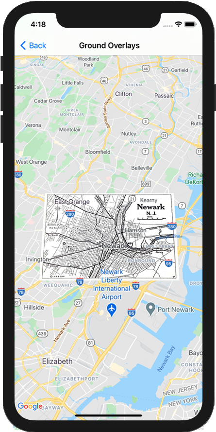
地面叠加层是固定在地图上的图像。与标记不同,地面叠加层朝向地球表面而非屏幕的相反方向,因此旋转、倾斜或缩放地图将会改变图像的朝向。
如需添加地面叠加层,请创建一个同时定义了图标和边界的 GMSGroundOverlay
对象。如果未指定这两个属性中的任何一个,地面叠加层将不会显示在地图上。您还可以选择指定将会影响地图上图像定位的其他设置。定义必要的选项后,请设置此对象的 map
属性以添加叠加层。
添加叠加层
- 实例化一个新的
GMSGroundOverlay
对象。
- 将
icon
属性设置为 UIImage
的实例。
- 将
bounds
属性设置为 GMSCoordinateBounds
的实例。边界表示图像的西南角和东北角。
- 根据需要设置可选属性,例如
bearing
和 zoomLevel
。
- 设置
map
属性 - 图像会显示在地图上。
下例展示了如何将地面叠加层添加到现有的 GMSMapView
对象。
Swift
let southWest = CLLocationCoordinate2D(latitude: 40.712216, longitude: -74.22655)
let northEast = CLLocationCoordinate2D(latitude: 40.773941, longitude: -74.12544)
let overlayBounds = GMSCoordinateBounds(coordinate: southWest, coordinate: northEast)
// Image from http://www.lib.utexas.edu/maps/historical/newark_nj_1922.jpg
let icon = UIImage(named: "newark_nj_1922")
let overlay = GMSGroundOverlay(bounds: overlayBounds, icon: icon)
overlay.bearing = 0
overlay.map = mapView
Objective-C
CLLocationCoordinate2D southWest = CLLocationCoordinate2DMake(40.712216,-74.22655);
CLLocationCoordinate2D northEast = CLLocationCoordinate2DMake(40.773941,-74.12544);
GMSCoordinateBounds *overlayBounds = [[GMSCoordinateBounds alloc] initWithCoordinate:southWest
coordinate:northEast];
// Image from http://www.lib.utexas.edu/maps/historical/newark_nj_1922.jpg
UIImage *icon = [UIImage imageNamed:@"newark_nj_1922"];
GMSGroundOverlay *overlay = [GMSGroundOverlay groundOverlayWithBounds:overlayBounds icon:icon];
overlay.bearing = 0;
overlay.map = mapView;
移除叠加层
您可以通过将 GMSGroundOverlay
的 map
属性设置为 nil
,从地图中移除地面叠加层。或者,您也可以通过调用 GMSMapView
clear
方法来移除所有叠加层(包括当前地图上的地面叠加层)。
Objective-C
[mapView clear];
将地面叠加层添加至地图后,如果您想修改该叠加层,请务必保留 GMSGroundOverlay
对象。稍后您可以通过更改此对象来修改该地面叠加层。
Swift
let overlay = GMSGroundOverlay(bounds: overlayBounds, icon: icon)
overlay.bearing = 0
overlay.map = mapView
// ...
overlay.isTappable = true
Objective-C
GMSGroundOverlay *overlay = [GMSGroundOverlay groundOverlayWithBounds:overlayBounds icon:icon];
overlay.bearing = 0;
overlay.map = mapView;
// ...
overlay.tappable = YES;
事件
您可以监听地图上发生的事件,例如用户点按叠加层时发生的事件。如需监听事件,您必须实现 GMSMapViewDelegate
协议。请参阅有关事件的指南以及 GMSMapViewDelegate
上的方法列表。
如未另行说明,那么本页面中的内容已根据知识共享署名 4.0 许可获得了许可,并且代码示例已根据 Apache 2.0 许可获得了许可。有关详情,请参阅 Google 开发者网站政策。Java 是 Oracle 和/或其关联公司的注册商标。
最后更新时间 (UTC):2025-08-31。
[null,null,["最后更新时间 (UTC):2025-08-31。"],[[["\u003cp\u003eGround overlays are images fixed to a map, oriented to the Earth's surface, and change orientation with map interactions.\u003c/p\u003e\n"],["\u003cp\u003eTo add a ground overlay, create a \u003ccode\u003eGMSGroundOverlay\u003c/code\u003e object, define its icon, bounds, and optional settings, then set its \u003ccode\u003emap\u003c/code\u003e property.\u003c/p\u003e\n"],["\u003cp\u003eGround overlays can be removed by setting the \u003ccode\u003emap\u003c/code\u003e property to \u003ccode\u003enil\u003c/code\u003e or using the \u003ccode\u003eclear\u003c/code\u003e method on the \u003ccode\u003eGMSMapView\u003c/code\u003e.\u003c/p\u003e\n"],["\u003cp\u003eModifications to existing ground overlays can be made by accessing and updating the \u003ccode\u003eGMSGroundOverlay\u003c/code\u003e object directly.\u003c/p\u003e\n"],["\u003cp\u003eImplement the \u003ccode\u003eGMSMapViewDelegate\u003c/code\u003e protocol to listen to events like user taps on the overlay.\u003c/p\u003e\n"]]],["Ground overlays, images fixed to a map using latitude/longitude, are added by creating a `GMSGroundOverlay` object. This requires setting both the `icon` (an image) and `bounds` (southwest/northeast coordinates). Optionally, set properties like `bearing` and `zoomLevel`. To display, assign the object's `map` property. Overlays are removed by setting `map` to `nil` or using the `clear` method. Modifications require retaining the `GMSGroundOverlay` object and to listen for events, you must implement `GMSMapViewDelegate`.\n"],null,["Select platform: [Android](/maps/documentation/android-sdk/groundoverlay \"View this page for the Android platform docs.\") [iOS](/maps/documentation/ios-sdk/overlays \"View this page for the iOS platform docs.\") [JavaScript](/maps/documentation/javascript/groundoverlays \"View this page for the JavaScript platform docs.\")\n\n\u003cbr /\u003e\n\nGround overlays are overlays on the map that are tied to latitude/longitude\ncoordinates, so they move when you drag or zoom the map.\n\nIntroduction\n\nA ground overlay is an image that is fixed to a map. Unlike\n[markers](/maps/documentation/ios-sdk/marker), ground overlays are oriented against the Earth's surface\nrather than the screen, so rotating, tilting or zooming the map will change\nthe orientation of the image.\n\nTo add a ground overlay, create a\n[`GMSGroundOverlay`](/maps/documentation/ios-sdk/reference/objc/Classes/GMSGroundOverlay)\nobject that defines both an icon and a bounds. Failing to specify either will\ncause the ground overlay to not appear on the map. You can optionally specify\nadditional settings that will affect the positioning of the image on the map.\nOnce you've defined the necessary options, set this object's `map` property to\nadd the overlay.\n\nAdding an overlay\n\n1. Instantiate a new `GMSGroundOverlay` object\n2. Set the `icon` property to an instance of `UIImage`.\n3. Set the `bounds` property to an instance of `GMSCoordinateBounds`. The bounds represent the south west, and north east corners of the image.\n4. Set optional properties, such as `bearing` and `zoomLevel`, as desired.\n5. Set the `map` property - the image appears on the map.\n\nThe below example demonstrates how to add a ground overlay to an existing\n`GMSMapView` object.\n\n\nSwift \n\n```swift\nlet southWest = CLLocationCoordinate2D(latitude: 40.712216, longitude: -74.22655)\nlet northEast = CLLocationCoordinate2D(latitude: 40.773941, longitude: -74.12544)\nlet overlayBounds = GMSCoordinateBounds(coordinate: southWest, coordinate: northEast)\n\n// Image from http://www.lib.utexas.edu/maps/historical/newark_nj_1922.jpg\nlet icon = UIImage(named: \"newark_nj_1922\")\n\nlet overlay = GMSGroundOverlay(bounds: overlayBounds, icon: icon)\noverlay.bearing = 0\noverlay.map = mapView\n \n```\n\nObjective-C \n\n```objective-c\nCLLocationCoordinate2D southWest = CLLocationCoordinate2DMake(40.712216,-74.22655);\nCLLocationCoordinate2D northEast = CLLocationCoordinate2DMake(40.773941,-74.12544);\nGMSCoordinateBounds *overlayBounds = [[GMSCoordinateBounds alloc] initWithCoordinate:southWest\n coordinate:northEast];\n\n// Image from http://www.lib.utexas.edu/maps/historical/newark_nj_1922.jpg\nUIImage *icon = [UIImage imageNamed:@\"newark_nj_1922\"];\nGMSGroundOverlay *overlay = [GMSGroundOverlay groundOverlayWithBounds:overlayBounds icon:icon];\noverlay.bearing = 0;\noverlay.map = mapView;\n \n```\n\n\u003cbr /\u003e\n\nRemoving an overlay\n\nYou can remove a ground overlay from the map by setting your\n`GMSGroundOverlay`'s `map` property to `nil`. Alternately, you can remove all\nof the overlays (including ground overlays currently on the map by calling the\n`GMSMapView` `clear` method.\n\n\nSwift \n\n```swift\nmapView.clear()\n \n```\n\nObjective-C \n\n```objective-c\n[mapView clear];\n \n```\n\n\u003cbr /\u003e\n\nIf you wish to make modifications to a ground overlay after you've added it to\nthe map, ensure that you keep hold of the `GMSGroundOverlay` object. You can\nmodify the ground overlay later by making changes to this object.\n\n\nSwift \n\n```swift\nlet overlay = GMSGroundOverlay(bounds: overlayBounds, icon: icon)\noverlay.bearing = 0\noverlay.map = mapView\n\n// ...\n\noverlay.isTappable = true\n \n```\n\nObjective-C \n\n```objective-c\nGMSGroundOverlay *overlay = [GMSGroundOverlay groundOverlayWithBounds:overlayBounds icon:icon];\noverlay.bearing = 0;\noverlay.map = mapView;\n\n// ...\noverlay.tappable = YES;\n \n```\n\n\u003cbr /\u003e\n\nEvents\n\nYou can listen to events that occur on the map, such as when a user taps an\noverlay. To listen to events, you must implement the\n[`GMSMapViewDelegate`](/maps/documentation/ios-sdk/reference/objc/Protocols/GMSMapViewDelegate) protocol. See the\n[guide to events](/maps/documentation/ios-sdk/events) and the list of methods on the\n[`GMSMapViewDelegate`](/maps/documentation/ios-sdk/reference/objc/Protocols/GMSMapViewDelegate)."]]