
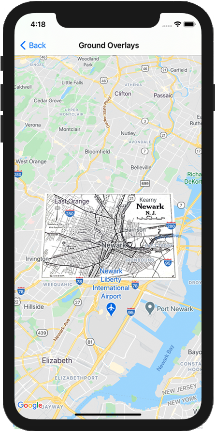
همپوشانیهای زمینی، پوششهایی روی نقشه هستند که به مختصات طول و عرض جغرافیایی گره خوردهاند، بنابراین وقتی نقشه را میکشید یا بزرگنمایی میکنید، حرکت میکنند.
مقدمه
پوشش زمین تصویری است که روی نقشه ثابت می شود. بر خلاف نشانگرها ، روکشهای زمین به جای صفحه نمایش، روی سطح زمین قرار دارند، بنابراین چرخش، کج کردن یا بزرگنمایی نقشه، جهت تصویر را تغییر میدهد.
برای افزودن همپوشانی زمین، یک شی GMSGroundOverlay ایجاد کنید که هم نماد و هم مرز را تعریف می کند. عدم تعیین هر کدام باعث می شود که پوشش زمین روی نقشه ظاهر نشود. شما می توانید به صورت اختیاری تنظیمات اضافی را تعیین کنید که بر موقعیت تصویر روی نقشه تأثیر می گذارد. هنگامی که گزینه های لازم را تعریف کردید، ویژگی map این شی را برای اضافه کردن همپوشانی تنظیم کنید.
اضافه کردن یک پوشش
- یک شی جدید
GMSGroundOverlayرا نمونه سازی کنید - ویژگی
iconرا روی یک نمونه ازUIImageتنظیم کنید. - ویژگی
boundsرا روی یک نمونه ازGMSCoordinateBoundsتنظیم کنید. حاشیه ها نمایانگر گوشه های جنوب غربی و شمال شرقی تصویر هستند. - ویژگی های اختیاری، مانند
bearingوzoomLevelبه صورت دلخواه تنظیم کنید. - ویژگی
mapرا تنظیم کنید - تصویر روی نقشه ظاهر می شود.
مثال زیر نحوه اضافه کردن یک همپوشانی زمین به یک شی GMSMapView موجود را نشان می دهد.
سویفت
let southWest = CLLocationCoordinate2D(latitude: 40.712216, longitude: -74.22655)
let northEast = CLLocationCoordinate2D(latitude: 40.773941, longitude: -74.12544)
let overlayBounds = GMSCoordinateBounds(coordinate: southWest, coordinate: northEast)

// Image from http://www.lib.utexas.edu/maps/historical/newark_nj_1922.jpg
let icon = UIImage(named: "newark_nj_1922")

let overlay = GMSGroundOverlay(bounds: overlayBounds, icon: icon)
overlay.bearing = 0
overlay.map = mapView
هدف-C
CLLocationCoordinate2D southWest = CLLocationCoordinate2DMake(40.712216,-74.22655);
CLLocationCoordinate2D northEast = CLLocationCoordinate2DMake(40.773941,-74.12544);
GMSCoordinateBounds *overlayBounds = [[GMSCoordinateBounds alloc] initWithCoordinate:southWest
                                                                        coordinate:northEast];

// Image from http://www.lib.utexas.edu/maps/historical/newark_nj_1922.jpg
UIImage *icon = [UIImage imageNamed:@"newark_nj_1922"];
GMSGroundOverlay *overlay = [GMSGroundOverlay groundOverlayWithBounds:overlayBounds icon:icon];
overlay.bearing = 0;
overlay.map = mapView;
حذف یک پوشش
می توانید با تنظیم ویژگی map GMSGroundOverlay خود بر روی nil یک پوشش زمین را از نقشه حذف کنید. متناوباً، میتوانید با فراخوانی روش clear GMSMapView همه پوششها (از جمله پوششهای زمینی که در حال حاضر روی نقشه وجود دارد) را حذف کنید.
سویفت
mapView.clear()
هدف-C
[mapView clear];
اگر میخواهید پس از افزودن آن به نقشه، روی همپوشانی زمین تغییراتی ایجاد کنید، مطمئن شوید که شی GMSGroundOverlay را نگه دارید. بعداً میتوانید با ایجاد تغییرات در این شی، پوشش زمین را تغییر دهید.
سویفت
let overlay = GMSGroundOverlay(bounds: overlayBounds, icon: icon)
overlay.bearing = 0
overlay.map = mapView

// ...

overlay.isTappable = true
هدف-C
GMSGroundOverlay *overlay = [GMSGroundOverlay groundOverlayWithBounds:overlayBounds icon:icon];
overlay.bearing = 0;
overlay.map = mapView;

// ...
overlay.tappable = YES;
رویدادها
میتوانید به رویدادهایی که روی نقشه رخ میدهند گوش دهید، مانند زمانی که کاربر روی یک پوشش ضربه میزند. برای گوش دادن به رویدادها، باید پروتکل GMSMapViewDelegate پیاده سازی کنید. راهنمای رویدادها و فهرست روشها را در GMSMapViewDelegate ببینید.