區域疊加層
透過集合功能整理內容
你可以依據偏好儲存及分類內容。
區域疊加層是指地圖上與經緯度座標連動的疊加層,因此會隨著您拖曳或縮放地圖而移動。

簡介
區域疊加層是指固定於地圖上的圖片。不同於標記,區域疊加層顯示方向的依據是實際地表而非裝置螢幕,因此旋轉、傾斜或縮放地圖時,圖片的方向也會隨之改變。
如要新增地面疊加層,請建立用於定義圖示和邊界的 GMSGroundOverlay
物件。如果未指定其中一項,地圖上就不會顯示區域疊加層。您可以視需要指定額外設定,影響地圖上圖片的位置。定義必要的選項後,請設定這個物件的 map
屬性,即可新增疊加層。
新增疊加層
- 將新的
GMSGroundOverlay
物件執行個體化
- 將
icon
屬性設為 UIImage
的例項。
- 將
bounds
屬性設為 GMSCoordinateBounds
的例項。bounds 代表圖片的西南角和東北角。
- 視需要設定選用屬性,例如
bearing
和 zoomLevel
。
- 設定
map
屬性,地圖上就會顯示圖片。
以下範例說明如何將區域疊加層加到現有的 GMSMapView
物件。
Swift
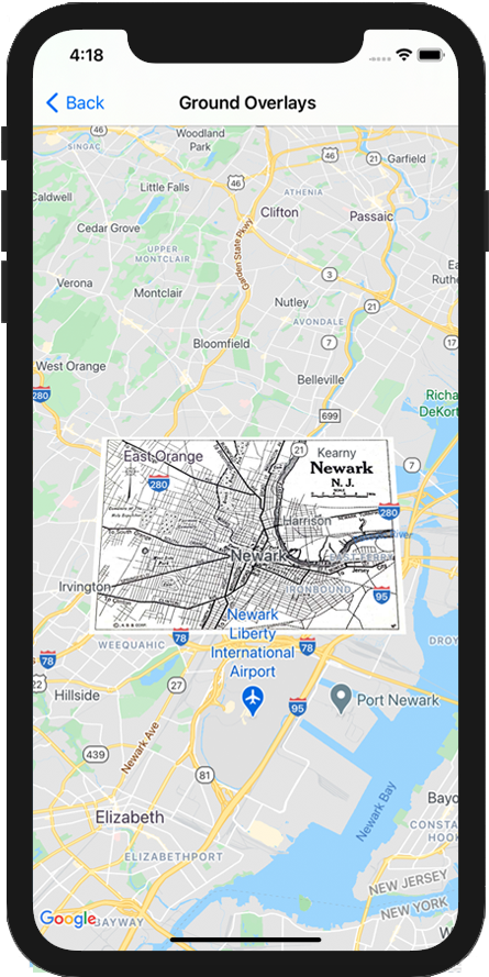
let southWest = CLLocationCoordinate2D(latitude: 40.712216, longitude: -74.22655)
let northEast = CLLocationCoordinate2D(latitude: 40.773941, longitude: -74.12544)
let overlayBounds = GMSCoordinateBounds(coordinate: southWest, coordinate: northEast)
// Image from http://www.lib.utexas.edu/maps/historical/newark_nj_1922.jpg
let icon = UIImage(named: "newark_nj_1922")
let overlay = GMSGroundOverlay(bounds: overlayBounds, icon: icon)
overlay.bearing = 0
overlay.map = mapView
Objective-C
CLLocationCoordinate2D southWest = CLLocationCoordinate2DMake(40.712216,-74.22655);
CLLocationCoordinate2D northEast = CLLocationCoordinate2DMake(40.773941,-74.12544);
GMSCoordinateBounds *overlayBounds = [[GMSCoordinateBounds alloc] initWithCoordinate:southWest
coordinate:northEast];
// Image from http://www.lib.utexas.edu/maps/historical/newark_nj_1922.jpg
UIImage *icon = [UIImage imageNamed:@"newark_nj_1922"];
GMSGroundOverlay *overlay = [GMSGroundOverlay groundOverlayWithBounds:overlayBounds icon:icon];
overlay.bearing = 0;
overlay.map = mapView;
移除疊加層
如要從地圖中移除區域疊加層,請將 GMSGroundOverlay
的 map
屬性設為 nil
。或者,您也可以呼叫 GMSMapView
clear
方法,移除所有疊加層 (包括目前地圖上的區域疊加層)。
Objective-C
[mapView clear];
如果您在區域疊加層加到地圖中之後,想要予以修改,請務必保留 GMSGroundOverlay
物件,這樣稍後您只要變更這個物件,就可以修改地面疊加層。
Swift
let overlay = GMSGroundOverlay(bounds: overlayBounds, icon: icon)
overlay.bearing = 0
overlay.map = mapView
// ...
overlay.isTappable = true
Objective-C
GMSGroundOverlay *overlay = [GMSGroundOverlay groundOverlayWithBounds:overlayBounds icon:icon];
overlay.bearing = 0;
overlay.map = mapView;
// ...
overlay.tappable = YES;
事件
您可以監聽地圖上發生的事件,例如使用者輕觸疊加層。如要監聽事件,請導入 GMSMapViewDelegate
通訊協定。請參閱事件指南和 GMSMapViewDelegate
中的方法清單。
除非另有註明,否則本頁面中的內容是採用創用 CC 姓名標示 4.0 授權,程式碼範例則為阿帕契 2.0 授權。詳情請參閱《Google Developers 網站政策》。Java 是 Oracle 和/或其關聯企業的註冊商標。
上次更新時間:2025-08-31 (世界標準時間)。
[null,null,["上次更新時間:2025-08-31 (世界標準時間)。"],[[["\u003cp\u003eGround overlays are images fixed to a map, oriented to the Earth's surface, and change orientation with map interactions.\u003c/p\u003e\n"],["\u003cp\u003eTo add a ground overlay, create a \u003ccode\u003eGMSGroundOverlay\u003c/code\u003e object, define its icon, bounds, and optional settings, then set its \u003ccode\u003emap\u003c/code\u003e property.\u003c/p\u003e\n"],["\u003cp\u003eGround overlays can be removed by setting the \u003ccode\u003emap\u003c/code\u003e property to \u003ccode\u003enil\u003c/code\u003e or using the \u003ccode\u003eclear\u003c/code\u003e method on the \u003ccode\u003eGMSMapView\u003c/code\u003e.\u003c/p\u003e\n"],["\u003cp\u003eModifications to existing ground overlays can be made by accessing and updating the \u003ccode\u003eGMSGroundOverlay\u003c/code\u003e object directly.\u003c/p\u003e\n"],["\u003cp\u003eImplement the \u003ccode\u003eGMSMapViewDelegate\u003c/code\u003e protocol to listen to events like user taps on the overlay.\u003c/p\u003e\n"]]],["Ground overlays, images fixed to a map using latitude/longitude, are added by creating a `GMSGroundOverlay` object. This requires setting both the `icon` (an image) and `bounds` (southwest/northeast coordinates). Optionally, set properties like `bearing` and `zoomLevel`. To display, assign the object's `map` property. Overlays are removed by setting `map` to `nil` or using the `clear` method. Modifications require retaining the `GMSGroundOverlay` object and to listen for events, you must implement `GMSMapViewDelegate`.\n"],null,["Select platform: [Android](/maps/documentation/android-sdk/groundoverlay \"View this page for the Android platform docs.\") [iOS](/maps/documentation/ios-sdk/overlays \"View this page for the iOS platform docs.\") [JavaScript](/maps/documentation/javascript/groundoverlays \"View this page for the JavaScript platform docs.\")\n\n\u003cbr /\u003e\n\nGround overlays are overlays on the map that are tied to latitude/longitude\ncoordinates, so they move when you drag or zoom the map.\n\nIntroduction\n\nA ground overlay is an image that is fixed to a map. Unlike\n[markers](/maps/documentation/ios-sdk/marker), ground overlays are oriented against the Earth's surface\nrather than the screen, so rotating, tilting or zooming the map will change\nthe orientation of the image.\n\nTo add a ground overlay, create a\n[`GMSGroundOverlay`](/maps/documentation/ios-sdk/reference/objc/Classes/GMSGroundOverlay)\nobject that defines both an icon and a bounds. Failing to specify either will\ncause the ground overlay to not appear on the map. You can optionally specify\nadditional settings that will affect the positioning of the image on the map.\nOnce you've defined the necessary options, set this object's `map` property to\nadd the overlay.\n\nAdding an overlay\n\n1. Instantiate a new `GMSGroundOverlay` object\n2. Set the `icon` property to an instance of `UIImage`.\n3. Set the `bounds` property to an instance of `GMSCoordinateBounds`. The bounds represent the south west, and north east corners of the image.\n4. Set optional properties, such as `bearing` and `zoomLevel`, as desired.\n5. Set the `map` property - the image appears on the map.\n\nThe below example demonstrates how to add a ground overlay to an existing\n`GMSMapView` object.\n\n\nSwift \n\n```swift\nlet southWest = CLLocationCoordinate2D(latitude: 40.712216, longitude: -74.22655)\nlet northEast = CLLocationCoordinate2D(latitude: 40.773941, longitude: -74.12544)\nlet overlayBounds = GMSCoordinateBounds(coordinate: southWest, coordinate: northEast)\n\n// Image from http://www.lib.utexas.edu/maps/historical/newark_nj_1922.jpg\nlet icon = UIImage(named: \"newark_nj_1922\")\n\nlet overlay = GMSGroundOverlay(bounds: overlayBounds, icon: icon)\noverlay.bearing = 0\noverlay.map = mapView\n \n```\n\nObjective-C \n\n```objective-c\nCLLocationCoordinate2D southWest = CLLocationCoordinate2DMake(40.712216,-74.22655);\nCLLocationCoordinate2D northEast = CLLocationCoordinate2DMake(40.773941,-74.12544);\nGMSCoordinateBounds *overlayBounds = [[GMSCoordinateBounds alloc] initWithCoordinate:southWest\n coordinate:northEast];\n\n// Image from http://www.lib.utexas.edu/maps/historical/newark_nj_1922.jpg\nUIImage *icon = [UIImage imageNamed:@\"newark_nj_1922\"];\nGMSGroundOverlay *overlay = [GMSGroundOverlay groundOverlayWithBounds:overlayBounds icon:icon];\noverlay.bearing = 0;\noverlay.map = mapView;\n \n```\n\n\u003cbr /\u003e\n\nRemoving an overlay\n\nYou can remove a ground overlay from the map by setting your\n`GMSGroundOverlay`'s `map` property to `nil`. Alternately, you can remove all\nof the overlays (including ground overlays currently on the map by calling the\n`GMSMapView` `clear` method.\n\n\nSwift \n\n```swift\nmapView.clear()\n \n```\n\nObjective-C \n\n```objective-c\n[mapView clear];\n \n```\n\n\u003cbr /\u003e\n\nIf you wish to make modifications to a ground overlay after you've added it to\nthe map, ensure that you keep hold of the `GMSGroundOverlay` object. You can\nmodify the ground overlay later by making changes to this object.\n\n\nSwift \n\n```swift\nlet overlay = GMSGroundOverlay(bounds: overlayBounds, icon: icon)\noverlay.bearing = 0\noverlay.map = mapView\n\n// ...\n\noverlay.isTappable = true\n \n```\n\nObjective-C \n\n```objective-c\nGMSGroundOverlay *overlay = [GMSGroundOverlay groundOverlayWithBounds:overlayBounds icon:icon];\noverlay.bearing = 0;\noverlay.map = mapView;\n\n// ...\noverlay.tappable = YES;\n \n```\n\n\u003cbr /\u003e\n\nEvents\n\nYou can listen to events that occur on the map, such as when a user taps an\noverlay. To listen to events, you must implement the\n[`GMSMapViewDelegate`](/maps/documentation/ios-sdk/reference/objc/Protocols/GMSMapViewDelegate) protocol. See the\n[guide to events](/maps/documentation/ios-sdk/events) and the list of methods on the\n[`GMSMapViewDelegate`](/maps/documentation/ios-sdk/reference/objc/Protocols/GMSMapViewDelegate)."]]