רוצה להוסיף תכונות מתקדמות למפות? מפות ה-SDK של מפות Google ל-iOS
Library ב-GitHub היא ספרייה בקוד פתוח של מחלקות שמתאימות למגוון אפליקציות. במאגר של GitHub יש את המחלקות של כלי השירות ואפליקציית הדגמה (דמו) שממחישה את השימוש בכל מחלקה.
התשתיות
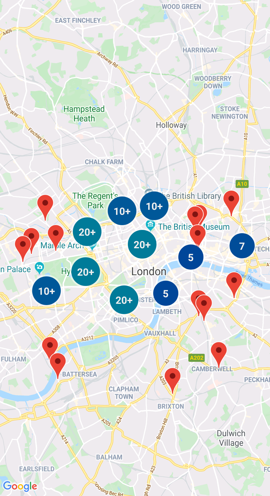
יצירת אשכולות של סמנים
GMUClusterManager עוזר לך לנהל מספר סמנים
ברמות זום שונות. המשמעות היא שאפשר להוסיף הרבה סמנים
למפה בלי להקשות על הקריאה. כשמשתמש מציג את המפה
ברמת זום גבוהה, הסמנים השונים מופיעים במפה. אם המשתמש מקטין את התצוגה לרמה נמוכה יותר של זום, הסמנים מקובצים יחד לאשכולות, כדי להקל על הצפייה במפה.
למידע נוסף, עיינו במסמכי התיעוד בנושא
אשכול הסמנים.
אין תמונה עבור כלי עזר זה.
מרובע
מרובע הוא מבנה נתונים שעוזר למצוא נקודות ליד נקודה אחת, על ידי חיפוש בתוך אזור שמקיף את נקודת העניין.
במסמכי העזרה של Quadtree תוכלו לקרוא פרטים נוספים.
KML
KML הוא פורמט פופולרי לעיבוד נתונים גיאוגרפיים כמו
נקודות, קווים ופוליגונים. GMUKMLParser
מאפשר לנתח ולעבד נתונים גיאוגרפיים בפורמט KML.
אפשר לאחסן תכונות בפורמט GeoJSON ולהשתמש בכלי השירות הזה כדי להציג אותן כשכבה על גבי מפה.
עבד נתונים גיאוגרפיים בפורמט GeoJSON באמצעות GMUGeoJSONParser
בשילוב עם GMUGeometryRenderer.
לפרטים נוספים אפשר לעיין במסמכי התיעוד של GeoJSON.
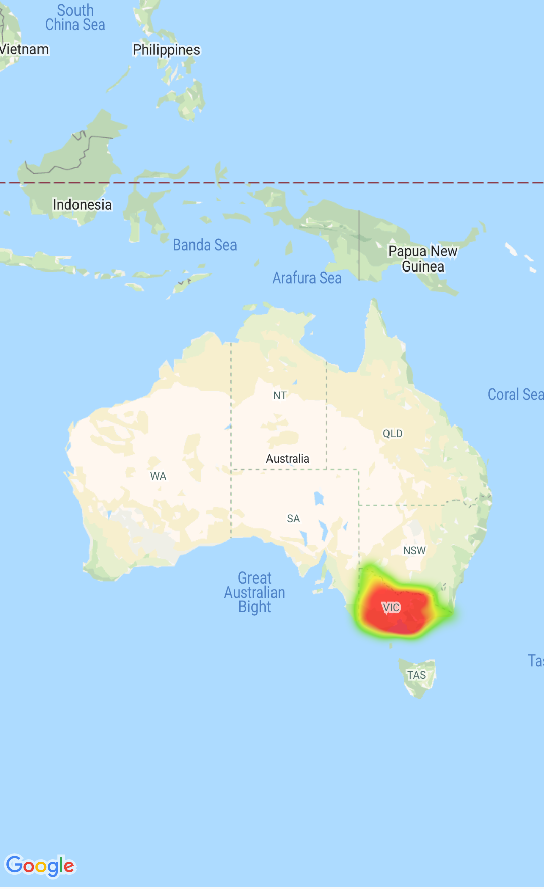
מפות חום
מפות חום מאפשרות לצופים להבין בקלות את ההתפלגות ואת
העוצמה היחסית של נקודות נתונים במפה. במקום להציב סמן בכל
מיקום, במפות חום נעשה שימוש בצבע ובצורה כדי לייצג את התפלגות הנתונים.
אפשר להשתמש בהקצאה GMUClusterRendererDelegate
ב-GMUDefaultClusterRenderer כדי להתאים אישית את המאפיינים של סמן לפני ואחרי הוספתו למפה.
תוכניות שירות גיאומטריות
קבוצת פונקציות שירות של גיאומטריה כדורית של Swift של המודול GMSGeometryUtils של ה-SDK של מפות Google ל-iOS. אפשר להשתמש בתוספים האלה כדי לבצע סוגים רבים של פעולות גיאומטריות, כולל:
מצאו את מרחק העיגול הגדול בין קואורדינטות
החליטו אם קואורדינטה נמצאת בתוך מצולע
החליטו אם קואורדינטה נמצאת על נתיב או קרוב אליו בטווח רגישות שצוינה
[null,null,["עדכון אחרון: 2025-07-26 (שעון UTC)."],[[["\u003cp\u003eThe Maps SDK for iOS Utility Library is an open-source library providing advanced features for your maps.\u003c/p\u003e\n"],["\u003cp\u003eThis library offers utilities for marker clustering, quadtrees, KML parsing, GeoJSON rendering, heatmaps, custom markers, and geometry operations.\u003c/p\u003e\n"],["\u003cp\u003eThe library includes a demo app demonstrating the use of each class.\u003c/p\u003e\n"],["\u003cp\u003eAccess the Maps SDK for iOS Utility Library and its documentation on GitHub.\u003c/p\u003e\n"]]],["The Maps SDK for iOS Utility Library offers tools for enhancing maps, including marker clustering via `GMUClusterManager` for managing numerous markers at different zoom levels. It also supports quadtrees for proximity searches, KML and GeoJSON format parsing for rendering geographic data, and heatmaps for visualizing data density. The library allows custom marker properties through `GMUClusterRendererDelegate` and provides geometry utilities (`GMSGeometryUtils`) for tasks like distance calculation and polygon analysis.\n"],null,["Select platform: [Android](/maps/documentation/android-sdk/utility \"View this page for the Android platform docs.\") [iOS](/maps/documentation/ios-sdk/utility \"View this page for the iOS platform docs.\")\n\nLooking for advanced features to add to your maps? The\n[Maps SDK for iOS\nUtility Library](https://github.com/googlemaps/google-maps-ios-utils) on GitHub is an open-source library of classes that are\nuseful for a range of applications. The GitHub repository includes the utility\nclasses and a demo app that illustrates the use of each class.\n\nThe utilities\n\n|----------------------------|----------------------------------------------------------------------------------------------------------------------------------------------------------------------------------------------------------------------------------------------------------------------------------------------------------------------------------------------------------------------------------------------------------------------------------------------------------------------------------------------------------------------------------------------|\n| | Marker Clustering The `GMUClusterManager` helps you manage multiple markers at different zoom levels. This means you can put a large number of markers on a map without making the map hard to read. When a user views the map at a high zoom level, the individual markers show on the map. When the user zooms out to a lower zoom level, the markers gather together into clusters, to make viewing the map easier. For details, see the documentation on the [Marker Clustering](/maps/documentation/ios-sdk/utility/marker-clustering). |\n| No image for this utility. | Quadtree A quadtree is a data structure that's useful for finding points near a single point, by searching inside an area surrounding the point of interest. For details, see the documentation on the [Quadtree](/maps/documentation/ios-sdk/utility/quadtree). |\n| | KML KML is a popular format for rendering geographic data such as points, lines, and polygons. The `GMUKMLParser` lets you parse and render geographic data in the KML format. For details, see the documentation on the [KML](/maps/documentation/ios-sdk/utility/kml). |\n| | Import GeoJSON onto your map You can store features in [GeoJSON](http://geojson.org/) format and use this utility to render them as a layer on top of a map. Render geographic data in the GeoJSON format using `GMUGeoJSONParser` in conjunction with `GMUGeometryRenderer`. For details, see the documentation on the [GeoJSON](/maps/documentation/ios-sdk/utility/geojson). |\n| | Heatmaps Heatmaps make it easy for viewers to understand the distribution and relative intensity of data points on a map. Rather than placing a marker at each location, heatmaps use color and shape to represent the distribution of data. For details, see the documentation on the [Heatmaps](/maps/documentation/ios-sdk/utility/heatmap). |\n| | Custom markers Use the delegate [`GMUClusterRendererDelegate`](https://github.com/googlemaps/google-maps-ios-utils/blob/master/src/Clustering/View/GMUDefaultClusterRenderer.h) on `GMUDefaultClusterRenderer` to customize the properties of a marker before and after it is added to the map. |\n| | Geometry utilities A set of Swift spherical geometry utility functions of the [`GMSGeometryUtils`](/maps/documentation/ios-sdk/reference/objc/Functions) module of the Maps SDK for iOS. Use these extensions to perform many types of geometric operations, including: - Determine the great circle distance between coordinates - Determine if a coordinate is inside a polygon - Determine if a coordinate lies on or near a path within a specified tolerance - Determine the area of this polygon - many others |"]]