Global Land Ice Measurements from Space (GLIMS) is
an international initiative with the goal of repeatedly surveying
the world's estimated 200,000 glaciers.
The project seeks
to create a globally comprehensive inventory of land ice, including
measurements of glacier area, geometry, surface velocity, and
snow line elevation. To perform these analyses, the GLIMS project
uses satellite data, primarily from the Advanced Spaceborne Thermal
Emission and Reflection Radiometer (ASTER) and the Landsat Enhanced
Thematic Mapper Plus (ETM+), as well as historical information
derived from maps and aerial photographs.
Each feature in this dataset is a polygonal boundary of a glacier at the
time of analysis. A few glacier IDs have hundreds of distinct rows over
time.
This dataset is a snapshot of the inventory of glacier boundaries as of
June 7, 2023, providing over 1,100,000 rows.
Table Schema
Table Schema
Name
Type
Description
analysts
STRING
Name(s) of data contributor(s)
anlys_id
DOUBLE
ID of a glacier at a particular time
anlys_time
STRING
When the analysis was done
area
DOUBLE
Area of the glacier in the plane of the map
projection in square kilometers
chief_affl
STRING
Affiliation of the chief of the regional center
db_area
DOUBLE
Same as 'area', but recomputed by the GLIMS project
geog_area
STRING
Name of geographic region covered by the regional center
glac_id
STRING
The GLIMS glacier ID
glac_name
STRING
The glacier name. ~80% of the rows equal 'None'
glac_stat
STRING
Glacier status, either 'exists' or 'None'
length
DOUBLE
Length of the glacier perimeter in meters
line_type
STRING
Glacier record type, e.g. 'glac_bound' for glaciers,
or other values for internal rocks, snowlines, water features,
etc.
local_id
STRING
ID assigned by the contributing institution or regional center
max_elev
DOUBLE
Highest part of the glacier, in meters above sea level
mean_elev
DOUBLE
Mean elevation of the glacier, in meters above sea level
min_elev
DOUBLE
Lowest part of the glacier, in meters above sea level
parent_id
STRING
ID of the glacier that is the parent of this glacier
primeclass
DOUBLE
WGMS glacier classification number
proc_desc
STRING
Description of processing done on this record
rc_id
DOUBLE
ID used by the regional center
rec_status
STRING
Record status
release_dt
STRING
Date data was released, in YYYY-MM-ddTHH:mm:ss format
src_date
STRING
Date of source imagery used to create the outline
subm_id
DOUBLE
The submission ID assigned by GLIMS
submitters
STRING
Name(s) of data submitter(s)
wgms_id
STRING
World Glacier Monitoring Service ID
width
DOUBLE
Width of the glacier in meters
Terms of Use
Terms of Use
For the creation of any reports, publications, new
data sets, derived products, or services resulting from the data
set, users should cite: GLIMS and NSIDC (2005, updated 2013): Global
Land Ice Measurements from Space glacier database. Compiled and
made available by the international GLIMS community and the National
Snow and Ice Data Center, Boulder CO, U.S.A.,
doi:10.7265/N5V98602
Global Land Ice Measurements from Space (GLIMS) is an international initiative with the goal of repeatedly surveying the world's estimated 200,000 glaciers. The project seeks to create a globally comprehensive inventory of land ice, including measurements of glacier area, geometry, surface velocity, and snow line elevation. To perform these analyses, …
[null,null,[],[[["\u003cp\u003e\u003cstrong\u003eCaution:\u003c/strong\u003e This dataset has been replaced by a newer version, GLIMS/20230607.\u003c/p\u003e\n"],["\u003cp\u003eGLIMS is an international project creating a global inventory of glacier boundaries, including measurements of glacier area, geometry, velocity, and snow line elevation.\u003c/p\u003e\n"],["\u003cp\u003eThe dataset comprises over 1,100,000 rows, representing glacier boundaries primarily derived from ASTER and Landsat satellite data.\u003c/p\u003e\n"],["\u003cp\u003eEach feature in the dataset represents a glacier's polygonal boundary at the time of analysis, with attributes like area, elevation, and source imagery date.\u003c/p\u003e\n"],["\u003cp\u003eUsers of this dataset for publications or derived products should cite GLIMS and NSIDC, providing the associated DOI.\u003c/p\u003e\n"]]],[],null,["# GLIMS Current: Global Land Ice Measurements From Space\n\nDataset Availability\n: 1750-01-01T00:00:00Z--2023-06-07T00:00:00Z\n\nDataset Provider\n:\n\n\n [National Snow and Ice Data Center (NSDIC)](https://www.glims.org)\n\nTags\n:\n[cryosphere](/earth-engine/datasets/tags/cryosphere) [glacier](/earth-engine/datasets/tags/glacier) [glims](/earth-engine/datasets/tags/glims) [ice](/earth-engine/datasets/tags/ice) [landcover](/earth-engine/datasets/tags/landcover) [nasa](/earth-engine/datasets/tags/nasa) [nsidc](/earth-engine/datasets/tags/nsidc) [snow](/earth-engine/datasets/tags/snow) [table](/earth-engine/datasets/tags/table) \n\n#### Description\n\nGlobal Land Ice Measurements from Space (GLIMS) is\nan international initiative with the goal of repeatedly surveying\nthe world's estimated 200,000 glaciers.\n\nThe project seeks\nto create a globally comprehensive inventory of land ice, including\nmeasurements of glacier area, geometry, surface velocity, and\nsnow line elevation. To perform these analyses, the GLIMS project\nuses satellite data, primarily from the Advanced Spaceborne Thermal\nEmission and Reflection Radiometer (ASTER) and the Landsat Enhanced\nThematic Mapper Plus (ETM+), as well as historical information\nderived from maps and aerial photographs.\n\nEach feature in this dataset is a polygonal boundary of a glacier at the\ntime of analysis. A few glacier IDs have hundreds of distinct rows over\ntime.\n\nThis dataset is a snapshot of the inventory of glacier boundaries as of\nJune 7, 2023, providing over 1,100,000 rows.\n\n### Table Schema\n\n**Table Schema**\n\n| Name | Type | Description |\n|------------|--------|--------------------------------------------------------------------------------------------------------------------------|\n| analysts | STRING | Name(s) of data contributor(s) |\n| anlys_id | DOUBLE | ID of a glacier at a particular time |\n| anlys_time | STRING | When the analysis was done |\n| area | DOUBLE | Area of the glacier in the plane of the map projection in square kilometers |\n| chief_affl | STRING | Affiliation of the chief of the regional center |\n| db_area | DOUBLE | Same as 'area', but recomputed by the GLIMS project |\n| geog_area | STRING | Name of geographic region covered by the regional center |\n| glac_id | STRING | The GLIMS glacier ID |\n| glac_name | STRING | The glacier name. \\~80% of the rows equal 'None' |\n| glac_stat | STRING | Glacier status, either 'exists' or 'None' |\n| length | DOUBLE | Length of the glacier perimeter in meters |\n| line_type | STRING | Glacier record type, e.g. 'glac_bound' for glaciers, or other values for internal rocks, snowlines, water features, etc. |\n| local_id | STRING | ID assigned by the contributing institution or regional center |\n| max_elev | DOUBLE | Highest part of the glacier, in meters above sea level |\n| mean_elev | DOUBLE | Mean elevation of the glacier, in meters above sea level |\n| min_elev | DOUBLE | Lowest part of the glacier, in meters above sea level |\n| parent_id | STRING | ID of the glacier that is the parent of this glacier |\n| primeclass | DOUBLE | WGMS glacier classification number |\n| proc_desc | STRING | Description of processing done on this record |\n| rc_id | DOUBLE | ID used by the regional center |\n| rec_status | STRING | Record status |\n| release_dt | STRING | Date data was released, in YYYY-MM-ddTHH:mm:ss format |\n| src_date | STRING | Date of source imagery used to create the outline |\n| subm_id | DOUBLE | The submission ID assigned by GLIMS |\n| submitters | STRING | Name(s) of data submitter(s) |\n| wgms_id | STRING | World Glacier Monitoring Service ID |\n| width | DOUBLE | Width of the glacier in meters |\n\n### Terms of Use\n\n**Terms of Use**\n\nFor the creation of any reports, publications, new\ndata sets, derived products, or services resulting from the data\nset, users should cite: GLIMS and NSIDC (2005, updated 2013): Global\nLand Ice Measurements from Space glacier database. Compiled and\nmade available by the international GLIMS community and the National\nSnow and Ice Data Center, Boulder CO, U.S.A.,\n[doi:10.7265/N5V98602](https://doi.org/10.7265/N5V98602)\n\n### DOIs\n\n- \u003chttps://doi.org/10.7265/N5V98602\u003e\n\n### Explore with Earth Engine\n\n| **Important:** Earth Engine is a platform for petabyte-scale scientific analysis and visualization of geospatial datasets, both for public benefit and for business and government users. Earth Engine is free to use for research, education, and nonprofit use. To get started, please [register for Earth Engine access.](https://console.cloud.google.com/earth-engine)\n\n### Code Editor (JavaScript)\n\n```javascript\n
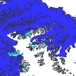
var dataset = ee.FeatureCollection('GLIMS/current');\nvar visParams = {\n palette: ['gray', 'cyan', 'blue'],\n min: 0.0,\n max: 10.0,\n opacity: 0.8,\n};\nvar image = ee.Image().float().paint(dataset, 'area');\nMap.setCenter(-35.618, 66.743, 7);\nMap.addLayer(image, visParams, 'GLIMS/current');\nMap.addLayer(dataset, null, 'for Inspector', false);\n```\n[Open in Code Editor](https://code.earthengine.google.com/?scriptPath=Examples:Datasets/GLIMS/GLIMS_current)\n\n### Visualize as a FeatureView\n\n\nA `FeatureView` is a view-only, accelerated representation of a\n`FeatureCollection`. For more details, visit the\n[`FeatureView` documentation.](/earth-engine/guides/featureview_overview)\n| **Important:** Earth Engine is a platform for petabyte-scale scientific analysis and visualization of geospatial datasets, both for public benefit and for business and government users. Earth Engine is free to use for research, education, and nonprofit use. To get started, please [register for Earth Engine access.](https://console.cloud.google.com/earth-engine)\n\n### Code Editor (JavaScript)\n\n```javascript\nvar fvLayer = ui.Map.FeatureViewLayer('GLIMS/current_FeatureView');\n\nvar visParams = {\n color: {\n property: 'area',\n mode: 'linear',\n palette: ['gray', 'cyan', 'blue'],\n min: 0.0,\n max: 10.0\n },\n opacity: 0.8,\n polygonStrokeOpacity: 0\n};\n\nfvLayer.setVisParams(visParams);\nfvLayer.setName('GLIMS/current');\n\nMap.setCenter(-35.618, 66.743, 7);\nMap.add(fvLayer);\n```\n[Open in Code Editor](https://code.earthengine.google.com/?scriptPath=Examples:Datasets/GLIMS/GLIMS_current_FeatureView) \n[GLIMS Current: Global Land Ice Measurements From Space](/earth-engine/datasets/catalog/GLIMS_current) \nGlobal Land Ice Measurements from Space (GLIMS) is an international initiative with the goal of repeatedly surveying the world's estimated 200,000 glaciers. The project seeks to create a globally comprehensive inventory of land ice, including measurements of glacier area, geometry, surface velocity, and snow line elevation. To perform these analyses, ... \nGLIMS/current, cryosphere,glacier,glims,ice,landcover,nasa,nsidc,snow,table \n1750-01-01T00:00:00Z/2023-06-07T00:00:00Z \n-90 -180 90 180 \nGoogle Earth Engine \nhttps://developers.google.com/earth-engine/datasets\n\n- [https://doi.org/10.7265/N5V98602](https://doi.org/https://www.glims.org)\n- [https://doi.org/10.7265/N5V98602](https://doi.org/https://developers.google.com/earth-engine/datasets/catalog/GLIMS_current)"]]