The NOAA Climate Data Record (CDR) of AVHRR Surface Reflectance contains
gridded daily surface reflectance and brightness temperatures derived from
the Advanced Very High Resolution Radiometer (AVHRR) sensors onboard seven
NOAA polar orbiting satellites. The data are gridded at a
resolution of 0.05° and computed globally over land surfaces.
Known issues with this dataset include:
TIMEOFDAY variable contains values that are too large by 1 day
Latitude values are not correctly associated with the center of
the grid cell, error is < 0.002 degrees
Longitude values are not correctly associated with the center of
the grid cell, error is < 0.02 degrees
Provider's note: the orbital drift of N-19 (the last NOAA satellite
carrying the AVHRR sensor) began to severely degrade the retrieved
product quality. Therefore, VIIRS is now the primary sensor being used for
these products from 2014-present.
Bands
Pixel Size 5566 meters
Bands
Name
Units
Min
Max
Scale
Pixel Size
Wavelength
Description
SREFL_CH1
1*
10000*
0.0001
meters
640nm
Bidirectional surface reflectance
SREFL_CH2
1*
10000*
0.0001
meters
860nm
Bidirectional surface reflectance
SREFL_CH3
-32768*
32767*
0.0001
meters
3.75µm
Bidirectional surface reflectance
BT_CH3
K
-32519*
30136*
0.1
meters
3.75µm
Brightness temperature
BT_CH4
K
-32519*
31450*
0.1
meters
11.0µm
Brightness temperature
BT_CH5
K
-7623*
18788*
0.1
meters
12.0µm
Brightness temperature
TIMEOFDAY
h
0*
2399*
0.01
meters
None
Hours since start of day
RELAZ
deg
-32768*
32767*
0.01
meters
None
Relative sensor azimuth angle
SZEN
deg
219*
8546*
0.01
meters
None
Solar zenith angle
VZEN
deg
0*
6936*
0.01
meters
None
View zenith angle, scale 0.01
QA
meters
None
Quality control bit flags
Bitmask for QA
Bit 0: Unused
0: No
1: Yes
Bit 1: Pixel is cloudy
0: No
1: Yes
Bit 2: Pixel contains cloud shadow
0: No
1: Yes
Bit 3: Pixel is over water
0: No
1: Yes
Bit 4: Pixel is over sunglint
0: No
1: Yes
Bit 5: Pixel is over dense dark vegetation
0: No
1: Yes
Bit 6: Pixel is at night (high solar zenith)
0: No
1: Yes
Bit 7: Channels 1-5 are valid
0: No
1: Yes
Bit 8: Channel 1 value is invalid
0: No
1: Yes
Bit 9: Channel 2 value is invalid
0: No
1: Yes
Bit 10: Channel 3 value is invalid
0: No
1: Yes
Bit 11: Channel 4 value is invalid
0: No
1: Yes
Bit 12: Channel 5 value is invalid
0: No
1: Yes
Bit 13: RHO3 value is invalid
0: No
1: Yes
Bit 14: BRDF correction is invalid
0: No
1: Yes
Bit 15: Polar flag, latitude over 60 degrees (land) or 50 degrees (ocean)
0: No
1: Yes
* estimated min or max value
Image Properties
Image Properties
Name
Type
Description
status
STRING
'provisional' or 'permanent'
Terms of Use
Terms of Use
The NOAA CDR Program's official distribution point for CDRs is NOAA's
National Climatic Data Center which provides sustained, open access and
active data management of the CDR packages and related information in
keeping with the United States' open data policies and practices as
described in the President's Memorandum on "Open Data Policy" and pursuant
to the Executive Order of May 9, 2013, "Making Open and Machine Readable
the New Default for Government Information". In line with these policies,
the CDR data sets are nonproprietary, publicly available, and no
restrictions are placed upon their use. For more information, see the
Fair Use of NOAA's CDR Data Sets, Algorithms and Documentation
pdf.
Citations
Citations:
Eric Vermote, Chris Justice, Ivan Csiszar, Jeff Eidenshink, Ranga Myneni,
Frederic Baret, Ed Masuoka, Robert Wolfe, Martin Claverie and NOAA CDR
Program (2014): NOAA Climate Data Record (CDR) of AVHRR Surface Reflectance,
Version 4. [indicate subset used]. NOAA National Climatic Data Center.
The NOAA Climate Data Record (CDR) of AVHRR Surface Reflectance contains gridded daily surface reflectance and brightness temperatures derived from the Advanced Very High Resolution Radiometer (AVHRR) sensors onboard seven NOAA polar orbiting satellites. The data are gridded at a resolution of 0.05° and computed globally over land surfaces. Known …
[null,null,[],[[["\u003cp\u003eThe NOAA CDR AVHRR Surface Reflectance dataset provides daily surface reflectance and brightness temperatures from 1981 to 2013.\u003c/p\u003e\n"],["\u003cp\u003eData is derived from the AVHRR sensors on NOAA polar orbiting satellites and gridded at a 0.05° resolution globally over land.\u003c/p\u003e\n"],["\u003cp\u003eThe dataset includes bands for reflectance in visible and infrared wavelengths, brightness temperatures, and quality control flags.\u003c/p\u003e\n"],["\u003cp\u003eKnown issues exist with the TIMEOFDAY variable and latitude/longitude values, with details available in the provider's technical note.\u003c/p\u003e\n"],["\u003cp\u003eNOAA provides open access to the dataset with no restrictions on use, encouraging research, education, and nonprofit applications.\u003c/p\u003e\n"]]],["The NOAA CDR of AVHRR Surface Reflectance dataset provides daily gridded surface reflectance and brightness temperatures from AVHRR sensors on NOAA satellites, from June 24, 1981, to December 31, 2013. Data, available from NOAA, are gridded at 0.05° globally over land. The dataset includes bands such as SREFL_CH1, SREFL_CH2, BT_CH3 and QA, at 5566 meters of pixel size, and some known issues. It is accessible through Earth Engine using the provided snippet.\n"],null,["# NOAA CDR AVHRR: Surface Reflectance, Version 5\n\nDataset Availability\n: 1981-06-24T00:00:00Z--2013-12-31T00:00:00Z\n\nDataset Provider\n:\n\n\n [NOAA](https://www.ncei.noaa.gov/products/climate-data-records/surface-reflectance)\n\nCadence\n: 1 Day\n\nTags\n:\n[avhrr](/earth-engine/datasets/tags/avhrr) [cdr](/earth-engine/datasets/tags/cdr) [daily](/earth-engine/datasets/tags/daily) [land](/earth-engine/datasets/tags/land) [noaa](/earth-engine/datasets/tags/noaa) [reflectance](/earth-engine/datasets/tags/reflectance) [satellite-imagery](/earth-engine/datasets/tags/satellite-imagery) [sr](/earth-engine/datasets/tags/sr) \n\n#### Description\n\nThe NOAA Climate Data Record (CDR) of AVHRR Surface Reflectance contains\ngridded daily surface reflectance and brightness temperatures derived from\nthe Advanced Very High Resolution Radiometer (AVHRR) sensors onboard seven\nNOAA polar orbiting satellites. The data are gridded at a\nresolution of 0.05° and computed globally over land surfaces.\n\nKnown issues with this dataset include:\n\n- TIMEOFDAY variable contains values that are too large by 1 day\n\n- Latitude values are not correctly associated with the center of\n the grid cell, error is \\\u003c 0.002 degrees\n\n- Longitude values are not correctly associated with the center of\n the grid cell, error is \\\u003c 0.02 degrees\n\nSee [technical note from the data provider](https://www.ncei.noaa.gov/pub/data/sds/cdr/CDRs/Surface_Reflectance/AVHRR/AlgorithmDescriptionAVHRR_01B-20a.pdf).\n\nProvider's note: the orbital drift of N-19 (the last NOAA satellite\ncarrying the AVHRR sensor) began to severely degrade the retrieved\nproduct quality. Therefore, VIIRS is now the primary sensor being used for\nthese products from 2014-present.\n\n### Bands\n\n\n**Pixel Size**\n\n5566 meters\n\n**Bands**\n\n| Name | Units | Min | Max | Scale | Pixel Size | Wavelength | Description |\n|-------------|-------|----------|---------|--------|------------|------------|-----------------------------------|---|---|---|---|---|---|---|---|---|---|---|---|---|---|---|---|---|---|---|---|---|---|---|---|---|---|---|---|---|---|---|---|---|---|---|---|---|---|---|---|---|---|---|---|---|---|---|---|---|---|---|---|---|---|---|---|---|---|---|---|---|---|---|---|---|---|---|---|---|---|---|---|---|---|---|---|---|---|---|---|---|---|---|---|---|---|---|---|---|---|---|---|\n| `SREFL_CH1` | | 1\\* | 10000\\* | 0.0001 | meters | 640nm | Bidirectional surface reflectance |\n| `SREFL_CH2` | | 1\\* | 10000\\* | 0.0001 | meters | 860nm | Bidirectional surface reflectance |\n| `SREFL_CH3` | | -32768\\* | 32767\\* | 0.0001 | meters | 3.75µm | Bidirectional surface reflectance |\n| `BT_CH3` | K | -32519\\* | 30136\\* | 0.1 | meters | 3.75µm | Brightness temperature |\n| `BT_CH4` | K | -32519\\* | 31450\\* | 0.1 | meters | 11.0µm | Brightness temperature |\n| `BT_CH5` | K | -7623\\* | 18788\\* | 0.1 | meters | 12.0µm | Brightness temperature |\n| `TIMEOFDAY` | h | 0\\* | 2399\\* | 0.01 | meters | None | Hours since start of day |\n| `RELAZ` | deg | -32768\\* | 32767\\* | 0.01 | meters | None | Relative sensor azimuth angle |\n| `SZEN` | deg | 219\\* | 8546\\* | 0.01 | meters | None | Solar zenith angle |\n| `VZEN` | deg | 0\\* | 6936\\* | 0.01 | meters | None | View zenith angle, scale 0.01 |\n| `QA` | | | | | meters | None | Quality control bit flags |\n| Bitmask for QA - Bit 0: Unused - 0: No - 1: Yes - Bit 1: Pixel is cloudy - 0: No - 1: Yes - Bit 2: Pixel contains cloud shadow - 0: No - 1: Yes - Bit 3: Pixel is over water - 0: No - 1: Yes - Bit 4: Pixel is over sunglint - 0: No - 1: Yes - Bit 5: Pixel is over dense dark vegetation - 0: No - 1: Yes - Bit 6: Pixel is at night (high solar zenith) - 0: No - 1: Yes - Bit 7: Channels 1-5 are valid - 0: No - 1: Yes - Bit 8: Channel 1 value is invalid - 0: No - 1: Yes - Bit 9: Channel 2 value is invalid - 0: No - 1: Yes - Bit 10: Channel 3 value is invalid - 0: No - 1: Yes - Bit 11: Channel 4 value is invalid - 0: No - 1: Yes - Bit 12: Channel 5 value is invalid - 0: No - 1: Yes - Bit 13: RHO3 value is invalid - 0: No - 1: Yes - Bit 14: BRDF correction is invalid - 0: No - 1: Yes - Bit 15: Polar flag, latitude over 60 degrees (land) or 50 degrees (ocean) - 0: No - 1: Yes ||||||||||||||||||||||||||||||||||||||||||||||||||||||||||||||||||||||||||||||||||||||||||||||||||||\n\n\\* estimated min or max value\n\n### Image Properties\n\n**Image Properties**\n\n| Name | Type | Description |\n|--------|--------|------------------------------|\n| status | STRING | 'provisional' or 'permanent' |\n\n### Terms of Use\n\n**Terms of Use**\n\nThe NOAA CDR Program's official distribution point for CDRs is NOAA's\nNational Climatic Data Center which provides sustained, open access and\nactive data management of the CDR packages and related information in\nkeeping with the United States' open data policies and practices as\ndescribed in the President's Memorandum on \"Open Data Policy\" and pursuant\nto the Executive Order of May 9, 2013, \"Making Open and Machine Readable\nthe New Default for Government Information\". In line with these policies,\nthe CDR data sets are nonproprietary, publicly available, and no\nrestrictions are placed upon their use. For more information, see the\n[Fair Use of NOAA's CDR Data Sets, Algorithms and Documentation](https://www1.ncdc.noaa.gov/pub/data/sds/cdr/CDRs/Aerosol_Optical_Thickness/UseAgreement_01B-04.pdf)\npdf.\n\n### Citations\n\nCitations:\n\n- Eric Vermote, Chris Justice, Ivan Csiszar, Jeff Eidenshink, Ranga Myneni,\n Frederic Baret, Ed Masuoka, Robert Wolfe, Martin Claverie and NOAA CDR\n Program (2014): NOAA Climate Data Record (CDR) of AVHRR Surface Reflectance,\n Version 4. \\[indicate subset used\\]. NOAA National Climatic Data Center.\n\n### DOIs\n\n- \u003chttps://doi.org/10.7289/V53776Z4\u003e\n\n### Explore with Earth Engine\n\n| **Important:** Earth Engine is a platform for petabyte-scale scientific analysis and visualization of geospatial datasets, both for public benefit and for business and government users. Earth Engine is free to use for research, education, and nonprofit use. To get started, please [register for Earth Engine access.](https://console.cloud.google.com/earth-engine)\n\n### Code Editor (JavaScript)\n\n```javascript\n
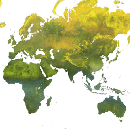
var dataset = ee.ImageCollection('NOAA/CDR/AVHRR/SR/V5')\n .filter(ee.Filter.date('2018-05-01', '2018-06-01'));\nvar surfaceReflectance = dataset.select('SREFL_CH1');\nvar surfaceReflectanceVis = {\n min: -1000.0,\n max: 9000.0,\n palette: ['003b02', '006a03', '008d05', '01be07', '01ff09', 'ffffff'],\n};\nMap.setCenter(52.48, 71.72, 1);\nMap.addLayer(surfaceReflectance, surfaceReflectanceVis, 'Surface Reflectance');\n```\n[Open in Code Editor](https://code.earthengine.google.com/?scriptPath=Examples:Datasets/NOAA/NOAA_CDR_AVHRR_SR_V5) \n[NOAA CDR AVHRR: Surface Reflectance, Version 5](/earth-engine/datasets/catalog/NOAA_CDR_AVHRR_SR_V5) \nThe NOAA Climate Data Record (CDR) of AVHRR Surface Reflectance contains gridded daily surface reflectance and brightness temperatures derived from the Advanced Very High Resolution Radiometer (AVHRR) sensors onboard seven NOAA polar orbiting satellites. The data are gridded at a resolution of 0.05° and computed globally over land surfaces. Known ... \nNOAA/CDR/AVHRR/SR/V5, avhrr,cdr,daily,land,noaa,reflectance,satellite-imagery,sr \n1981-06-24T00:00:00Z/2013-12-31T00:00:00Z \n-90 -180 90 180 \nGoogle Earth Engine \nhttps://developers.google.com/earth-engine/datasets\n\n- [https://doi.org/10.7289/V53776Z4](https://doi.org/https://www.ncei.noaa.gov/products/climate-data-records/surface-reflectance)\n- [https://doi.org/10.7289/V53776Z4](https://doi.org/https://developers.google.com/earth-engine/datasets/catalog/NOAA_CDR_AVHRR_SR_V5)"]]