Page Summary
-
The dataset is the daily Suomi NPP NASA VIIRS Burned Area (VNP64A1) Version 1 product, providing monthly, global gridded 500m data on burned area and quality information.
-
It is available from 2014-01-01 to 2019-01-01 and is provided by NASA LP DAAC at the USGS EROS Center.
-
The product utilizes 750m VIIRS imagery and active fire observations, employing VIIRS bands sensitive and insensitive to biomass burning to detect and differentiate fire-caused changes.
-
Key bands in the dataset include Burn_Date, Burn_Date_Uncertainty, QA, First_Day, and Last_Day, all at a 500-meter pixel size.
-
LP DAAC NASA data are freely accessible, with a request to cite the datasets in publications.
- Dataset Availability
- 2014-01-01T00:00:00Z–2019-01-01T00:00:00Z
- Dataset Producer
- NASA LP DAAC at the USGS EROS Center
- Cadence
- 30 Days
- Tags
Description
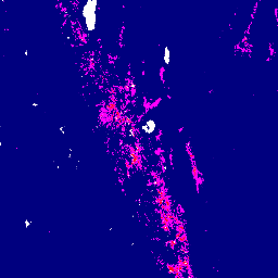
The daily Suomi National Polar-Orbiting Partnership (Suomi NPP) NASA Visible Infrared Imaging Radiometer Suite (VIIRS) Burned Area (VNP64A1) Version 1 data product is a monthly, global gridded 500m product containing per-pixel burned area and quality information. The VNP64 burned area mapping approach employs 750m VIIRS imagery coupled with 750m VIIRS active fire observations.
VIIRS bands that are both sensitive and insensitive to biomass burning are used to detect changes caused by fire and to differentiate them from other types of change.
Documentation:
Bands
Bands
Pixel size: 500 meters (all bands)
| Name | Units | Pixel Size | Description | ||||||||||||||||||||||||||||||||||||||||||||||||||||||||||||||||||||||||||||||||||||||||||||||||
|---|---|---|---|---|---|---|---|---|---|---|---|---|---|---|---|---|---|---|---|---|---|---|---|---|---|---|---|---|---|---|---|---|---|---|---|---|---|---|---|---|---|---|---|---|---|---|---|---|---|---|---|---|---|---|---|---|---|---|---|---|---|---|---|---|---|---|---|---|---|---|---|---|---|---|---|---|---|---|---|---|---|---|---|---|---|---|---|---|---|---|---|---|---|---|---|---|---|---|---|
Burn_Date |
500 meters | Ordinal day of burn (1-366) for each 500-m grid cell. |
|||||||||||||||||||||||||||||||||||||||||||||||||||||||||||||||||||||||||||||||||||||||||||||||||
Burn_Date_Uncertainty |
% | 500 meters | Estimated uncertainty in date of burn, in days. Unburned, unmapped, and water grid cells are masked out. |
||||||||||||||||||||||||||||||||||||||||||||||||||||||||||||||||||||||||||||||||||||||||||||||||
QA |
500 meters | Quality Assurance Indicators |
|||||||||||||||||||||||||||||||||||||||||||||||||||||||||||||||||||||||||||||||||||||||||||||||||
First_Day |
500 meters | First day of the year of reliable change detection |
|||||||||||||||||||||||||||||||||||||||||||||||||||||||||||||||||||||||||||||||||||||||||||||||||
Last_Day |
500 meters | Last day of the year of reliable change detection |
|||||||||||||||||||||||||||||||||||||||||||||||||||||||||||||||||||||||||||||||||||||||||||||||||
Terms of Use
Terms of Use
LP DAAC NASA data are freely accessible; however, when an author publishes these data or works based on the data, it is requested that the author cite the datasets within the text of the publication and include a reference to them in the reference list.
Citations
Please visit LP DAAC 'Citing Our Data' page for information on citing LP DAAC datasets.
DOIs
Explore with Earth Engine
Code Editor (JavaScript)
var image = ee.Image('NOAA/VIIRS/001/VNP64A1/2018_12_01');
var visualization = {
  bands: ['Last_Day'],
  min: 250.0,
  max: 320.0,
  palette: [
    '000080', '0000d9', '4000ff', '8000ff', '0080ff', '00ffff',
    '00ff80', '80ff00', 'daff00', 'ffff00', 'fff500', 'ffda00',
    'ffb000', 'ffa400', 'ff4f00', 'ff2500', 'ff0a00', 'ff00ff',
  ]
};

Map.setCenter(-119.13, 38.32, 8);
Map.addLayer(image, visualization, 'Last day');