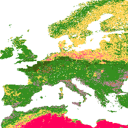
OpenLandMap Soil Texture Class (USDA System)
コレクションでコンテンツを整理
必要に応じて、コンテンツの保存と分類を行います。
説明
250 m の 6 つの土壌深度(0、10、30、60、100、200 cm)の土壌テクスチャ クラス(USDA システム)
R の soiltexture パッケージを使用して予測された土壌の粒径組成から導出されます。処理手順について詳しくは、こちらをご覧ください。南極は含まれません。
Earth Engine の外部で地図にアクセスして可視化するには、こちらのページをご覧ください。
LandGIS マップでバグ、アーティファクト、不整合が見つかった場合や、ご質問がある場合は、次のチャネルをご利用ください。
バンド
ピクセルサイズ
250 メートル
帯域
名前 |
ピクセルサイズ |
説明 |
b0 |
メートル
|
深さ 0 cm の土壌のテクスチャ クラス(USDA システム) |
b10 |
メートル
|
深さ 10 cm の土壌の土性クラス(USDA システム) |
b30 |
メートル
|
土壌のきめ(米国農務省の分類)の 30 cm の深さでの分類 |
b60 |
メートル
|
深さ 60 cm の土壌のテクスチャ クラス(USDA システム) |
b100 |
メートル
|
深さ 100 cm の土壌の土性クラス(米国農務省のシステム) |
b200 |
メートル
|
深さ 200 cm の土壌の土性クラス(USDA システム) |
b0 クラステーブル
値 |
色 |
説明 |
1 |
#d5c36b |
Cl |
2 |
#b96947 |
SiCl |
3 |
#9d3706 |
SaCl |
4 |
#ae868f |
ClLo |
5 |
#f86714 |
SiClLo |
6 |
#46d143 |
SaClLo |
7 |
#368f20 |
Lo |
8 |
#3e5a14 |
SiLo |
9 |
#ffd557 |
SaLo |
10 |
#fff72e |
スー |
11 |
#ff5a9d |
LoSa |
12 |
#ff005b |
土 |
b10 クラス表
値 |
色 |
説明 |
1 |
#d5c36b |
Cl |
2 |
#b96947 |
SiCl |
3 |
#9d3706 |
SaCl |
4 |
#ae868f |
ClLo |
5 |
#f86714 |
SiClLo |
6 |
#46d143 |
SaClLo |
7 |
#368f20 |
Lo |
8 |
#3e5a14 |
SiLo |
9 |
#ffd557 |
SaLo |
10 |
#fff72e |
スー |
11 |
#ff5a9d |
LoSa |
12 |
#ff005b |
土 |
b30 クラス表
値 |
色 |
説明 |
1 |
#d5c36b |
Cl |
2 |
#b96947 |
SiCl |
3 |
#9d3706 |
SaCl |
4 |
#ae868f |
ClLo |
5 |
#f86714 |
SiClLo |
6 |
#46d143 |
SaClLo |
7 |
#368f20 |
Lo |
8 |
#3e5a14 |
SiLo |
9 |
#ffd557 |
SaLo |
10 |
#fff72e |
スー |
11 |
#ff5a9d |
LoSa |
12 |
#ff005b |
土 |
b60 クラス表
値 |
色 |
説明 |
1 |
#d5c36b |
Cl |
2 |
#b96947 |
SiCl |
3 |
#9d3706 |
SaCl |
4 |
#ae868f |
ClLo |
5 |
#f86714 |
SiClLo |
6 |
#46d143 |
SaClLo |
7 |
#368f20 |
Lo |
8 |
#3e5a14 |
SiLo |
9 |
#ffd557 |
SaLo |
10 |
#fff72e |
スー |
11 |
#ff5a9d |
LoSa |
12 |
#ff005b |
土 |
b100 クラス テーブル
値 |
色 |
説明 |
1 |
#d5c36b |
Cl |
2 |
#b96947 |
SiCl |
3 |
#9d3706 |
SaCl |
4 |
#ae868f |
ClLo |
5 |
#f86714 |
SiClLo |
6 |
#46d143 |
SaClLo |
7 |
#368f20 |
Lo |
8 |
#3e5a14 |
SiLo |
9 |
#ffd557 |
SaLo |
10 |
#fff72e |
スー |
11 |
#ff5a9d |
LoSa |
12 |
#ff005b |
土 |
b200 クラス表
値 |
色 |
説明 |
1 |
#d5c36b |
Cl |
2 |
#b96947 |
SiCl |
3 |
#9d3706 |
SaCl |
4 |
#ae868f |
ClLo |
5 |
#f86714 |
SiClLo |
6 |
#46d143 |
SaClLo |
7 |
#368f20 |
Lo |
8 |
#3e5a14 |
SiLo |
9 |
#ffd557 |
SaLo |
10 |
#fff72e |
スー |
11 |
#ff5a9d |
LoSa |
12 |
#ff005b |
土 |
引用
Tomislav Hengl 氏。(2018)。250 m の 6 つの土壌深度(0、10、30、60、100、200 cm)の土壌粒度クラス(USDA システム)(バージョン v02)[データセット]。Zenodo。
10.5281/zenodo.1475451
Earth Engine で探索する
コードエディタ(JavaScript)
var dataset = ee.Image('OpenLandMap/SOL/SOL_TEXTURE-CLASS_USDA-TT_M/v02');
var visualization = {
bands: ['b0'],
min: 1.0,
max: 12.0,
palette: [
'd5c36b','b96947','9d3706','ae868f','f86714','46d143',
'368f20','3e5a14','ffd557','fff72e','ff5a9d','ff005b',
]
};
Map.centerObject(dataset);
Map.addLayer(dataset, visualization, 'Soil texture class (USDA system)');
コードエディタで開く
[null,null,[],[[["\u003cp\u003eThis dataset provides soil texture classes based on the USDA system for 6 different soil depths (0, 10, 30, 60, 100, and 200 cm).\u003c/p\u003e\n"],["\u003cp\u003eData is available at a 250-meter resolution and covers the period from 1950 to 2018, excluding Antarctica.\u003c/p\u003e\n"],["\u003cp\u003eSoil texture classes are derived using the soiltexture package in R, with detailed processing steps documented on GitLab.\u003c/p\u003e\n"],["\u003cp\u003eThe dataset can be accessed and visualized within Google Earth Engine or through OpenGeoHub for use outside of Earth Engine.\u003c/p\u003e\n"],["\u003cp\u003eThis dataset is licensed under CC-BY-SA-4.0 and was provided by EnvirometriX Ltd.\u003c/p\u003e\n"]]],[],null,["# OpenLandMap Soil Texture Class (USDA System)\n\nDataset Availability\n: 1950-01-01T00:00:00Z--2018-01-01T00:00:00Z\n\nDataset Provider\n:\n\n\n [EnvirometriX Ltd](https://doi.org/10.5281/zenodo.1475451)\n\nTags\n:\n [envirometrix](/earth-engine/datasets/tags/envirometrix) [opengeohub](/earth-engine/datasets/tags/opengeohub) [openlandmap](/earth-engine/datasets/tags/openlandmap) [soil](/earth-engine/datasets/tags/soil) [usda](/earth-engine/datasets/tags/usda) \ntexture \n\n#### Description\n\nSoil texture classes (USDA system) for 6 soil depths (0, 10, 30, 60, 100 and 200 cm) at 250 m\n\nDerived from predicted soil texture fractions using the soiltexture package in R.\nProcessing steps are described in detail [here](https://gitlab.com/openlandmap/global-layers/tree/master/soil).\nAntarctica is not included.\n\nTo access and visualize maps outside of Earth Engine, use [this page](https://opengeohub.org/about-openlandmap).\n\nIf you discover a bug, artifact or inconsistency in the LandGIS maps\nor if you have a question please use the following channels:\n\n- [Technical issues and questions about the code](https://gitlab.com/openlandmap/global-layers/issues)\n- [General questions and comments](https://disqus.com/home/forums/landgis/)\n\n### Bands\n\n\n**Pixel Size**\n\n250 meters\n\n**Bands**\n\n| Name | Pixel Size | Description |\n|--------|------------|--------------------------------------------------|\n| `b0` | meters | Soil texture class (USDA system) at 0 cm depth |\n| `b10` | meters | Soil texture class (USDA system) at 10 cm depth |\n| `b30` | meters | Soil texture class (USDA system) at 30 cm depth |\n| `b60` | meters | Soil texture class (USDA system) at 60 cm depth |\n| `b100` | meters | Soil texture class (USDA system) at 100 cm depth |\n| `b200` | meters | Soil texture class (USDA system) at 200 cm depth |\n\n**b0 Class Table**\n\n| Value | Color | Description |\n|-------|---------|-------------|\n| 1 | #d5c36b | Cl |\n| 2 | #b96947 | SiCl |\n| 3 | #9d3706 | SaCl |\n| 4 | #ae868f | ClLo |\n| 5 | #f86714 | SiClLo |\n| 6 | #46d143 | SaClLo |\n| 7 | #368f20 | Lo |\n| 8 | #3e5a14 | SiLo |\n| 9 | #ffd557 | SaLo |\n| 10 | #fff72e | Si |\n| 11 | #ff5a9d | LoSa |\n| 12 | #ff005b | Sa |\n\n**b10 Class Table**\n\n| Value | Color | Description |\n|-------|---------|-------------|\n| 1 | #d5c36b | Cl |\n| 2 | #b96947 | SiCl |\n| 3 | #9d3706 | SaCl |\n| 4 | #ae868f | ClLo |\n| 5 | #f86714 | SiClLo |\n| 6 | #46d143 | SaClLo |\n| 7 | #368f20 | Lo |\n| 8 | #3e5a14 | SiLo |\n| 9 | #ffd557 | SaLo |\n| 10 | #fff72e | Si |\n| 11 | #ff5a9d | LoSa |\n| 12 | #ff005b | Sa |\n\n**b30 Class Table**\n\n| Value | Color | Description |\n|-------|---------|-------------|\n| 1 | #d5c36b | Cl |\n| 2 | #b96947 | SiCl |\n| 3 | #9d3706 | SaCl |\n| 4 | #ae868f | ClLo |\n| 5 | #f86714 | SiClLo |\n| 6 | #46d143 | SaClLo |\n| 7 | #368f20 | Lo |\n| 8 | #3e5a14 | SiLo |\n| 9 | #ffd557 | SaLo |\n| 10 | #fff72e | Si |\n| 11 | #ff5a9d | LoSa |\n| 12 | #ff005b | Sa |\n\n**b60 Class Table**\n\n| Value | Color | Description |\n|-------|---------|-------------|\n| 1 | #d5c36b | Cl |\n| 2 | #b96947 | SiCl |\n| 3 | #9d3706 | SaCl |\n| 4 | #ae868f | ClLo |\n| 5 | #f86714 | SiClLo |\n| 6 | #46d143 | SaClLo |\n| 7 | #368f20 | Lo |\n| 8 | #3e5a14 | SiLo |\n| 9 | #ffd557 | SaLo |\n| 10 | #fff72e | Si |\n| 11 | #ff5a9d | LoSa |\n| 12 | #ff005b | Sa |\n\n**b100 Class Table**\n\n| Value | Color | Description |\n|-------|---------|-------------|\n| 1 | #d5c36b | Cl |\n| 2 | #b96947 | SiCl |\n| 3 | #9d3706 | SaCl |\n| 4 | #ae868f | ClLo |\n| 5 | #f86714 | SiClLo |\n| 6 | #46d143 | SaClLo |\n| 7 | #368f20 | Lo |\n| 8 | #3e5a14 | SiLo |\n| 9 | #ffd557 | SaLo |\n| 10 | #fff72e | Si |\n| 11 | #ff5a9d | LoSa |\n| 12 | #ff005b | Sa |\n\n**b200 Class Table**\n\n| Value | Color | Description |\n|-------|---------|-------------|\n| 1 | #d5c36b | Cl |\n| 2 | #b96947 | SiCl |\n| 3 | #9d3706 | SaCl |\n| 4 | #ae868f | ClLo |\n| 5 | #f86714 | SiClLo |\n| 6 | #46d143 | SaClLo |\n| 7 | #368f20 | Lo |\n| 8 | #3e5a14 | SiLo |\n| 9 | #ffd557 | SaLo |\n| 10 | #fff72e | Si |\n| 11 | #ff5a9d | LoSa |\n| 12 | #ff005b | Sa |\n\n### Terms of Use\n\n**Terms of Use**\n\n[CC-BY-SA-4.0](https://spdx.org/licenses/CC-BY-SA-4.0.html)\n\n### Citations\n\nCitations:\n\n- Tomislav Hengl. (2018). Soil texture classes (USDA system) for 6 soil depths (0, 10, 30, 60, 100 and 200 cm) at 250 m (Version v02) \\[Data set\\]. Zenodo.\n [10.5281/zenodo.1475451](https://doi.org/10.5281/zenodo.1475451)\n\n### DOIs\n\n- \u003chttps://doi.org/10.5281/zenodo.1475451\u003e\n\n### Explore with Earth Engine\n\n| **Important:** Earth Engine is a platform for petabyte-scale scientific analysis and visualization of geospatial datasets, both for public benefit and for business and government users. Earth Engine is free to use for research, education, and nonprofit use. To get started, please [register for Earth Engine access.](https://console.cloud.google.com/earth-engine)\n\n### Code Editor (JavaScript)\n\n```javascript\nvar dataset = ee.Image('OpenLandMap/SOL/SOL_TEXTURE-CLASS_USDA-TT_M/v02');\n\nvar visualization = {\n bands: ['b0'],\n min: 1.0,\n max: 12.0,\n palette: [\n 'd5c36b','b96947','9d3706','ae868f','f86714','46d143',\n '368f20','3e5a14','ffd557','fff72e','ff5a9d','ff005b',\n ]\n};\n\nMap.centerObject(dataset);\n\nMap.addLayer(dataset, visualization, 'Soil texture class (USDA system)');\n```\n[Open in Code Editor](https://code.earthengine.google.com/?scriptPath=Examples:Datasets/OpenLandMap/OpenLandMap_SOL_SOL_TEXTURE-CLASS_USDA-TT_M_v02) \n[OpenLandMap Soil Texture Class (USDA System)](/earth-engine/datasets/catalog/OpenLandMap_SOL_SOL_TEXTURE-CLASS_USDA-TT_M_v02) \nSoil texture classes (USDA system) for 6 soil depths (0, 10, 30, 60, 100 and 200 cm) at 250 m Derived from predicted soil texture fractions using the soiltexture package in R. Processing steps are described in detail here. Antarctica is not included. To access and visualize maps outside of ... \nOpenLandMap/SOL/SOL_TEXTURE-CLASS_USDA-TT_M/v02, envirometrix,opengeohub,openlandmap,soil,usda \n1950-01-01T00:00:00Z/2018-01-01T00:00:00Z \n-90 -180 90 180 \nGoogle Earth Engine \nhttps://developers.google.com/earth-engine/datasets\n\n- [https://doi.org/10.5281/zenodo.1475451](https://doi.org/https://doi.org/10.5281/zenodo.1475451)\n- [https://doi.org/10.5281/zenodo.1475451](https://doi.org/https://developers.google.com/earth-engine/datasets/catalog/OpenLandMap_SOL_SOL_TEXTURE-CLASS_USDA-TT_M_v02)"]]