Planet SkySat Public Ortho Imagery, RGB
コレクションでコンテンツを整理
必要に応じて、コンテンツの保存と分類を行います。
説明
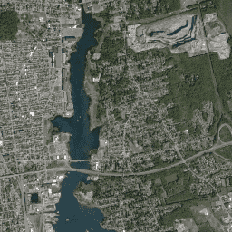
Planet labs Inc. の SkySat 衛星から取得されたこのデータは、2015 年に試験運用された「Skybox for Good ベータ版」プログラムのほか、さまざまなクライシス レスポンス イベントやその他のいくつかのプロジェクトのために収集されました。データは、5 バンドのマルチスペクトル/パン コレクションと、パンシャープニングされた RGB コレクションの両方で利用できます。
各画像の画像 ID には取得日時が含まれています。たとえば、画像 s01_20150304T080608Z は 2015 年 3 月 4 日午前 8 時 6 分(UTC)に取得されたものです。詳しくは、Planet Imagery のプロダクト仕様をご覧いただくか、Planet Imagery とアーカイブのサイトをご覧ください。
この RGB コレクションには、パンシャープニングされた 8 ビットの 3 つのバンドを含む画像が含まれています。解像度は 1 ピクセルあたり約 0.8 m です(斜め方向の画像では 1 m に近い値になります)。
バンド
ピクセルサイズ
0.8 メートル
帯域
名前 |
最小 |
最大 |
ピクセルサイズ |
波長 |
説明 |
R |
1*
|
255*
|
メートル
|
605 ~ 695nm |
赤 |
G |
1*
|
255*
|
メートル
|
515 ~ 595 nm |
緑 |
B |
1*
|
255*
|
メートル
|
450 ~ 515 nm |
青 |
* 推定最小値または最大値
画像プロパティ検出
画像プロパティ
名前 |
型 |
説明 |
catalogID |
STRING |
単一のコレクション イベントに対応する一意のカタログ ID。3 つの検出器すべてで同じです。 |
collectionEndTime |
STRING |
ISO 8601 形式の収集終了時刻(UTC)。 |
collectionStartTime |
STRING |
ISO 8601 形式の収集開始時刻(UTC)。 |
collectionType |
STRING |
「Strip」、「Point」、「Area」、「Path」。 |
productType |
STRING |
プロダクト レベルを識別するプロダクト タイプ(「Orthorectified Imagery」)。 |
productionID |
STRING |
このプロダクトのこのバージョンの ID。Singer/TileMill によって生成されます。 |
productionSystemVersion |
STRING |
なし |
resamplingMethod |
STRING |
補間されたピクセル値に使用されるメソッド。 |
satelliteAzimuthAngleMax |
DOUBLE |
収集時の衛星の最大方位角(度)。 |
satelliteAzimuthAngleMean |
DOUBLE |
収集時の衛星の平均方位角(度)。 |
satelliteAzimuthAngleMin |
DOUBLE |
収集時の衛星の最小方位角(度)。 |
satelliteElevationAngleMax |
DOUBLE |
収集時の衛星の最大仰角(度)。 |
satelliteElevationAngleMean |
DOUBLE |
収集時の衛星の平均仰角(度)。 |
satelliteElevationAngleMin |
DOUBLE |
収集時の衛星の最小仰角(度)。 |
satelliteName |
STRING |
宇宙船を識別する一意の名前。 |
snaptoAlignmentConfidence |
DOUBLE |
なし |
snaptoReferenceAssets |
STRING |
なし |
solarAzimuthAngle |
DOUBLE |
収集時の太陽の方位角。 |
solarElevationAngle |
DOUBLE |
収集時の太陽高度角。 |
terrainBlendEpoch |
DOUBLE |
なし |
利用規約
利用規約
このデータセットは、クリエイティブ・コモンズの表示ライセンス(CC-BY-4.0)に基づいて一般公開されています。
Earth Engine で探索する
コードエディタ(JavaScript)
var dataset = ee.ImageCollection('SKYSAT/GEN-A/PUBLIC/ORTHO/RGB');
var rgb = dataset.select(['R', 'G', 'B']);
var rgbVis = {
min: 11.0,
max: 190.0,
};
Map.setCenter(-70.892, 41.6555, 15);
Map.addLayer(rgb, rgbVis, 'RGB');
コードエディタで開く
[null,null,[],[[["\u003cp\u003eThis dataset contains high-resolution (0.8m) pansharpened RGB imagery from Planet SkySat satellites collected between July 3, 2014, and December 24, 2016.\u003c/p\u003e\n"],["\u003cp\u003eImagery was collected for the "Skybox for Good Beta" program, crisis response events, and other projects.\u003c/p\u003e\n"],["\u003cp\u003eThe dataset is available under the Creative Commons by Attribution license (CC-BY-4.0).\u003c/p\u003e\n"],["\u003cp\u003eEach image's asset ID includes acquisition date and time, enabling users to identify specific imagery.\u003c/p\u003e\n"],["\u003cp\u003eThe data is accessible through Google Earth Engine and is suitable for various research and analysis purposes.\u003c/p\u003e\n"]]],[],null,["# Planet SkySat Public Ortho Imagery, RGB\n\nDataset Availability\n: 2014-07-03T00:00:00Z--2016-12-24T00:00:00Z\n\nDataset Provider\n:\n\n\n [Planet Labs Inc.](https://www.planet.com/)\n\nTags\n:\n[highres](/earth-engine/datasets/tags/highres) [pansharpened](/earth-engine/datasets/tags/pansharpened) [planet](/earth-engine/datasets/tags/planet) [rgb](/earth-engine/datasets/tags/rgb) [satellite-imagery](/earth-engine/datasets/tags/satellite-imagery) [skysat](/earth-engine/datasets/tags/skysat) \n\n#### Description\n\nThis data from Planet labs Inc. SkySat satellites was collected for\nthe experimental \"Skybox for Good Beta\" program in 2015, as well as for\nvarious crisis response events and a few other projects. The data is\navailable in both a 5-band Multispectral/Pan collection, and a Pansharpened\nRGB collection.\n\nEach image's asset ID contains the acquisition date and time, for\nexample, image s01_20150304T080608Z was acquired on March 4, 2015 at\n08:06 Zulu (UTC). For more information, please see the\n[Planet Imagery Product Specifications](https://assets.planet.com/docs/Planet_Combined_Imagery_Product_Specs_letter_screen.pdf)\nand visit the\n[Planet Imagery and Archive](https://www.planet.com/products/planet-imagery/) site.\n\nThis RGB collection contains images with three pansharpened, 8-bit bands.\nThe resolution is approximately 0.8m per pixel (closer\nto 1m for off-nadir images).\n\n### Bands\n\n\n**Pixel Size**\n\n0.8 meters\n\n**Bands**\n\n| Name | Min | Max | Pixel Size | Wavelength | Description |\n|------|-----|-------|------------|------------|-------------|\n| `R` | 1\\* | 255\\* | meters | 605-695nm | Red |\n| `G` | 1\\* | 255\\* | meters | 515-595nm | Green |\n| `B` | 1\\* | 255\\* | meters | 450-515nm | Blue |\n\n\\* estimated min or max value\n\n### Image Properties\n\n**Image Properties**\n\n| Name | Type | Description |\n|-----------------------------|--------|------------------------------------------------------------------------------------------------|\n| catalogID | STRING | Unique catalog ID corresponding to a single collection event; same across all three detectors. |\n| collectionEndTime | STRING | ISO 8601 collection end time (UTC). |\n| collectionStartTime | STRING | ISO 8601 collection start time (UTC). |\n| collectionType | STRING | 'Strip', 'Point', 'Area', or 'Path'. |\n| productType | STRING | Product type identifying the product level ('Orthorectified Imagery'). |\n| productionID | STRING | ID of this version of this product, generated by Singer/TileMill. |\n| productionSystemVersion | STRING | N/A |\n| resamplingMethod | STRING | The method used for interpolated pixel values. |\n| satelliteAzimuthAngleMax | DOUBLE | Maximum satellite azimuth angle over the collection (degrees). |\n| satelliteAzimuthAngleMean | DOUBLE | Mean satellite azimuth angle over the collection (degrees). |\n| satelliteAzimuthAngleMin | DOUBLE | Minimum satellite azimuth angle over the collection (degrees). |\n| satelliteElevationAngleMax | DOUBLE | Maximum satellite elevation angle over the collection (degrees). |\n| satelliteElevationAngleMean | DOUBLE | Mean satellite elevation angle over the collection (degrees). |\n| satelliteElevationAngleMin | DOUBLE | Minimum satellite elevation angle over the collection (degrees). |\n| satelliteName | STRING | Unique name identifying the spacecraft. |\n| snaptoAlignmentConfidence | DOUBLE | N/A |\n| snaptoReferenceAssets | STRING | N/A |\n| solarAzimuthAngle | DOUBLE | Solar azimuth angle at the time of collection. |\n| solarElevationAngle | DOUBLE | Solar elevation angle at the time of collection. |\n| terrainBlendEpoch | DOUBLE | N/A |\n\n### Terms of Use\n\n**Terms of Use**\n\nThis dataset is made available publicly under the Creative Commons by\nAttribution license(CC-BY-4.0).\n\n### Citations\n\nCitations:\n\n- © \\\u003cyear\\\u003e Planet Labs Inc.\n\n### Explore with Earth Engine\n\n| **Important:** Earth Engine is a platform for petabyte-scale scientific analysis and visualization of geospatial datasets, both for public benefit and for business and government users. Earth Engine is free to use for research, education, and nonprofit use. To get started, please [register for Earth Engine access.](https://console.cloud.google.com/earth-engine)\n\n### Code Editor (JavaScript)\n\n```javascript\nvar dataset = ee.ImageCollection('SKYSAT/GEN-A/PUBLIC/ORTHO/RGB');\nvar rgb = dataset.select(['R', 'G', 'B']);\nvar rgbVis = {\n min: 11.0,\n max: 190.0,\n};\nMap.setCenter(-70.892, 41.6555, 15);\nMap.addLayer(rgb, rgbVis, 'RGB');\n```\n[Open in Code Editor](https://code.earthengine.google.com/?scriptPath=Examples:Datasets/SKYSAT/SKYSAT_GEN-A_PUBLIC_ORTHO_RGB) \n[Planet SkySat Public Ortho Imagery, RGB](/earth-engine/datasets/catalog/SKYSAT_GEN-A_PUBLIC_ORTHO_RGB) \nThis data from Planet labs Inc. SkySat satellites was collected for the experimental \"Skybox for Good Beta\" program in 2015, as well as for various crisis response events and a few other projects. The data is available in both a 5-band Multispectral/Pan collection, and a Pansharpened RGB collection. Each image's ... \nSKYSAT/GEN-A/PUBLIC/ORTHO/RGB, highres,pansharpened,planet,rgb,satellite-imagery,skysat \n2014-07-03T00:00:00Z/2016-12-24T00:00:00Z \n-70 -180 53 180 \nGoogle Earth Engine \nhttps://developers.google.com/earth-engine/datasets\n\n- [](https://doi.org/https://www.planet.com/)\n- [](https://doi.org/https://developers.google.com/earth-engine/datasets/catalog/SKYSAT_GEN-A_PUBLIC_ORTHO_RGB)"]]