-
NAIP: 米国農業画像プログラム
米国本土の農業生育期に撮影される航空写真は、
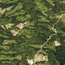
National Agriculture Imagery Program(NAIP)によって取得されます。NAIP プロジェクトは、利用可能な資金と画像取得サイクルに基づいて毎年契約されます。2003 年以降、NAIP は 5 年ごとに取得されています。2008 年は 農業 高解像度 画像 正射画像 usda -
NEON RGB カメラ画像
高解像度の赤、緑、青(RGB)オルソ補正カメラ画像をモザイク化し、最近傍再サンプリングを使用して固定された均一な空間グリッドに出力します。空間解像度は 0.1 m です。このデジタルカメラは、NEON 航空観測プラットフォーム(AOP)に搭載されている一連の機器の一部であり、次のような機器も含まれています。 airborne forest highres neon neon-prod-earthengine orthophoto -
Planet SkySat 公開オルソ画像、マルチスペクトル
Planet Labs Inc. の SkySat 衛星から収集されたこのデータは、2015 年の試験運用版「Skybox for Good ベータ版」プログラム、さまざまな危機対応イベント、その他のプロジェクトのために収集されました。このデータは、5 バンドのマルチスペクトル/パン コレクションと … 高解像度 マルチスペクトル パンシャープ化 惑星 衛星画像 skysat -
Planet SkySat 公開オルソ画像、RGB
Planet Labs Inc. の SkySat 衛星から収集されたこのデータは、2015 年の試験運用版「Skybox for Good ベータ版」プログラム、さまざまな危機対応イベント、その他のプロジェクトのために収集されました。このデータは、5 バンドのマルチスペクトル/パン コレクションと … highres pansharpened planet rgb satellite-imagery skysat
Datasets tagged highres in Earth Engine
[null,null,[],[[["\u003cp\u003ePlanet SkySat imagery offers high-resolution multispectral and RGB data, primarily collected for the "Skybox for Good Beta" program, crisis response, and other projects.\u003c/p\u003e\n"],["\u003cp\u003eNAIP provides aerial imagery of the continental U.S. during agricultural growing seasons, acquired on a 5-year cycle since 2003, focusing on agricultural land.\u003c/p\u003e\n"],["\u003cp\u003eNEON RGB Camera Imagery comprises high-resolution (0.1m) orthorectified images collected by the NEON Airborne Observation Platform, often used for forest and ecological studies.\u003c/p\u003e\n"]]],["Planet Labs Inc. SkySat satellites collected data for the \"Skybox for Good Beta\" program in 2015 and crisis response events. This data is available in 5-band Multispectral/Pan and RGB collections. The National Agriculture Imagery Program (NAIP) acquires aerial imagery during U.S. agricultural growing seasons, beginning on a 5-year cycle in 2003. High-resolution RGB camera images from the NEON Airborne Observation Platform (AOP) are also available, featuring 0.1m spatial resolution.\n"],null,["# Datasets tagged highres in Earth Engine\n\n-\n\n |---------------------------------------------------------------------------------------------------------------------------------------------------------------------------------------------------------------------------------------------------------------------------------------------------------------------|\n | [### NAIP: National Agriculture Imagery Program](/earth-engine/datasets/catalog/USDA_NAIP_DOQQ) |\n | The National Agriculture Imagery Program (NAIP) acquires aerial imagery during the agricultural growing seasons in the continental U.S. NAIP projects are contracted each year based upon available funding and the imagery acquisition cycle. Beginning in 2003, NAIP was acquired on a 5-year cycle. 2008 was ... |\n | [agriculture](/earth-engine/datasets/tags/agriculture) [highres](/earth-engine/datasets/tags/highres) [imagery](/earth-engine/datasets/tags/imagery) [orthophotos](/earth-engine/datasets/tags/orthophotos) [usda](/earth-engine/datasets/tags/usda) |\n\n-\n\n |-------------------------------------------------------------------------------------------------------------------------------------------------------------------------------------------------------------------------------------------------------------------------------------------------------------------------|\n | [### NEON RGB Camera Imagery](/earth-engine/datasets/catalog/projects_neon-prod-earthengine_assets_RGB_001) |\n | High resolution Red-Green-Blue (RGB) orthorectified camera images mosaicked and output onto a fixed, uniform spatial grid using nearest-neighbor resampling; spatial resolution is 0.1 m. The digital camera is part of a suite of instruments on the NEON Airborne Observation Platform (AOP) that also includes a ... |\n | [airborne](/earth-engine/datasets/tags/airborne) [forest](/earth-engine/datasets/tags/forest) [highres](/earth-engine/datasets/tags/highres) [neon](/earth-engine/datasets/tags/neon) [neon-prod-earthengine](/earth-engine/datasets/tags/neon-prod-earthengine) [orthophoto](/earth-engine/datasets/tags/orthophoto) |\n\n-\n\n |---------------------------------------------------------------------------------------------------------------------------------------------------------------------------------------------------------------------------------------------------------------------------------------------------------------------------------|\n | [### Planet SkySat Public Ortho Imagery, Multispectral](/earth-engine/datasets/catalog/SKYSAT_GEN-A_PUBLIC_ORTHO_MULTISPECTRAL) |\n | This data from Planet labs Inc. SkySat satellites was collected for the experimental \"Skybox for Good Beta\" program in 2015, as well as for various crisis response events and a few other projects. The data is available in both a 5-band Multispectral/Pan collection, and a ... |\n | [highres](/earth-engine/datasets/tags/highres) [multispectral](/earth-engine/datasets/tags/multispectral) [pansharpened](/earth-engine/datasets/tags/pansharpened) [planet](/earth-engine/datasets/tags/planet) [satellite-imagery](/earth-engine/datasets/tags/satellite-imagery) [skysat](/earth-engine/datasets/tags/skysat) |\n\n-\n\n |-------------------------------------------------------------------------------------------------------------------------------------------------------------------------------------------------------------------------------------------------------------------------------------------------------------|\n | [### Planet SkySat Public Ortho Imagery, RGB](/earth-engine/datasets/catalog/SKYSAT_GEN-A_PUBLIC_ORTHO_RGB) |\n | This data from Planet labs Inc. SkySat satellites was collected for the experimental \"Skybox for Good Beta\" program in 2015, as well as for various crisis response events and a few other projects. The data is available in both a 5-band Multispectral/Pan collection, and a ... |\n | [highres](/earth-engine/datasets/tags/highres) [pansharpened](/earth-engine/datasets/tags/pansharpened) [planet](/earth-engine/datasets/tags/planet) [rgb](/earth-engine/datasets/tags/rgb) [satellite-imagery](/earth-engine/datasets/tags/satellite-imagery) [skysat](/earth-engine/datasets/tags/skysat) |"]]