Page Summary
-
WRI has stopped updating FORMA alerts to simplify Global Forest Watch and reduce redundancy, as Terra-i and GLAD were more frequently used and Terra-i performed better globally.
-
FORMA alerts are detected using MODIS NDVI and FIRMS data, with models trained using Hansen annual tree cover loss data.
-
The minimum threshold for a FORMA alert is 25% pixel clearing, though thresholds vary by ecogroup.
-
This dataset contains raw FORMA data, updated daily after new MODIS FIRMS data is available.
-
The dataset provides percentage of clearing for different accumulation periods in its bands.
- Dataset Availability
- 2017-04-08T00:00:00Z–2019-05-18T00:00:00Z
- Dataset Producer
- World Resources Institute / Global Forest Watch
- Tags
Description
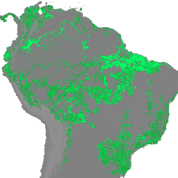
NOTE from WRI: WRI decided to stop updating FORMA alerts. The goal was to simplify the Global Forest Watch user experience and reduce redundancy. We found that Terra-i and GLAD were more frequently used. Moreover, using GLAD as a standard, found that Terra-i outperformed FORMA globally.
FORMA alerts are detected using a combination of two MODIS products: NDVI (Normalized Difference Vegetation Index) and FIRMS (Fires Information for Resource Management System). NDVI updates are processed every 16 days, while fire updates are processed daily. Models are developed individually for each ecogroup to relate the two inputs to the area of clearing, using the Hansen annual tree cover loss data to train the model. The minimum threshold to qualify as an alert is 25% of the pixel cleared, though thresholds vary by ecogroup to minimize false positives. Here is an example script for a quick introduction to the FORMA datasets.
The images in this ImageCollection contain the raw FORMA data calculated after new MODIS FIRMS data becomes available, approximately every day.
Each band gives a percentage of clearing (from 0 to 100) for different accumulation periods. "N" is the number of days between the latest FIRMS update and the previous NDVI update. N is given by the 'date_delta' property.
Bands
Bands
Pixel size: 250 meters (all bands)
| Name | Units | Min | Max | Pixel Size | Description |
|---|---|---|---|---|---|
nday |
% | 0 | 100 | 250 meters | Percentage of clearing in the last N days |
delta_nday |
% | 0 | 100 | 250 meters | Percentage of clearing in the last 96+N days |
near_term_delta_nday |
% | 0 | 100 | 250 meters | Percentage of clearing in the last 32+N days |
Image Properties
Image Properties
| Name | Type | Description |
|---|---|---|
| year | INT | Year of the most recent data included in the dataset |
| date | STRING | Date, in "YYYY-MM-DD" format, of the last MODIS FIRMS data included in this dataset |
| date_delta | INT | The number of days between date and previous_biweekly_date |
| previous_biweekly | INT | The biweekly (every 16 days) period of the year associated with the latest MODIS NDVI |
| previous_biweekly_date | STRING | The date associated with the latest MODIS NDVI update |
Terms of Use
Terms of Use
The FORMA datasets are available without restriction on use or distribution. WRI does request that the user give proper attribution and identify WRI and GFW, where applicable, as the source of the data.
Explore with Earth Engine
Code Editor (JavaScript)
var dataset = ee.ImageCollection('WRI/GFW/FORMA/raw_output_firms')
                  .filter(ee.Filter.date('2018-08-01', '2018-08-15'));
var percentageOfClearing = dataset.select('nday');
var visParams = {
  min: 0.0,
  max: 0.01,
};
Map.setCenter(26, -8, 3);
Map.addLayer(percentageOfClearing, visParams, 'Percentage of clearing');