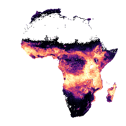
-
iSDAsoil 有効陽イオン交換容量
有効な陽イオン交換容量の予測平均と標準偏差(土壌深度 0 ~ 20 cm、20 ~ 50 cm)。ピクセル値は exp(x/10)-1 で元に戻す必要があります。密集したジャングルがある地域(一般的に中央アフリカ上空)では、モデルの精度が低いため、バンディング(ストライプ)などのアーティファクトが発生します。 アフリカ アルミニウム isda 土壌 -
iSDAsoil 総炭素量
土壌深度 0 ~ 20 cm と 20 ~ 50 cm の総炭素量、予測平均値と標準偏差。ピクセル値は、exp(x/10)-1 で元に戻す必要があります。密林が広がる地域(一般的には中央アフリカ)では、モデルの精度が低いため、バンディング(ストライプ)などのアーティファクトが発生する可能性があります。 アフリカ アルミニウム isda 土壌 -
iSDAsoil USDA テクスチャクラス
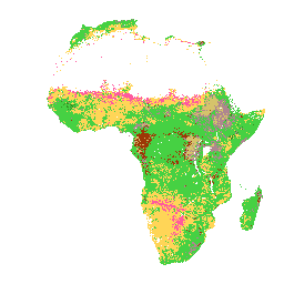
土壌の深さ 0 ~ 20 cm と 20 ~ 50 cm の USDA テクスチャ クラス。密林の多い地域(一般的には中央アフリカ)では、モデルの精度が低いため、バンディング(ストライプ)などのアーティファクトが表示されることがあります。土壌特性の予測は、Innovative Solutions for Decision ... アフリカ アルミニウム isda 土壌 -
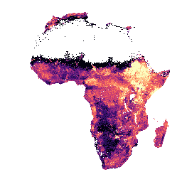
iSDAsoil 抽出可能アルミニウム
土壌深度 0 ~ 20 cm と 20 ~ 50 cm における抽出可能なアルミニウムの予測平均と標準偏差。ピクセル値は、exp(x/10)-1 で元に戻す必要があります。土壌特性の予測は、Innovative Solutions for Decision Agriculture Ltd.(iSDA)によって、機械学習と組み合わせた 30 m ピクセルサイズで行われました。 アフリカ アルミニウム isda 土壌
Datasets tagged aluminium in Earth Engine
[null,null,[],[[["\u003cp\u003eThis dataset provides soil property predictions for Africa at 30m pixel size, including extractable aluminum, total carbon, effective cation exchange capacity, and USDA texture class.\u003c/p\u003e\n"],["\u003cp\u003ePredictions are available for two soil depths: 0-20 cm and 20-50 cm, and include predicted mean and standard deviation.\u003c/p\u003e\n"],["\u003cp\u003eData is back-transformed using exp(x/10)-1 for analysis.\u003c/p\u003e\n"],["\u003cp\u003eModel accuracy is lower in dense jungle areas (generally over central Africa), potentially leading to artifacts like banding.\u003c/p\u003e\n"],["\u003cp\u003ePredictions were generated by Innovative Solutions for Decision Agriculture Ltd.(iSDA) using machine learning techniques.\u003c/p\u003e\n"]]],["iSDA provides soil data for Africa at 30m pixel size, focusing on depths of 0-20 cm and 20-50 cm. This includes extractable aluminium, total carbon, effective cation exchange capacity, and USDA texture class. Data includes predicted mean and standard deviation. Pixel values require back-transformation using the formula exp(x/10)-1. Model accuracy may be low in dense jungle areas, potentially showing banding artifacts. Machine learning is employed for soil property predictions.\n"],null,["# Datasets tagged aluminium in Earth Engine\n\n-\n\n |-----------------------------------------------------------------------------------------------------------------------------------------------------------------------------------------------------------------------------------------------------------------------------------------------------------------|\n | [### iSDAsoil Effective Cation Exchange Capacity](/earth-engine/datasets/catalog/ISDASOIL_Africa_v1_cation_exchange_capacity) |\n | Effective Cation Exchange Capacity predicted mean and standard deviation at soil depths of 0-20 cm and 20-50 cm, Pixel values must be back-transformed with exp(x/10)-1. In areas of dense jungle (generally over central Africa), model accuracy is low and therefore artifacts such as banding (striping) ... |\n | [africa](/earth-engine/datasets/tags/africa) [aluminium](/earth-engine/datasets/tags/aluminium) [isda](/earth-engine/datasets/tags/isda) [soil](/earth-engine/datasets/tags/soil) |\n\n-\n\n |-----------------------------------------------------------------------------------------------------------------------------------------------------------------------------------------------------------------------------------------------------------------------------------------------------|\n | [### iSDAsoil Total Carbon](/earth-engine/datasets/catalog/ISDASOIL_Africa_v1_carbon_total) |\n | Total carbon at soil depths of 0-20 cm and 20-50 cm, predicted mean and standard deviation. Pixel values must be back-transformed with exp(x/10)-1. In areas of dense jungle (generally over central Africa), model accuracy is low and therefore artifacts such as banding (striping) might be ... |\n | [africa](/earth-engine/datasets/tags/africa) [aluminium](/earth-engine/datasets/tags/aluminium) [isda](/earth-engine/datasets/tags/isda) [soil](/earth-engine/datasets/tags/soil) |\n\n-\n\n |-------------------------------------------------------------------------------------------------------------------------------------------------------------------------------------------------------------------------------------------------------------------------------------------|\n | [### iSDAsoil USDA Texture Class](/earth-engine/datasets/catalog/ISDASOIL_Africa_v1_texture_class) |\n | USDA Texture Class at soil depths of 0-20 cm and 20-50 cm. In areas of dense jungle (generally over central Africa), model accuracy is low and therefore artifacts such as banding (striping) might be seen. Soil property predictions were made by Innovative Solutions for Decision ... |\n | [africa](/earth-engine/datasets/tags/africa) [aluminium](/earth-engine/datasets/tags/aluminium) [isda](/earth-engine/datasets/tags/isda) [soil](/earth-engine/datasets/tags/soil) |\n\n-\n\n |---------------------------------------------------------------------------------------------------------------------------------------------------------------------------------------------------------------------------------------------------------------------------------------------------------------------|\n | [### iSDAsoil extractable Aluminium](/earth-engine/datasets/catalog/ISDASOIL_Africa_v1_aluminium_extractable) |\n | Extractable aluminium at soil depths of 0-20 cm and 20-50 cm, predicted mean and standard deviation. Pixel values must be back-transformed with exp(x/10)-1. Soil property predictions were made by Innovative Solutions for Decision Agriculture Ltd. (iSDA) at 30 m pixel size using machine learning coupled ... |\n | [africa](/earth-engine/datasets/tags/africa) [aluminium](/earth-engine/datasets/tags/aluminium) [isda](/earth-engine/datasets/tags/isda) [soil](/earth-engine/datasets/tags/soil) |"]]