Page Summary
-
Several datasets provide burned area information at global and regional scales with varying spatial and temporal resolutions.
-
These datasets utilize different satellite instruments like MODIS and VIIRS and employ various mapping approaches.
-
Information on burned area and quality is available in monthly products, with some datasets also offering ancillary data.
-
The datasets are relevant for topics including fire, climate change, change detection, and wildfire risk.
-
FireCCI51: MODIS Fire_cci Burned Area Pixel Product, Version 5.1
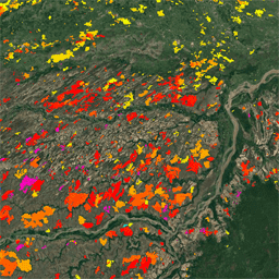
The MODIS Fire_cci Burned Area pixel product version 5.1 (FireCCI51) is a monthly global ~250m spatial resolution dataset containing information on burned area as well as ancillary data. It is based on surface reflectance in the Near Infrared (NIR) band from the MODIS instrument onboard … burn cci climate-change copernicus esa fire -
MCD64A1.061 MODIS Burned Area Monthly Global 500m
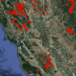
The Terra and Aqua combined MCD64A1 Version 6.1 Burned Area data product is a monthly, global gridded 500m product containing per-pixel burned-area and quality information. The MCD64A1 burned-area mapping approach employs 500m MODIS Surface Reflectance imagery coupled with 1km MODIS active fire observations. The algorithm … burn change-detection fire geophysical global mcd64a1 -
VNP64A1.002: Burned Area Monthly L4 Global 500m SIN Grid

The daily Suomi National Polar-Orbiting Partnership (Suomi NPP) NASA Visible Infrared Imaging Radiometer Suite (VIIRS) Burned Area (VNP64A1) Version 2 data product is a monthly, global gridded 500m product containing per-pixel burned area and quality information. The VNP64 burned area mapping approach employs 750m VIIRS … burn change-detection fire land nasa surface -
Wildfire Risk to Communities v0
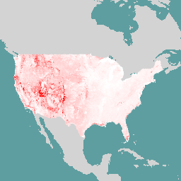
This dataset depicts components of wildfire risk for all lands in the United States that: 1) are landscape-wide (i.e., measurable at every pixel across the landscape); and 2) represent in situ risk - risk at the location where the adverse effects take place on the … burn fire usda wildfire