-
MERIT Hydro:全球水文数据集
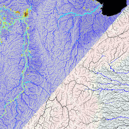
MERIT Hydro 是一张新的全球水流方向图,分辨率为 3 角秒(赤道处约为 90 米),基于 MERIT DEM 海拔数据和水体数据集(G1WBM、GSWO 和 OpenStreetMap)的 1.0.3 版得出。MERIT Hydro 包含新 … 的输出 dem elevation flow-direction hand hydrography hydrosheds -
MERIT Hydro:补充可视化图层

MERIT Hydro 的补充可视化图层 dem elevation flow-direction hand hydrography hydrosheds
Datasets tagged flow-direction in Earth Engine
[null,null,[],[],["MERIT Hydro offers a global flow direction map with a 3 arc-second resolution, derived from MERIT DEM elevation data and water body datasets (G1WBM, GSWO, OpenStreetMap). It utilizes elevation, flow-direction, and hydrography data. It offers supplementary visualization layers that share the same data origins and tag categories, offering additional tools for understanding the hydrography data. The dataset focuses on mapping water flow direction globally.\n"]]