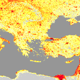
-
乌克兰的 LandScan 高清数据(2022 年 1 月)
LandScan 高清 (HD) 提供网格化人口估算数据,分辨率为 3 弧秒(约 100 米)。每个 LandScan HD 单元格的值表示环境(即 24 小时平均值)人口数估算值。这样一来,数据便可捕获用户在整个课程期间的所有潜在活动空间… 地貌 人口 -
LandScan 人口数据(全球,1 公里)
LandScan 数据集由橡树岭国家实验室 (ORNL) 提供,是一个全面且高分辨率的全球人口分布数据集,可作为各种应用的宝贵资源。LandScan 利用最先进的空间建模技术和高级地理空间数据源,提供详细的… community-dataset demography landscan population sat-io
Datasets tagged landscan in Earth Engine
[null,null,[],[[["\u003cp\u003eLandScan HD provides high-resolution (approximately 100m) gridded population estimates for Ukraine, reflecting the average daily population distribution.\u003c/p\u003e\n"],["\u003cp\u003eLandScan Global offers a 1km resolution global population distribution dataset using advanced spatial modeling and various data sources.\u003c/p\u003e\n"],["\u003cp\u003eBoth datasets are valuable resources for diverse applications requiring population data, with the former focusing on Ukraine and the latter providing a global perspective.\u003c/p\u003e\n"]]],["LandScan HD provides population estimates for Ukraine at a 3 arc-second (~100m) resolution, representing a 24-hour average population count per cell. LandScan Global, from Oak Ridge National Laboratory, offers a high-resolution global population distribution dataset. It utilizes spatial modeling and geospatial data to provide detailed population information for diverse applications. Both datasets are tagged with \"landscan\" and \"population,\" indicating their focus on population distribution analysis.\n"],null,["# Datasets tagged landscan in Earth Engine\n\n-\n\n |----------------------------------------------------------------------------------------------------------------------------------------------------------------------------------------------------------------------------------------------------------------------------------------------------------------------|\n | [### LandScan High Definition Data for Ukraine, January 2022](/earth-engine/datasets/catalog/DOE_ORNL_LandScan_HD_Ukraine_202201) |\n | LandScan High Definition (HD) provides gridded population estimates at 3 arc-second (\\~100m) resolution. Values for each LandScan HD cell represent an ambient (i.e. 24 hour average) population count estimate. In this way, the data capture the full potential activity space of people throughout the course ... |\n | [landscan](/earth-engine/datasets/tags/landscan) [population](/earth-engine/datasets/tags/population) |\n\n-\n\n |-----------------------------------------------------------------------------------------------------------------------------------------------------------------------------------------------------------------------------------------------------------------------------------------------------------------------------------------------------------------|\n | [### LandScan Population Data Global 1km](/earth-engine/datasets/catalog/projects_sat-io_open-datasets_ORNL_LANDSCAN_GLOBAL) |\n | The LandScan dataset, provided by the Oak Ridge National Laboratory (ORNL), offers a comprehensive and high-resolution global population distribution dataset that serves as a valuable resource for a wide range of applications. Leveraging state-of-the-art spatial modeling techniques and advanced geospatial data sources, LandScan provides detailed ... |\n | [community-dataset](/earth-engine/datasets/tags/community-dataset) [demography](/earth-engine/datasets/tags/demography) [landscan](/earth-engine/datasets/tags/landscan) [population](/earth-engine/datasets/tags/population) [sat-io](/earth-engine/datasets/tags/sat-io) |"]]