-
AG100: ASTER Global Emissivity Dataset 100-meter V003

Advanced Spaceborne Thermal Emission and Reflection Radiometer Global Emissivity Database(ASTER-GED)は、カリフォルニア工科大学の NASA(アメリカ航空宇宙局)ジェット推進研究所(JPL)によって開発されました。このプロダクトには、5 つの ASTER 熱赤外線バンドすべての平均放射率と標準偏差が含まれています。 aster elevation emissivity geophysical infrared jpl -
ASTER L1T 放射輝度

注: ASTER 機器の技術的な問題により、2024 年 11 月 28 日から 2025 年 1 月 16 日までの間、データ収集にギャップがあります。詳しくは、USGS のお知らせをご覧ください。Advanced Spaceborne Thermal Emission and Reflection Radiometer(ASTER)は、… aster imagery nasa nir radiance satellite-imagery -
FIRMS: Fire Information for Resource Management System
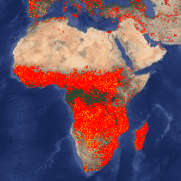
Earth Engine 版の Fire Information for Resource Management System(FIRMS)データセットには、ラスタライズされた形式の LANCE 火災検知プロダクトが含まれています。ほぼリアルタイム(NRT)の火災発生場所は、標準の MODIS MOD14/MYD14 火災と熱異常プロダクトを使用して LANCE によって処理されます。各 … eosdis fire firms geophysical hotspot lance -
VJ114IMGTDL_NRT 毎日ラスタ: VIIRS(NOAA-20)バンド 375m の活発な火災

NOAA-20(JPSS-1)可視赤外撮像機放射計(VIIRS)の火災検出プロダクトは、機器の公称解像度 375 m のデータに基づいています。他の粗い解像度(1 km 以上)の衛星火災検出プロダクトと比較して、375 m のデータが改善されたことで、比較的小さな火災に対する応答性が向上しました。 eosdis fire firms geophysical hotspot lance -
VNP14IMGTDL_NRT Daily Raster: VIIRS (S-NPP) Band 375m Active Fire

Suomi NPP 可視赤外線画像放射計スイート(VIIRS)アクティブ火災検出プロダクトは、機器の公称解像度 375 m のデータに基づいています。他の粗い解像度(1 km 以上)の衛星火災検出プロダクトと比較して、375 m のデータが改善されたことで、比較的小さな火災に対する応答性が向上しました。 eosdis fire firms geophysical hotspot lance
Datasets tagged thermal in Earth Engine
[null,null,[],[],[]]