-
2000 グリーンランド モザイク - グリーンランド氷地図プロジェクト(GIMP)
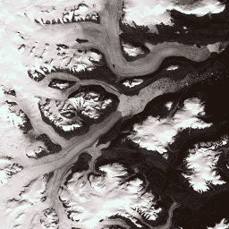
このデータセットは、1999 年から 2002 年の Landsat 7 ETM+ と RADARSAT-1 SAR 画像から得られた、グリーンランド氷床の 15 m 解像度の完全な画像モザイクを提供します。これらの方法には、画像クラウド マスキング、パンシャープニング、画像サンプリングとサイズ変更の組み合わせなどがあります。 arctic gimp greenland imagery nasa polar -
ASTER L1T 輝度
注: ASTER の機器の技術的な問題により、2024 年 11 月 28 日から 2025 年 1 月 16 日までの期間はデータ収集が中断されています。詳しくは、USGS のお知らせをご覧ください。高度な宇宙搭載熱放射反射放射計(ASTER)は、次のようなマルチスペクトル画像装置です。 aster 画像 nasa nir radiance satellite-imagery -
CCNL: DMSP-OLS の夜間照明データセット(1992 ~ 2013)v1 の整合性と修正
一貫性と補正を加えた夜間照明(CCNL)データセットは、国防気象プログラム(DMSP)運用ラインスキャン システム(OLS)バージョン 4 の再処理バージョンです。一連の方法を使用して、年ごとの不整合、飽和、ブルーミングの影響を軽減し、データを改善しました。 dmsp eog imagery lights nighttime ols -
DMSP OLS: グローバル放射力補正ナイトライト バージョン 4、防衛気象プログラム運用ラインスキャン システム
防衛気象プログラム(DMSP)オペレーション ラインスキャン システム(OLS)は、夜間に可視光と近赤外線(VNIR)の放射源を検出できる独自の機能を備えています。このコレクションには、センサーの飽和状態のない世界中の夜間照明の画像が含まれています。通常、センサーは高ゲイン設定で動作し、次のことを可能にします。 dmsp eog imagery lights nighttime ols -
DMSP OLS: 夜間照明の時系列データ バージョン 4、防衛気象プログラム運用ラインスキャン システム
防衛気象プログラム(DMSP)オペレーション ラインスキャン システム(OLS)は、夜間に可視光と近赤外線(VNIR)の放射源を検出できる独自の機能を備えています。DMSP-OLS ナイトライト タイムシリーズのバージョン 4 は、利用可能なすべてのアーカイブ DMSP-OLS スムーズ解像度を使用して作成された雲のない合成画像で構成されています。 dmsp eog imagery lights nighttime ols -
NAIP: 国家農業画像プログラム
米国本土の農業生育期に撮影される航空写真は、National Agriculture Imagery Program(NAIP)によって取得されます。NAIP プロジェクトは、利用可能な資金と画像取得サイクルに基づいて毎年契約されます。2003 年以降、NAIP は 5 年ごとに取得されています。2008 年は 農業 高解像度 画像 正射画像 usda
Datasets tagged imagery in Earth Engine
[null,null,[],[[["\u003cp\u003eThe Advanced Spaceborne Thermal Emission and Reflection Radiometer (ASTER) dataset provides multispectral imagery from the visible to the thermal infrared spectrum, collected by NASA's Terra spacecraft.\u003c/p\u003e\n"],["\u003cp\u003eThe Consistent and Corrected Nighttime Lights (CCNL) dataset offers reprocessed nighttime lights data from the Defense Meteorological Program (DMSP) Operational Line-Scan System (OLS), addressing inconsistencies and improving data quality.\u003c/p\u003e\n"],["\u003cp\u003eThe National Agriculture Imagery Program (NAIP) acquires high-resolution aerial imagery of the continental U.S. during agricultural growing seasons, with acquisitions typically on a 5-year cycle.\u003c/p\u003e\n"],["\u003cp\u003eThe Defense Meteorological Program (DMSP) Operational Line-Scan System (OLS) datasets provide global nighttime lights images, including radiance-calibrated and time series versions, enabling the detection of visible and near-infrared emission sources at night.\u003c/p\u003e\n"],["\u003cp\u003eThe 2000 Greenland Mosaic from the Greenland Ice Mapping Project (GIMP) offers a complete 15 m resolution image mosaic of the Greenland ice sheet derived from Landsat 7 ETM+ and RADARSAT-1 SAR imagery.\u003c/p\u003e\n"]]],[],null,["# Datasets tagged imagery in Earth Engine\n\n-\n\n |-----------------------------------------------------------------------------------------------------------------------------------------------------------------------------------------------------------------------------------------------------------------------------------------|\n | [### 2000 Greenland Mosaic - Greenland Ice Mapping Project (GIMP)](/earth-engine/datasets/catalog/OSU_GIMP_2000_IMAGERY_MOSAIC) |\n | This dataset provides a complete 15 m resolution image mosaic of the Greenland ice sheet derived from Landsat 7 ETM+ and RADARSAT-1 SAR imagery from the years 1999 to 2002. The methods include a combination of image cloud masking, pan sharpening, image sampling and resizing, ... |\n | [arctic](/earth-engine/datasets/tags/arctic) [gimp](/earth-engine/datasets/tags/gimp) [greenland](/earth-engine/datasets/tags/greenland) [imagery](/earth-engine/datasets/tags/imagery) [nasa](/earth-engine/datasets/tags/nasa) [polar](/earth-engine/datasets/tags/polar) |\n\n-\n\n |---------------------------------------------------------------------------------------------------------------------------------------------------------------------------------------------------------------------------------------------------------------------------------------------------------|\n | [### ASTER L1T Radiance](/earth-engine/datasets/catalog/ASTER_AST_L1T_003) |\n | Note: There is a gap in data collection between November 28, 2024 and January 16, 2025 due to technical issues with the ASTER instrument. See the USGS announcement for more information. The Advanced Spaceborne Thermal Emission and Reflection Radiometer (ASTER) is a multispectral imager that ... |\n | [aster](/earth-engine/datasets/tags/aster) [imagery](/earth-engine/datasets/tags/imagery) [nasa](/earth-engine/datasets/tags/nasa) [nir](/earth-engine/datasets/tags/nir) [radiance](/earth-engine/datasets/tags/radiance) [satellite-imagery](/earth-engine/datasets/tags/satellite-imagery) |\n\n-\n\n |------------------------------------------------------------------------------------------------------------------------------------------------------------------------------------------------------------------------------------------------------------------------------------------------------------------------------|\n | [### CCNL: Consistent and Corrected Nighttime Light Dataset from DMSP-OLS (1992-2013) v1](/earth-engine/datasets/catalog/BNU_FGS_CCNL_v1) |\n | The Consistent and Corrected Nighttime Lights (CCNL) dataset is a reprocessed version of the Defense Meteorological Program (DMSP) Operational Line-Scan System (OLS) Version 4. A series of methods was used to mitigate the impact of inter-annual inconsistency, saturation, and blooming effects and to improve data ... |\n | [dmsp](/earth-engine/datasets/tags/dmsp) [eog](/earth-engine/datasets/tags/eog) [imagery](/earth-engine/datasets/tags/imagery) [lights](/earth-engine/datasets/tags/lights) [nighttime](/earth-engine/datasets/tags/nighttime) [ols](/earth-engine/datasets/tags/ols) |\n\n-\n\n |-------------------------------------------------------------------------------------------------------------------------------------------------------------------------------------------------------------------------------------------------------------------------------------------------------------------------------------|\n | [### 
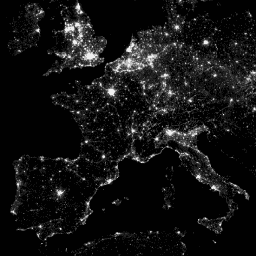
DMSP OLS: Global Radiance-Calibrated Nighttime Lights Version 4, Defense Meteorological Program Operational Linescan System](/earth-engine/datasets/catalog/NOAA_DMSP-OLS_CALIBRATED_LIGHTS_V4) |\n | The Defense Meteorological Program (DMSP) Operational Line-Scan System (OLS) has a unique capability to detect visible and near-infrared (VNIR) emission sources at night. This collection contains global nighttime lights images with no sensor saturation. The sensor is typically operated at a high-gain setting to enable ... |\n | [dmsp](/earth-engine/datasets/tags/dmsp) [eog](/earth-engine/datasets/tags/eog) [imagery](/earth-engine/datasets/tags/imagery) [lights](/earth-engine/datasets/tags/lights) [nighttime](/earth-engine/datasets/tags/nighttime) [ols](/earth-engine/datasets/tags/ols) |\n\n-\n\n |------------------------------------------------------------------------------------------------------------------------------------------------------------------------------------------------------------------------------------------------------------------------------------------------------------------------------------------|\n | [### DMSP OLS: Nighttime Lights Time Series Version 4, Defense Meteorological Program Operational Linescan System](/earth-engine/datasets/catalog/NOAA_DMSP-OLS_NIGHTTIME_LIGHTS) |\n | The Defense Meteorological Program (DMSP) Operational Line-Scan System (OLS) has a unique capability to detect visible and near-infrared (VNIR) emission sources at night. Version 4 of the DMSP-OLS Nighttime Lights Time Series consists of cloud-free composites made using all the available archived DMSP-OLS smooth resolution ... |\n | [dmsp](/earth-engine/datasets/tags/dmsp) [eog](/earth-engine/datasets/tags/eog) [imagery](/earth-engine/datasets/tags/imagery) [lights](/earth-engine/datasets/tags/lights) [nighttime](/earth-engine/datasets/tags/nighttime) [ols](/earth-engine/datasets/tags/ols) |\n\n-\n\n |---------------------------------------------------------------------------------------------------------------------------------------------------------------------------------------------------------------------------------------------------------------------------------------------------------------------|\n | [### NAIP: National Agriculture Imagery Program](/earth-engine/datasets/catalog/USDA_NAIP_DOQQ) |\n | The National Agriculture Imagery Program (NAIP) acquires aerial imagery during the agricultural growing seasons in the continental U.S. NAIP projects are contracted each year based upon available funding and the imagery acquisition cycle. Beginning in 2003, NAIP was acquired on a 5-year cycle. 2008 was ... |\n | [agriculture](/earth-engine/datasets/tags/agriculture) [highres](/earth-engine/datasets/tags/highres) [imagery](/earth-engine/datasets/tags/imagery) [orthophotos](/earth-engine/datasets/tags/orthophotos) [usda](/earth-engine/datasets/tags/usda) |"]]