本文档介绍了如何查找规划路线沿途的酒店、餐厅或加油站。您将学习如何使用 Routes API 获取路线多段线,并将其与 Places API Search Along Route (SAR) 请求搭配使用。您还将了解如何通过设置沿路线的搜索起点(例如,在旅程开始 2 小时后)来获得最佳结果。
Routes API
为了搜索沿途地点,我们将使用 Routes API。来自 Routes API 响应的路线数据是一系列从起点到目的地的 LatLng 坐标。路线数据包含沿道路网行进的路线段和路线步数。
路线也会以编码的折线的形式返回,您可以将其作为输入参数传递给 SAR 请求。多段线编码是一种有损压缩算法,可让您将一系列坐标存储为单个字符串。从 Routes API 获取折线不是强制性的。您可以自行创建数据,但就本示例而言,Routes API 是获取所需数据的快速可靠的方法。
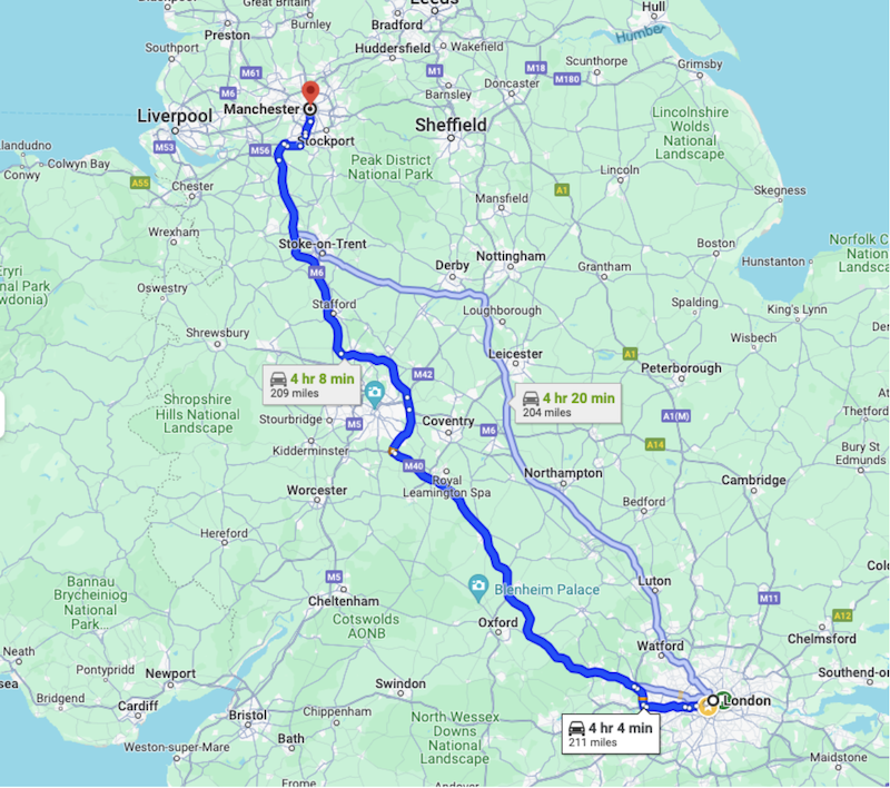
在本教程中,我们将使用从伦敦 (-37.8167,144.9619) 到曼彻斯特 (-37.8155, 144.9663) 的路线

示例中的路线:伦敦到曼彻斯特
第 1 步:从 Routes API 获取路线
如需通过 Routes API 获取路线,您需要提供以下信息:
- 出发地和目的地
- 交通方式(驾车、步行等)
- 任何途经点(可选)
- 任何偏好设置(避开收费站、避开高速公路等)
- 流量感知路由偏好设置可提供最精确的估计值,但计算量较大,因此会增加响应的延迟时间。
{"origin":{
    "location": {
        "latLng":{
            "latitude":  -37.8167,
            "longitude": 144.9619
        }
    }
},
"destination":{
    "location": {
        "latLng":{
            "latitude":-37.8155,
            "longitude": 144.9663
        }
    }
},
"routingPreference":"TRAFFIC_AWARE",
"travelMode":"DRIVE"
}
在进行调用时,请务必在标头字段掩码中添加“encodedPolyline”字段。
headers = {
    "Content-Type": "application/json",
    "X-Goog-FieldMask": "routes.distanceMeters,routes.duration,routes.legs,routes.polyline.encodedPolyline"
}
在请求中提供此信息后,Routes API 将返回一个路线对象。路线对象将包含以下信息:
- 路线的总距离
- 路线的总时长
- 路线的各个路段和步骤
- 路线、路段和步行的编码多段线。
{
  "routes": [
    {
      "legs": [
        {
          "distanceMeters": 321799,
          "duration": "15401s",
          "staticDuration": "14518s",
          "polyline": {
            "encodedPolyline": "y_kyH`_XOr@q@xKGnBBZ|AlGPj@Y^k@^MEqAfAQLK?eI … <rest of content removed for readability>"
          },
          "startLocation": {
            "latLng": {
              "latitude": 51.507334500000006,
              "longitude": -0.1280107
            }
          },
          "endLocation": {
            "latLng": {
              "latitude": 53.4808513,
              "longitude": -2.2425864
            }
          },
          "steps": [
            {
              "distanceMeters": 320,
              "staticDuration": "82s",
              "polyline": {
                "encodedPolyline": "y_kyH`_XOr@q@xKGnBBZ|AlG"
              },
              "startLocation": {
                "latLng": {
                  "latitude": 51.507334500000006,
                  "longitude": -0.1280107
                }
              },
              "endLocation": {
                "latLng": {
                  "latitude": 51.507207,
                  "longitude": -0.1323681
                }
              },
              "navigationInstruction": {
                "maneuver": "DEPART",
                "instructions": "Head northwest on Trafalgar Sq/A4 toward Spring Gardens\nContinue to follow A4\nLeaving toll zone\nEntering toll zone\nLeaving toll zone in 210m at Haymarket"
              },
              "localizedValues": {
                "distance": {
                  "text": "0.3 km"
                },
                "staticDuration": {
                  "text": "1 min"
                }
              },
# rest of the response removed for readability
第 2 步:沿途搜索请求
Places API 文本搜索具有“沿路线搜索”请求,可让您搜索路线沿途的地点。如需发出“沿路线搜索”请求,您至少需要提供以下信息:
- 响应中返回的字段的字段掩码
- 在 Google Cloud 控制台中启用的 API 的有效 API 密钥
- 搜索文本字符串,用于说明您要查找的地点,例如“辣味素食餐厅”
- 从之前的 Routes API 调用中检索到的路线的编码多段线
- Places Text Search API 端点的网址
import requests

url = 'https://places.googleapis.com/v1/places:searchText'
api_key = 'YOUR_API_KEY'  # Replace with your actual API key
route_polyline = 'YOUR_ROUTE_POLYLINE'  # Replace with your encoded route polyline

headers = {
    'Content-Type': 'application/json',
    'X-Goog-Api-Key': api_key,
    'X-Goog-FieldMask': 'places.displayName,places.formattedAddress,places.priceLevel'
}

data = {
    "textQuery":
 "Spicy Vegetarian Food",
    "searchAlongRouteParameters": {
        "polyline": {
            "encodedPolyline": route_polyline
        }
    }
}

response = requests.post(url, headers=headers, json=data)
示例请求数据
“沿途搜索”请求将返回位于路线沿途的地点列表。以下是示例数据的一小部分。您可以通过设置结果数量上限参数来限制响应的长度,当然,添加更多字段会增加收到的数据量。如需详细了解 Places API 响应,请参阅文档。
{
  "places": [
    {
      "formattedAddress": "33 Haymarket, London SW1Y 4HA, UK",
      "displayName": {
        "text": "xxx",
        "languageCode": "en"
      }
    },
    {
      "formattedAddress": "224 Piccadilly, London W1J 9HP, UK",
      "priceLevel": "PRICE_LEVEL_MODERATE",
      "displayName": {
        "text": "yyy",
        "languageCode": "en"
      }
    },
    {
      "formattedAddress": "63 Neal St, London WC2H 9PJ, UK",
      "displayName": {
        "text": "zzz",
        "languageCode": "en"
      }
    },
响应数据示例
路线摘要和绕行时间
仅查找位置信息固然不错,但如果能添加前往这些位置所需的时间信息,就更实用了。Places API 文本搜索中的 SAR 还可以返回一个包含出行时长和距离的路线摘要字段。“路线摘要”数据字段是响应根的子级,因此您不得在字段掩码中包含“places.”前缀。
'X-Goog-FieldMask': 'places.displayName,places.formattedAddress,places.priceLevel,routingSummaries'
为了获取摘要,您还必须提供用于计算的搜索来源位置参数。
"routingParameters": {
      "origin": {
        "latitude":  -37.8167,
        "longitude": 144.9619
      }
    }
收到响应后,您会看到一个包含路线摘要的新部分,其中包含具有时长和距离(以米为单位)的路段。
"routingSummaries": [
    {
      "legs": [
        {
          "duration": "662s",
          "distanceMeters": 3093
        }
      ]
    },
接下来,我们来看看如何定义沿路线开始搜索的位置。
第 3 步:获取路线沿途 2 小时后的位置
假设一个正常的使用情形,即司机想在路线中途而非起点寻找餐厅。在我们的示例中,从伦敦到曼彻斯特的行程大约需要 4 小时。司机想在路线沿途 2 小时车程处寻找一家餐厅。此请求会使我们获得 120 分钟 * 60 秒 = 7200 秒的时长。
在 Routes API 响应中,我们提供了路线中每个路段和路段中每个步行的时长。请务必在请求的字段掩码中添加“legs”字段。循环遍历各个腿和步,直到累积时长达到 2 小时或 7200 秒的限制。然后,我们找到了要设置为 SAR 请求起点的腿和步数
为了加快工作速度,您不妨试用 Python 的折线库。您可以使用它从“polyline.endodedPolyline”数据字段中获取坐标。
在环境终端中运行以下命令。
> pip install polyline
import requests
import polyline

# We've covered getting a Routes API response earlier,
data = response.json()

  # Extract the first route and its encoded polyline
  route = data["routes"][0]
  polyline_points = polyline.decode(route["polyline"]["encodedPolyline"])

  # Calculate total duration of the route in seconds
  total_duration_seconds = route["duration"]

  # Calculate the desired time offset in seconds, 2h = 120 minutes * 60
  desired_time_offset_seconds = time_offset_minutes * 60

  # Iterate through the legs and steps to find the point at the desired time offset
  elapsed_time_seconds = 0
  for leg in route["legs"]:
      for step in leg["steps"]:
          step_duration_seconds = step["staticDuration"]

          # Check if the desired time offset falls within this step, remove last "s" from string and convert to int
          second_value = int(step_duration_seconds[:-1])
          if elapsed_time_seconds + second_value >= desired_time_offset_seconds:
              # Interpolate to find the exact point within the step
              fraction_of_step = (desired_time_offset_seconds - elapsed_time_seconds) / second_value
              step_polyline_points = polyline.decode(step["polyline"]["encodedPolyline"])
              index = int(len(step_polyline_points) * fraction_of_step)
              return step_polyline_points[index]

          elapsed_time_seconds += second_value

  # If the point is not found (e.g., time offset exceeds route duration)
  return None
现在,我们已经找到了路线中位于旅程开始 2 小时后的位置,接下来可以在请求中使用该位置。只需在“origin”参数中添加纬度和经度即可,而“origin”参数本身是“routingParameters”参数的一部分。 建议使用我们之前介绍的“routingSummaries”数据字段。 您还可以添加其他参数,例如出行方式和避开收费站的说明(如果您想这样做)。
"routingParameters": {
    "origin": {
      "latitude": xx.xxxx,
      "longitude": yy.yyyy
    },
    "travelMode":"DRIVE",
    "routeModifiers": {
      "avoidTolls": true
    }
  }

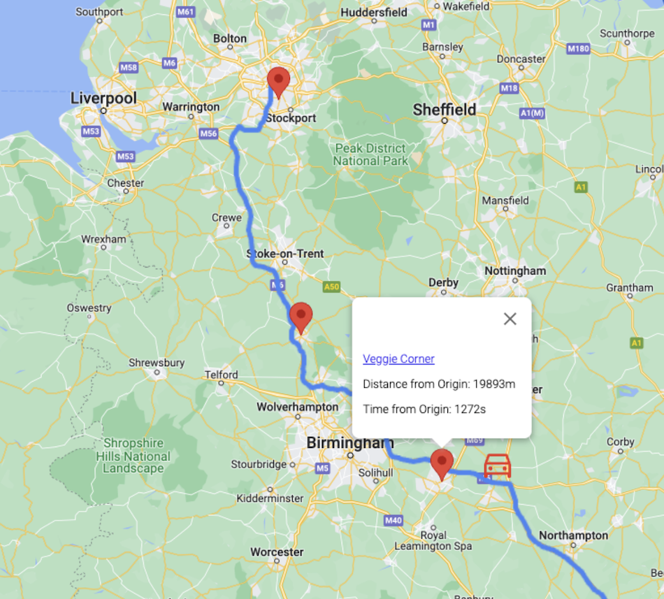
示例结果(添加了汽车图标以显示搜索来源)。
如图所示,API 返回的地点偏向于路线的终点,结果从旅程的大约中途开始。搜索功能仍由相同的 Google Maps Platform 数据提供支持,这些数据会考虑地点相关性和距离等因素。
总结
在本教程中,我们学习了如何将两个 Google Maps Platform API(路线和地点)结合使用,以规划行程并在旅程开始 2 小时后查找用餐地点。需要采取的步骤包括:获取包含路线中每个路段的纬度和经度坐标的编码折线,以及设置“沿途搜索”请求来源以获得最佳结果。
此功能为 Places API 中已有的文本搜索和附近搜索功能添加了一款强大的新工具。接下来,我们可能会添加位置信息服务,以便您可以使用司机位置作为起点来寻找最佳搜索起点。此外,此功能还可与车载语音助理完美搭配使用,您只需说出自己喜欢的餐饮选项即可。
后续操作
- 试用文档中的示例。
- 提供反馈。
建议的延伸阅读材料:
参稿人
Google 负责维护本文档。以下贡献者最初撰写了此内容。
主要作者:Mikko Toivanen | Google Maps Platform 解决方案工程师
