การวางซ้อนพื้น
จัดทุกอย่างให้เป็นระเบียบอยู่เสมอด้วยคอลเล็กชัน
บันทึกและจัดหมวดหมู่เนื้อหาตามค่ากำหนดของคุณ
การวางซ้อนบนพื้นคือการวางซ้อนบนแผนที่ที่เชื่อมโยงกับพิกัดละติจูด/ลองจิจูด
จึงจะเลื่อนเมื่อคุณลากหรือซูมแผนที่

บทนำ
การวางซ้อนพื้นคือรูปภาพที่ตรึงไว้กับแผนที่ การวางซ้อนพื้นดินจะวางแนวกับพื้นผิวโลก
แทนที่จะเป็นหน้าจอ ดังนั้นการหมุน เอียง หรือซูมแผนที่จะเปลี่ยน
การวางแนวของรูปภาพ ซึ่งแตกต่างจากเครื่องหมาย
หากต้องการเพิ่มภาพซ้อนทับพื้น ให้สร้างออบเจ็กต์
GMSGroundOverlay
ที่กำหนดทั้งไอคอนและขอบเขต หากไม่ระบุทั้ง 2 อย่างนี้
จะทำให้ภาพซ้อนทับภาคพื้นดินไม่ปรากฏบนแผนที่ คุณสามารถระบุ
การตั้งค่าเพิ่มเติมที่จะส่งผลต่อการวางตำแหน่งรูปภาพบนแผนที่ได้
เมื่อกำหนดตัวเลือกที่จำเป็นแล้ว ให้ตั้งค่าพร็อพเพอร์ตี้ map
ของออบเจ็กต์นี้เพื่อ
เพิ่มการวางซ้อน
การเพิ่มการวางซ้อน
- สร้างออบเจ็กต์
GMSGroundOverlay
ใหม่
- ตั้งค่าพร็อพเพอร์ตี้
icon
เป็นอินสแตนซ์ของ UIImage
- ตั้งค่าพร็อพเพอร์ตี้
bounds
เป็นอินสแตนซ์ของ GMSCoordinateBounds
ขอบเขตแสดงถึงมุมตะวันตกเฉียงใต้และตะวันออกเฉียงเหนือของรูปภาพ
- ตั้งค่าพร็อพเพอร์ตี้ที่ไม่บังคับ เช่น
bearing
และ zoomLevel
ตามต้องการ
- ตั้งค่าพร็อพเพอร์ตี้
map
รูปภาพจะปรากฏบนแผนที่
ตัวอย่างด้านล่างแสดงวิธีเพิ่ม Ground Overlay ลงในออบเจ็กต์ GMSMapView
ที่มีอยู่
Swift
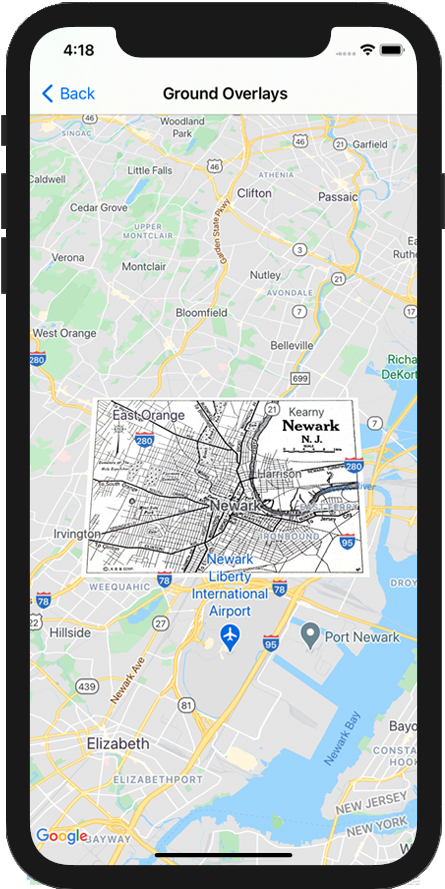
let southWest = CLLocationCoordinate2D(latitude: 40.712216, longitude: -74.22655)
let northEast = CLLocationCoordinate2D(latitude: 40.773941, longitude: -74.12544)
let overlayBounds = GMSCoordinateBounds(coordinate: southWest, coordinate: northEast)
// Image from http://www.lib.utexas.edu/maps/historical/newark_nj_1922.jpg
let icon = UIImage(named: "newark_nj_1922")
let overlay = GMSGroundOverlay(bounds: overlayBounds, icon: icon)
overlay.bearing = 0
overlay.map = mapView
Objective-C
CLLocationCoordinate2D southWest = CLLocationCoordinate2DMake(40.712216,-74.22655);
CLLocationCoordinate2D northEast = CLLocationCoordinate2DMake(40.773941,-74.12544);
GMSCoordinateBounds *overlayBounds = [[GMSCoordinateBounds alloc] initWithCoordinate:southWest
coordinate:northEast];
// Image from http://www.lib.utexas.edu/maps/historical/newark_nj_1922.jpg
UIImage *icon = [UIImage imageNamed:@"newark_nj_1922"];
GMSGroundOverlay *overlay = [GMSGroundOverlay groundOverlayWithBounds:overlayBounds icon:icon];
overlay.bearing = 0;
overlay.map = mapView;
การนำภาพซ้อนทับออก
คุณนำภาพซ้อนทับภาคพื้นดินออกจากแผนที่ได้โดยตั้งค่าพร็อพเพอร์ตี้ GMSGroundOverlay
ของ map
เป็น nil
หรือจะนำภาพซ้อนทับทั้งหมด
ออก (รวมถึงภาพซ้อนทับบนพื้นซึ่งปัจจุบันอยู่ในแผนที่) โดยเรียกใช้เมธอด
GMSMapView
clear
ก็ได้
Objective-C
[mapView clear];
หากต้องการแก้ไขภาพซ้อนทับพื้นหลังจากที่เพิ่มลงในแผนที่แล้ว โปรดเก็บออบเจ็กต์ GMSGroundOverlay
ไว้ คุณ
แก้ไขภาพซ้อนทับพื้นได้ในภายหลังโดยทำการเปลี่ยนแปลงออบเจ็กต์นี้
Swift
let overlay = GMSGroundOverlay(bounds: overlayBounds, icon: icon)
overlay.bearing = 0
overlay.map = mapView
// ...
overlay.isTappable = true
Objective-C
GMSGroundOverlay *overlay = [GMSGroundOverlay groundOverlayWithBounds:overlayBounds icon:icon];
overlay.bearing = 0;
overlay.map = mapView;
// ...
overlay.tappable = YES;
กิจกรรม
คุณสามารถฟังเหตุการณ์ที่เกิดขึ้นบนแผนที่ เช่น เมื่อผู้ใช้แตะ
ภาพซ้อน หากต้องการฟังเหตุการณ์ คุณต้องใช้โปรโตคอล GMSMapViewDelegate
ดูคำแนะนำเกี่ยวกับเหตุการณ์และรายการเมธอดใน
GMSMapViewDelegate
เนื้อหาของหน้าเว็บนี้ได้รับอนุญาตภายใต้ใบอนุญาตที่ต้องระบุที่มาของครีเอทีฟคอมมอนส์ 4.0 และตัวอย่างโค้ดได้รับอนุญาตภายใต้ใบอนุญาต Apache 2.0 เว้นแต่จะระบุไว้เป็นอย่างอื่น โปรดดูรายละเอียดที่นโยบายเว็บไซต์ Google Developers Java เป็นเครื่องหมายการค้าจดทะเบียนของ Oracle และ/หรือบริษัทในเครือ
อัปเดตล่าสุด 2025-08-31 UTC
[null,null,["อัปเดตล่าสุด 2025-08-31 UTC"],[[["\u003cp\u003eGround overlays are images fixed to a map, oriented to the Earth's surface, and change orientation with map interactions.\u003c/p\u003e\n"],["\u003cp\u003eTo add a ground overlay, create a \u003ccode\u003eGMSGroundOverlay\u003c/code\u003e object, define its icon, bounds, and optional settings, then set its \u003ccode\u003emap\u003c/code\u003e property.\u003c/p\u003e\n"],["\u003cp\u003eGround overlays can be removed by setting the \u003ccode\u003emap\u003c/code\u003e property to \u003ccode\u003enil\u003c/code\u003e or using the \u003ccode\u003eclear\u003c/code\u003e method on the \u003ccode\u003eGMSMapView\u003c/code\u003e.\u003c/p\u003e\n"],["\u003cp\u003eModifications to existing ground overlays can be made by accessing and updating the \u003ccode\u003eGMSGroundOverlay\u003c/code\u003e object directly.\u003c/p\u003e\n"],["\u003cp\u003eImplement the \u003ccode\u003eGMSMapViewDelegate\u003c/code\u003e protocol to listen to events like user taps on the overlay.\u003c/p\u003e\n"]]],["Ground overlays, images fixed to a map using latitude/longitude, are added by creating a `GMSGroundOverlay` object. This requires setting both the `icon` (an image) and `bounds` (southwest/northeast coordinates). Optionally, set properties like `bearing` and `zoomLevel`. To display, assign the object's `map` property. Overlays are removed by setting `map` to `nil` or using the `clear` method. Modifications require retaining the `GMSGroundOverlay` object and to listen for events, you must implement `GMSMapViewDelegate`.\n"],null,["Select platform: [Android](/maps/documentation/android-sdk/groundoverlay \"View this page for the Android platform docs.\") [iOS](/maps/documentation/ios-sdk/overlays \"View this page for the iOS platform docs.\") [JavaScript](/maps/documentation/javascript/groundoverlays \"View this page for the JavaScript platform docs.\")\n\n\u003cbr /\u003e\n\nGround overlays are overlays on the map that are tied to latitude/longitude\ncoordinates, so they move when you drag or zoom the map.\n\nIntroduction\n\nA ground overlay is an image that is fixed to a map. Unlike\n[markers](/maps/documentation/ios-sdk/marker), ground overlays are oriented against the Earth's surface\nrather than the screen, so rotating, tilting or zooming the map will change\nthe orientation of the image.\n\nTo add a ground overlay, create a\n[`GMSGroundOverlay`](/maps/documentation/ios-sdk/reference/objc/Classes/GMSGroundOverlay)\nobject that defines both an icon and a bounds. Failing to specify either will\ncause the ground overlay to not appear on the map. You can optionally specify\nadditional settings that will affect the positioning of the image on the map.\nOnce you've defined the necessary options, set this object's `map` property to\nadd the overlay.\n\nAdding an overlay\n\n1. Instantiate a new `GMSGroundOverlay` object\n2. Set the `icon` property to an instance of `UIImage`.\n3. Set the `bounds` property to an instance of `GMSCoordinateBounds`. The bounds represent the south west, and north east corners of the image.\n4. Set optional properties, such as `bearing` and `zoomLevel`, as desired.\n5. Set the `map` property - the image appears on the map.\n\nThe below example demonstrates how to add a ground overlay to an existing\n`GMSMapView` object.\n\n\nSwift \n\n```swift\nlet southWest = CLLocationCoordinate2D(latitude: 40.712216, longitude: -74.22655)\nlet northEast = CLLocationCoordinate2D(latitude: 40.773941, longitude: -74.12544)\nlet overlayBounds = GMSCoordinateBounds(coordinate: southWest, coordinate: northEast)\n\n// Image from http://www.lib.utexas.edu/maps/historical/newark_nj_1922.jpg\nlet icon = UIImage(named: \"newark_nj_1922\")\n\nlet overlay = GMSGroundOverlay(bounds: overlayBounds, icon: icon)\noverlay.bearing = 0\noverlay.map = mapView\n \n```\n\nObjective-C \n\n```objective-c\nCLLocationCoordinate2D southWest = CLLocationCoordinate2DMake(40.712216,-74.22655);\nCLLocationCoordinate2D northEast = CLLocationCoordinate2DMake(40.773941,-74.12544);\nGMSCoordinateBounds *overlayBounds = [[GMSCoordinateBounds alloc] initWithCoordinate:southWest\n coordinate:northEast];\n\n// Image from http://www.lib.utexas.edu/maps/historical/newark_nj_1922.jpg\nUIImage *icon = [UIImage imageNamed:@\"newark_nj_1922\"];\nGMSGroundOverlay *overlay = [GMSGroundOverlay groundOverlayWithBounds:overlayBounds icon:icon];\noverlay.bearing = 0;\noverlay.map = mapView;\n \n```\n\n\u003cbr /\u003e\n\nRemoving an overlay\n\nYou can remove a ground overlay from the map by setting your\n`GMSGroundOverlay`'s `map` property to `nil`. Alternately, you can remove all\nof the overlays (including ground overlays currently on the map by calling the\n`GMSMapView` `clear` method.\n\n\nSwift \n\n```swift\nmapView.clear()\n \n```\n\nObjective-C \n\n```objective-c\n[mapView clear];\n \n```\n\n\u003cbr /\u003e\n\nIf you wish to make modifications to a ground overlay after you've added it to\nthe map, ensure that you keep hold of the `GMSGroundOverlay` object. You can\nmodify the ground overlay later by making changes to this object.\n\n\nSwift \n\n```swift\nlet overlay = GMSGroundOverlay(bounds: overlayBounds, icon: icon)\noverlay.bearing = 0\noverlay.map = mapView\n\n// ...\n\noverlay.isTappable = true\n \n```\n\nObjective-C \n\n```objective-c\nGMSGroundOverlay *overlay = [GMSGroundOverlay groundOverlayWithBounds:overlayBounds icon:icon];\noverlay.bearing = 0;\noverlay.map = mapView;\n\n// ...\noverlay.tappable = YES;\n \n```\n\n\u003cbr /\u003e\n\nEvents\n\nYou can listen to events that occur on the map, such as when a user taps an\noverlay. To listen to events, you must implement the\n[`GMSMapViewDelegate`](/maps/documentation/ios-sdk/reference/objc/Protocols/GMSMapViewDelegate) protocol. See the\n[guide to events](/maps/documentation/ios-sdk/events) and the list of methods on the\n[`GMSMapViewDelegate`](/maps/documentation/ios-sdk/reference/objc/Protocols/GMSMapViewDelegate)."]]