踏出第一步
透過集合功能整理內容
你可以依據偏好儲存及分類內容。
請按照下列步驟設定資料集資料導向樣式。
取得 API 金鑰並啟用 API
如要使用資料集資料導向樣式,您需要:
已連結帳單帳戶的 Google Cloud 專案,並啟用 Maps JavaScript API 和 Maps Datasets API。
詳情請參閱「設定 Google Cloud 專案」一文。
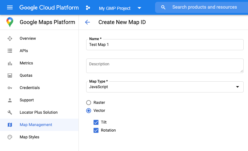
取得 API 金鑰
啟用 Maps JavaScript API
啟用 Maps Datasets API
建立地圖 ID
如要建立新的地圖 ID,請參考關於雲端自訂功能的說明。請將「地圖類型」設為「JavaScript」,然後選取「向量」選項。
將地圖例項化時,請使用 mapId
屬性提供地圖 ID。
地圖 ID 對應的地圖樣式必須與要顯示的資料集相關聯。
const position = new google.maps.LatLng(40.75, -74.05);
const map = new google.maps.Map(document.getElementById('map'), {
zoom: 11,
center: position,
mapId: 'YOUR_MAP_ID',
});

建立新地圖樣式
如要建立新地圖樣式,請按照「建立及使用地圖樣式」一文中的說明操作,並將樣式與剛建立的地圖 ID 建立關聯。
更新地圖初始化程式碼
如要使用資料集資料導向樣式,請先在應用程式程式碼中加入內嵌 Bootstrap 載入器來載入 Maps JavaScript API,如下所示 (在 API script
代碼中使用 v=beta
):
<script>
(g=>{var h,a,k,p="The Google Maps JavaScript API",c="google",l="importLibrary",q="__ib__",m=document,b=window;b=b[c]||(b[c]={});var d=b.maps||(b.maps={}),r=new Set,e=new URLSearchParams,u=()=>h||(h=new Promise(async(f,n)=>{await (a=m.createElement("script"));e.set("libraries",[...r]+"");for(k in g)e.set(k.replace(/[A-Z]/g,t=>"_"+t[0].toLowerCase()),g[k]);e.set("callback",c+".maps."+q);a.src=`https://maps.${c}apis.com/maps/api/js?`+e;d[q]=f;a.onerror=()=>h=n(Error(p+" could not load."));a.nonce=m.querySelector("script[nonce]")?.nonce||"";m.head.append(a)}));d[l]?console.warn(p+" only loads once. Ignoring:",g):d[l]=(f,...n)=>r.add(f)&&u().then(()=>d[l](f,...n))})({
key: "YOUR_API_KEY",
v: "weekly",
// Use the 'v' parameter to indicate the version to use (weekly, beta, alpha, etc.).
// Add other bootstrap parameters as needed, using camel case.
});
</script>
檢查地圖功能 (選用)
如要使用資料集資料導向樣式,需要有地圖 ID。如果缺少地圖 ID 或傳遞無效的地圖 ID,就無法載入資料地圖項目。如要解決這個問題,您可以加入 mapcapabilities_changed
事件監聽器,訂閱地圖功能變更。這樣一來便可檢查是否符合下列條件:
- 使用有效的地圖 ID。
- 地圖 ID 與向量地圖相關聯。
您不一定要使用「地圖功能」。我們建議只在測試、進行疑難排解或執行階段回退時才使用。
// Optional: subscribe to map capability changes.
map.addListener('mapcapabilities_changed', () => {
const mapCapabilities = map.getMapCapabilities();
if (!mapCapabilities.isDataDrivenStylingAvailable) {
// Data-driven styling is *not* available, add a fallback.
// Existing feature layers are also unavailable.
}
});
後續步驟
除非另有註明,否則本頁面中的內容是採用創用 CC 姓名標示 4.0 授權,程式碼範例則為阿帕契 2.0 授權。詳情請參閱《Google Developers 網站政策》。Java 是 Oracle 和/或其關聯企業的註冊商標。
上次更新時間:2025-08-31 (世界標準時間)。
[null,null,["上次更新時間:2025-08-31 (世界標準時間)。"],[[["\u003cp\u003eTo utilize data-driven styling for datasets, obtain an API key, enable necessary APIs (Maps JavaScript API and Maps Datasets API), and create a map ID associated with a vector-based map style.\u003c/p\u003e\n"],["\u003cp\u003eInitialization involves providing the map ID during map instantiation and loading the Maps JavaScript API with the \u003ccode\u003ev=beta\u003c/code\u003e parameter in the script tag.\u003c/p\u003e\n"],["\u003cp\u003eFor troubleshooting, optionally use the \u003ccode\u003emapcapabilities_changed\u003c/code\u003e listener to verify map capabilities, such as a valid map ID linked to a vector map, ensuring data-driven styling functionality.\u003c/p\u003e\n"],["\u003cp\u003eAfter setup, proceed to create and upload a dataset to leverage data-driven styling within your maps.\u003c/p\u003e\n"]]],["To utilize data-driven styling, first get an API key and enable the Maps JavaScript and Datasets APIs. Create a map ID of type \"JavaScript\" and \"Vector,\" then associate it with a new map style. In the map initialization code, use the `mapId` property with your created ID and load the Maps JavaScript API with an inline bootstrap loader. Optionally, use a `mapcapabilities_changed` listener to ensure a valid map ID is used and troubleshoot any issues.\n"],null,["Select platform: [Android](/maps/documentation/android-sdk/dds-datasets/start \"View this page for the Android platform docs.\") [iOS](/maps/documentation/ios-sdk/dds-datasets/start \"View this page for the iOS platform docs.\") [JavaScript](/maps/documentation/javascript/dds-datasets/start \"View this page for the JavaScript platform docs.\")\n\n\u003cbr /\u003e\n\nFollow these steps to get set up with the data-driven styling for datasets.\n\nGet an API key and enable APIs\n\nBefore using the data-driven styling for datasets, you need:\nGoogle Cloud project with a billing account, and both the\nMaps JavaScript API and the Maps Datasets API enabled.\nTo learn more, see\n[Set up your Google Cloud project](/maps/documentation/javascript/cloud-setup).\n\n[Get an API key](/maps/documentation/javascript/get-api-key)\n\n\n[Enable the Maps JavaScript API](https://console.cloud.google.com/apis/library/maps-backend.googleapis.com)\n\n\n[Enable the Maps Datasets API](https://console.cloud.google.com/apis/library/mapsplatformdatasets.googleapis.com)\n\nCreate a map ID\n\nTo create a new [map ID](/maps/documentation/javascript/map-ids/mapid-over),\nfollow the steps in\n[Cloud customization](/maps/documentation/javascript/map-ids/get-map-id).\nSet the Map type to **JavaScript** , and select the **Vector** option.\n\nProvide a map ID using the `mapId` property when you instantiate the map .\nThe map ID must correspond to the map style that is associated with the dataset\nto display. \n\n```javascript\nconst position = new google.maps.LatLng(40.75, -74.05);\nconst map = new google.maps.Map(document.getElementById('map'), {\n zoom: 11,\n center: position,\n mapId: 'YOUR_MAP_ID',\n});\n```\n\nCreate a new map style\n\nTo create a new map style, follow the instructions in\n[Create and use map styles](/maps/documentation/javascript/cloud-customization/map-styles-leg)\nto create the style, and\n[associate the style with the map ID you just created](/maps/documentation/javascript/cloud-customization/map-styles-leg#associate-style-with-map-id).\n\nUpdate your map initialization code\n\nTo use the data-driven styling for datasets, first load the\nMaps JavaScript API, by adding the inline bootstrap loader to\nyour application code, as shown here\n(use `v=beta` in your API `script` tag): \n\n```javascript\n\u003cscript\u003e\n (g=\u003e{var h,a,k,p=\"The Google Maps JavaScript API\",c=\"google\",l=\"importLibrary\",q=\"__ib__\",m=document,b=window;b=b[c]||(b[c]={});var d=b.maps||(b.maps={}),r=new Set,e=new URLSearchParams,u=()=\u003eh||(h=new Promise(async(f,n)=\u003e{await (a=m.createElement(\"script\"));e.set(\"libraries\",[...r]+\"\");for(k in g)e.set(k.replace(/[A-Z]/g,t=\u003e\"_\"+t[0].toLowerCase()),g[k]);e.set(\"callback\",c+\".maps.\"+q);a.src=`https://maps.${c}apis.com/maps/api/js?`+e;d[q]=f;a.onerror=()=\u003eh=n(Error(p+\" could not load.\"));a.nonce=m.querySelector(\"script[nonce]\")?.nonce||\"\";m.head.append(a)}));d[l]?console.warn(p+\" only loads once. Ignoring:\",g):d[l]=(f,...n)=\u003er.add(f)&&u().then(()=\u003ed[l](f,...n))})({\n key: \"YOUR_API_KEY\",\n v: \"weekly\",\n // Use the 'v' parameter to indicate the /maps/documentation/javascript/versions to use (weekly, beta, alpha, etc.).\n // Add other /maps/documentation/javascript/load-maps-js-api#required_parameters as needed, using camel case.\n });\n\u003c/script\u003e\n```\n\nCheck map capabilities (optional)\n\nData-driven styling for datasets requires a map ID. If the map ID is missing,\nor an invalid map ID is passed, data features cannot load. As a\ntroubleshooting step, you can add a `mapcapabilities_changed` listener to\nsubscribe to map capability changes. This will indicate whether the following\nconditions have been met:\n\n- A valid map ID is in use.\n- The map ID is associated with a vector map.\n\nUsing Map Capabilities is optional, and recommended only for testing and\ntroubleshooting purposes, or for runtime fallback purposes. \n\n```javascript\n// Optional: subscribe to map capability changes.\nmap.addListener('mapcapabilities_changed', () =\u003e {\n const mapCapabilities = map.getMapCapabilities();\n\n if (!mapCapabilities.isDataDrivenStylingAvailable) {\n // Data-driven styling is *not* available, add a fallback.\n // Existing feature layers are also unavailable.\n }\n});\n```\n\nNext steps\n\n- [Create and upload a dataset](/maps/documentation/javascript/dds-datasets/create-dataset)"]]