시작하기
컬렉션을 사용해 정리하기
내 환경설정을 기준으로 콘텐츠를 저장하고 분류하세요.
데이터 세트를 위한 데이터 기반 스타일 지정으로 설정하려면 다음 단계를 따르세요.
API 키 가져오기 및 API 사용 설정
데이터 세트를 위해 데이터 기반 스타일 지정을 사용하려면 결제 계정이 있는 Google Cloud 프로젝트가 있어야 하고 Maps JavaScript API와 Maps Datasets API가 모두 사용 설정되어 있어야 합니다.
자세한 내용은 Google Cloud 프로젝트 설정을 참고하세요.
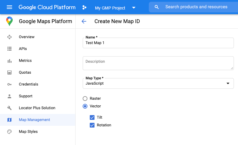
API 키 가져오기
Maps JavaScript API 사용 설정
Maps Datasets API 사용 설정
지도 ID 만들기
새 지도 ID를 만들려면 클라우드 맞춤설정의 단계를 따르세요.
지도 유형을 JavaScript로 설정하고 벡터 옵션을 선택합니다.
지도를 인스턴스화할 때 mapId
속성을 사용하여 지도 ID를 제공합니다.
지도 ID는 표시할 데이터 세트와 연결된 지도 스타일과 일치해야 합니다.
const position = new google.maps.LatLng(40.75, -74.05);
const map = new google.maps.Map(document.getElementById('map'), {
zoom: 11,
center: position,
mapId: 'YOUR_MAP_ID',
});

새 지도 스타일 만들기
새 지도 스타일을 만들려면 지도 스타일 만들기 및 사용의 안내에 따라 스타일을 만들어 방금 만든 지도 ID와 연결하세요.
지도 초기화 코드 업데이트
데이터 세트를 위해 데이터 기반 스타일 지정을 사용하려면 먼저 여기에 표시된 것처럼 애플리케이션 코드에 인라인 부트스트랩 로더를 추가하여 Maps JavaScript API를 로드합니다(API script
태그에서 v=beta
사용).
<script>
(g=>{var h,a,k,p="The Google Maps JavaScript API",c="google",l="importLibrary",q="__ib__",m=document,b=window;b=b[c]||(b[c]={});var d=b.maps||(b.maps={}),r=new Set,e=new URLSearchParams,u=()=>h||(h=new Promise(async(f,n)=>{await (a=m.createElement("script"));e.set("libraries",[...r]+"");for(k in g)e.set(k.replace(/[A-Z]/g,t=>"_"+t[0].toLowerCase()),g[k]);e.set("callback",c+".maps."+q);a.src=`https://maps.${c}apis.com/maps/api/js?`+e;d[q]=f;a.onerror=()=>h=n(Error(p+" could not load."));a.nonce=m.querySelector("script[nonce]")?.nonce||"";m.head.append(a)}));d[l]?console.warn(p+" only loads once. Ignoring:",g):d[l]=(f,...n)=>r.add(f)&&u().then(()=>d[l](f,...n))})({
key: "YOUR_API_KEY",
v: "weekly",
// Use the 'v' parameter to indicate the version to use (weekly, beta, alpha, etc.).
// Add other bootstrap parameters as needed, using camel case.
});
</script>
지도 기능 확인(선택사항)
데이터 세트를 위한 데이터 기반 스타일 지정에는 지도 ID가 필요합니다. 지도 ID가 누락되었거나 잘못된 지도 ID가 전달된 경우 데이터 지형지물을 로드할 수 없습니다. 문제 해결을 위해 지도 기능 변경사항을 구독하는 mapcapabilities_changed
리스너를 추가할 수도 있습니다. 이렇게 하면 다음 조건이 충족되었는지 여부가 표시됩니다.
- 유효한 지도 ID를 사용 중인지 여부
- 지도 ID가 벡터 지도와 연결되었는지 여부
지도 기능을 사용하는 것은 선택사항이며 테스트 및 문제 해결 또는 런타임 대체 목적으로만 사용하는 것이 좋습니다.
// Optional: subscribe to map capability changes.
map.addListener('mapcapabilities_changed', () => {
const mapCapabilities = map.getMapCapabilities();
if (!mapCapabilities.isDataDrivenStylingAvailable) {
// Data-driven styling is *not* available, add a fallback.
// Existing feature layers are also unavailable.
}
});
다음 단계
달리 명시되지 않는 한 이 페이지의 콘텐츠에는 Creative Commons Attribution 4.0 라이선스에 따라 라이선스가 부여되며, 코드 샘플에는 Apache 2.0 라이선스에 따라 라이선스가 부여됩니다. 자세한 내용은 Google Developers 사이트 정책을 참조하세요. 자바는 Oracle 및/또는 Oracle 계열사의 등록 상표입니다.
최종 업데이트: 2025-08-31(UTC)
[null,null,["최종 업데이트: 2025-08-31(UTC)"],[[["\u003cp\u003eTo utilize data-driven styling for datasets, obtain an API key, enable necessary APIs (Maps JavaScript API and Maps Datasets API), and create a map ID associated with a vector-based map style.\u003c/p\u003e\n"],["\u003cp\u003eInitialization involves providing the map ID during map instantiation and loading the Maps JavaScript API with the \u003ccode\u003ev=beta\u003c/code\u003e parameter in the script tag.\u003c/p\u003e\n"],["\u003cp\u003eFor troubleshooting, optionally use the \u003ccode\u003emapcapabilities_changed\u003c/code\u003e listener to verify map capabilities, such as a valid map ID linked to a vector map, ensuring data-driven styling functionality.\u003c/p\u003e\n"],["\u003cp\u003eAfter setup, proceed to create and upload a dataset to leverage data-driven styling within your maps.\u003c/p\u003e\n"]]],["To utilize data-driven styling, first get an API key and enable the Maps JavaScript and Datasets APIs. Create a map ID of type \"JavaScript\" and \"Vector,\" then associate it with a new map style. In the map initialization code, use the `mapId` property with your created ID and load the Maps JavaScript API with an inline bootstrap loader. Optionally, use a `mapcapabilities_changed` listener to ensure a valid map ID is used and troubleshoot any issues.\n"],null,["Select platform: [Android](/maps/documentation/android-sdk/dds-datasets/start \"View this page for the Android platform docs.\") [iOS](/maps/documentation/ios-sdk/dds-datasets/start \"View this page for the iOS platform docs.\") [JavaScript](/maps/documentation/javascript/dds-datasets/start \"View this page for the JavaScript platform docs.\")\n\n\u003cbr /\u003e\n\nFollow these steps to get set up with the data-driven styling for datasets.\n\nGet an API key and enable APIs\n\nBefore using the data-driven styling for datasets, you need:\nGoogle Cloud project with a billing account, and both the\nMaps JavaScript API and the Maps Datasets API enabled.\nTo learn more, see\n[Set up your Google Cloud project](/maps/documentation/javascript/cloud-setup).\n\n[Get an API key](/maps/documentation/javascript/get-api-key)\n\n\n[Enable the Maps JavaScript API](https://console.cloud.google.com/apis/library/maps-backend.googleapis.com)\n\n\n[Enable the Maps Datasets API](https://console.cloud.google.com/apis/library/mapsplatformdatasets.googleapis.com)\n\nCreate a map ID\n\nTo create a new [map ID](/maps/documentation/javascript/map-ids/mapid-over),\nfollow the steps in\n[Cloud customization](/maps/documentation/javascript/map-ids/get-map-id).\nSet the Map type to **JavaScript** , and select the **Vector** option.\n\nProvide a map ID using the `mapId` property when you instantiate the map .\nThe map ID must correspond to the map style that is associated with the dataset\nto display. \n\n```javascript\nconst position = new google.maps.LatLng(40.75, -74.05);\nconst map = new google.maps.Map(document.getElementById('map'), {\n zoom: 11,\n center: position,\n mapId: 'YOUR_MAP_ID',\n});\n```\n\nCreate a new map style\n\nTo create a new map style, follow the instructions in\n[Create and use map styles](/maps/documentation/javascript/cloud-customization/map-styles-leg)\nto create the style, and\n[associate the style with the map ID you just created](/maps/documentation/javascript/cloud-customization/map-styles-leg#associate-style-with-map-id).\n\nUpdate your map initialization code\n\nTo use the data-driven styling for datasets, first load the\nMaps JavaScript API, by adding the inline bootstrap loader to\nyour application code, as shown here\n(use `v=beta` in your API `script` tag): \n\n```javascript\n\u003cscript\u003e\n (g=\u003e{var h,a,k,p=\"The Google Maps JavaScript API\",c=\"google\",l=\"importLibrary\",q=\"__ib__\",m=document,b=window;b=b[c]||(b[c]={});var d=b.maps||(b.maps={}),r=new Set,e=new URLSearchParams,u=()=\u003eh||(h=new Promise(async(f,n)=\u003e{await (a=m.createElement(\"script\"));e.set(\"libraries\",[...r]+\"\");for(k in g)e.set(k.replace(/[A-Z]/g,t=\u003e\"_\"+t[0].toLowerCase()),g[k]);e.set(\"callback\",c+\".maps.\"+q);a.src=`https://maps.${c}apis.com/maps/api/js?`+e;d[q]=f;a.onerror=()=\u003eh=n(Error(p+\" could not load.\"));a.nonce=m.querySelector(\"script[nonce]\")?.nonce||\"\";m.head.append(a)}));d[l]?console.warn(p+\" only loads once. Ignoring:\",g):d[l]=(f,...n)=\u003er.add(f)&&u().then(()=\u003ed[l](f,...n))})({\n key: \"YOUR_API_KEY\",\n v: \"weekly\",\n // Use the 'v' parameter to indicate the /maps/documentation/javascript/versions to use (weekly, beta, alpha, etc.).\n // Add other /maps/documentation/javascript/load-maps-js-api#required_parameters as needed, using camel case.\n });\n\u003c/script\u003e\n```\n\nCheck map capabilities (optional)\n\nData-driven styling for datasets requires a map ID. If the map ID is missing,\nor an invalid map ID is passed, data features cannot load. As a\ntroubleshooting step, you can add a `mapcapabilities_changed` listener to\nsubscribe to map capability changes. This will indicate whether the following\nconditions have been met:\n\n- A valid map ID is in use.\n- The map ID is associated with a vector map.\n\nUsing Map Capabilities is optional, and recommended only for testing and\ntroubleshooting purposes, or for runtime fallback purposes. \n\n```javascript\n// Optional: subscribe to map capability changes.\nmap.addListener('mapcapabilities_changed', () =\u003e {\n const mapCapabilities = map.getMapCapabilities();\n\n if (!mapCapabilities.isDataDrivenStylingAvailable) {\n // Data-driven styling is *not* available, add a fallback.\n // Existing feature layers are also unavailable.\n }\n});\n```\n\nNext steps\n\n- [Create and upload a dataset](/maps/documentation/javascript/dds-datasets/create-dataset)"]]