Mantieni tutto organizzato con le raccolte
Salva e classifica i contenuti in base alle tue preferenze.
Le funzionalità basate su WebGL per l'API Maps JavaScript ti consentono di
controllare l'inclinazione e la rotazione, aggiungere oggetti 3D direttamente alla mappa e altro ancora. Sono
incluse le seguenti funzionalità:
L'opzione renderingType sostituisce qualsiasi impostazione del tipo di rendering effettuata configurando un ID mappa.
Per attivare l'inclinazione e la rotazione, imposta l'opzione della mappa tiltInteractionEnabled su
true o chiama map.setTiltInteractionEnabled.
Per attivare lo spostamento della visualizzazione, imposta l'opzione della mappa headingInteractionEnabled su true
o chiama il numero map.setHeadingInteractionEnabled.
Utilizzare un ID mappa per impostare il tipo di rendering
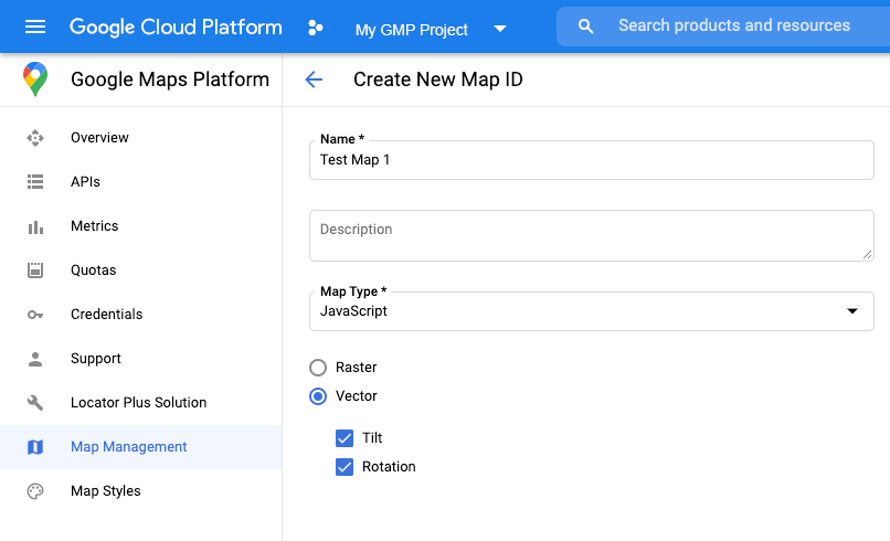
Puoi anche specificare il tipo di rendering utilizzando un ID mappa. Per creare un nuovo ID mappa, segui i passaggi descritti in Utilizzo della personalizzazione basata su cloud: ottieni un ID mappa.
Assicurati di impostare il tipo di mappa su JavaScript e seleziona l'opzione Vettoriale. Seleziona Inclinazione o Rotazione per attivare l'inclinazione e la rotazione sulla mappa. In questo modo puoi modificare questi valori a livello di programmazione e
consentire agli utenti di regolare l'inclinazione e la direzione direttamente sulla mappa. Se l'utilizzo dell'inclinazione o
della direzione influirà negativamente sulla tua app, lascia Inclinazione e Rotazione deselezionati in modo che gli utenti non possano regolare l'inclinazione e la rotazione.
Poi, aggiorna il codice di inizializzazione della mappa con l'ID mappa che hai creato. Puoi trovare
i tuoi ID mappa nella
pagina Gestione
mappe. Fornisci un ID mappa quando la istanzi utilizzando la proprietà
mapId come mostrato qui:
Le mappe vettoriali, l'inclinazione e la direzione sono attivate per impostazione predefinita quando utilizzi l'elemento <gmp-map>, che ti consente di aggiungere una mappa alla tua pagina utilizzando HTML. Scopri di più.
Esempi
Sono stati forniti esempi per dimostrare queste funzionalità:
[null,null,["Ultimo aggiornamento 2025-08-31 UTC."],[[["\u003cp\u003eWebGL-powered features for Maps JavaScript API enable control over tilt and rotation, addition of 3D objects, and custom 2D/3D graphics with WebGL Overlay View.\u003c/p\u003e\n"],["\u003cp\u003eTo utilize WebGL features, use a vector map by specifying \u003ccode\u003erenderingType: RenderingType.VECTOR\u003c/code\u003e during map initialization or by using a map ID with the vector option enabled.\u003c/p\u003e\n"],["\u003cp\u003eTilt and rotation can be controlled programmatically or through user interaction by enabling \u003ccode\u003etiltInteractionEnabled\u003c/code\u003e and \u003ccode\u003eheadingInteractionEnabled\u003c/code\u003e map options.\u003c/p\u003e\n"],["\u003cp\u003eThe \u003ccode\u003e<gmp-map>\u003c/code\u003e element automatically enables vector maps, tilt, and heading by default, simplifying integration.\u003c/p\u003e\n"],["\u003cp\u003eSeveral examples and demos are available to explore the capabilities and implementation of WebGL features in Maps JavaScript API.\u003c/p\u003e\n"]]],[],null,["\u003cbr /\u003e\n\nWebGL-powered features for Maps JavaScript API let you\ncontrol tilt and rotation, add 3D objects directly to the map, and more. The\nfollowing features are included:\n\n- [WebGL Overlay View](/maps/documentation/javascript/webgl/webgl-overlay-view) lets you add custom 2D and 3D graphics and animated content to your maps.\n- [Tilt and heading](/maps/documentation/javascript/vector-map#tilt-rotation) can now be adjusted programmatically, and by using mouse and keyboard gestures.\n- [map.moveCamera()](/maps/documentation/javascript/vector-map#control-camera) lets you simultaneously change multiple camera properties.\n- Zoom now supports [fractional values](/maps/documentation/javascript/vector-map#fractional-zoom).\n\nGet started\n\nIn order to use the new WebGL features, you must use a vector map. This section\nshows you how.\n\nSpecify the `renderingType` option\n\nUse the `renderingType` option to specify either the raster or vector\nrendering type for your map (no map ID required):\n\n1. Load the `RenderingType` library; this can be done when loading the Maps\n library:\n\n const { Map, RenderingType } = await google.maps.importLibrary(\"maps\") as google.maps.MapsLibrary;\n\n2. When initializing the map, use the `renderingType` option to specify either\n `RenderingType.VECTOR` or `RenderingType.RASTER`:\n\n map = new Map(\n document.getElementById('map') as HTMLElement,\n {\n zoom: 4,\n center: position,\n renderingType: RenderingType.VECTOR,\n }\n );\n\nThe `renderingType` option overrides any rendering type settings made by\nconfiguring a map ID.\n\n- To enable tilt and rotation, set the `tiltInteractionEnabled` map option to true or call `map.setTiltInteractionEnabled`.\n- To enable panning, set the `headingInteractionEnabled` map option to `true` or call `map.setHeadingInteractionEnabled`.\n\nUse a map ID to set rendering type\n\nYou can also specify the rendering type by using a map ID. To create a new map\nID, follow the steps in [Using Cloud-based Map Styling - Get a map ID](/maps/documentation/javascript/styling#creating-map-ids).\nBe sure to set the Map type to **JavaScript** , and select the **Vector**\noption. Check **Tilt** or **Rotation** to enable tilt and rotation on the\nmap. Doing so lets you programmatically adjust these values, and also\nlets users adjust tilt and heading directly on the map. If the use of tilt or\nheading will adversely affect your app, leave **Tilt** and **Rotation** un-\nchecked so users cannot adjust tilt and rotation.\n\nNext, update your map initialization code with the map ID you created. You can\nfind your map IDs on the\n[Maps\nManagement](https://console.cloud.google.com/google/maps-apis/studio/maps) page. Provide a map ID when you instantiate the map using the\n`mapId` property as shown here: \n\n```javascript\nmap = new google.maps.Map(document.getElementById('map'), {\n center: {lat: -34.397, lng: 150.644},\n zoom: 8,\n mapId: '\u003cvar translate=\"no\"\u003eMAP_ID\u003c/var\u003e'\n});\n```\n| **Important:** It is recommended to associate your map ID and API key with the same Google Cloud console project.\n\nUse the `\u003cgmp-map\u003e` element\n\nVector maps, tilt, and heading are enabled by default when using he `\u003cgmp-map\u003e`\nelement, which lets you add a map to your page using HTML. [Learn more](/maps/documentation/javascript/add-google-map-wc-tut).\n\nExamples\n\nExamples have been provided to demonstrate these features:\n\n- [WebGL Overlay View](/maps/documentation/javascript/examples/webgl/webgl-overlay-simple)\n- [WebGL Tilt and Rotation](/maps/documentation/javascript/examples/webgl/webgl-tilt-rotation)\n- [WebGL Feature Tour](https://goo.gle/maps-platform-webgl-tour)\n- [WebGL Travel App Demo](https://goo.gle/maps-platform-webgl-travel-demo)"]]