The Real-Time Mesoscale Analysis (RTMA) is a high-spatial and temporal
resolution analysis for near-surface weather conditions. This dataset
includes hourly analyses at 2.5 km for CONUS.
Bands
Pixel Size 2500 meters
Bands
Name
Units
Min
Max
Pixel Size
Description
HGT
m
-81*
4226*
meters
Model terrain elevation
PRES
Pa
60848*
105183*
meters
Pressure
TMP
°C
-43.2*
43.73*
meters
Temperature
DPT
°C
-81.41*
30.92*
meters
Dew point temperature
UGRD
m/s
-32.93*
34.04*
meters
U-component of wind
VGRD
m/s
-28.44*
39.21*
meters
V-component of wind
SPFH
Mass fraction
0*
0.02*
meters
Specific humidity
WDIR
deg
0*
360*
meters
Wind direction (from which blowing)
WIND
m/s
0*
42.46*
meters
Wind speed
GUST
m/s
0*
58.02*
meters
Wind speed (gust)
VIS
m
0*
20000*
meters
Visibility
TCDC
%
0*
100*
meters
Total cloud cover
ACPC01
kg/m^2
0*
1*
meters
Total precipitation
* estimated min or max value
Terms of Use
Terms of Use
NOAA data, information, and products, regardless of the method of delivery,
are not subject to copyright and carry no restrictions on their subsequent
use by the public. Once obtained, they may be put to any lawful use. The
forgoing data is in the public domain and is being provided without
restriction on use and distribution. For more information visit the
NWS disclaimer site.
The Real-Time Mesoscale Analysis (RTMA) is a high-spatial and temporal resolution analysis for near-surface weather conditions. This dataset includes hourly analyses at 2.5 km for CONUS.
[null,null,[],[[["\u003cp\u003eThe Real-Time Mesoscale Analysis (RTMA) dataset provides hourly, 2.5 km resolution analyses of near-surface weather conditions for the Continental US (CONUS).\u003c/p\u003e\n"],["\u003cp\u003eIt includes various weather parameters like temperature, wind speed, humidity, precipitation, and cloud cover.\u003c/p\u003e\n"],["\u003cp\u003eThe dataset is freely available for use without restrictions, provided by NOAA/NWS.\u003c/p\u003e\n"],["\u003cp\u003eIt covers the period from January 1, 2011, to December 12, 2024.\u003c/p\u003e\n"],["\u003cp\u003eUsers can explore and analyze the RTMA dataset using Google Earth Engine.\u003c/p\u003e\n"]]],["The NOAA/NWS RTMA dataset provides hourly, 2.5 km resolution analyses of near-surface weather conditions for CONUS from 2011-01-01 to 2025-02-22. It includes data on pressure, temperature, dew point, wind (speed, direction, and components), humidity, cloud cover, and precipitation, among other parameters. The data, provided by NOAA/NWS, is available via Google Earth Engine and is free to use without restriction. The dataset is updated every hour, with a pixel size of 2500 meters.\n"],null,["Dataset Availability\n: 2011-01-01T00:00:00Z--2025-09-01T18:00:00Z\n\nDataset Provider\n:\n\n\n [NOAA/NWS](https://www.nco.ncep.noaa.gov/pmb/products/rtma/)\n\nCadence\n: 1 Hour\n\nTags\n:\n [atmosphere](/earth-engine/datasets/tags/atmosphere) [climate](/earth-engine/datasets/tags/climate) [cloud](/earth-engine/datasets/tags/cloud) [geophysical](/earth-engine/datasets/tags/geophysical) [humidity](/earth-engine/datasets/tags/humidity) [noaa](/earth-engine/datasets/tags/noaa) [nws](/earth-engine/datasets/tags/nws) [precipitation](/earth-engine/datasets/tags/precipitation) [pressure](/earth-engine/datasets/tags/pressure) [surface](/earth-engine/datasets/tags/surface) [temperature](/earth-engine/datasets/tags/temperature) [weather](/earth-engine/datasets/tags/weather) [wind](/earth-engine/datasets/tags/wind) \n rtma \nvisibility \n\nDescription \nThe Real-Time Mesoscale Analysis (RTMA) is a high-spatial and temporal\nresolution analysis for near-surface weather conditions. This dataset\nincludes hourly analyses at 2.5 km for CONUS.\n\nBands\n\n\n**Pixel Size**\n\n2500 meters\n\n**Bands**\n\n| Name | Units | Min | Max | Pixel Size | Description |\n|----------|---------------|----------|----------|------------|-------------------------------------|\n| `HGT` | m | -81\\* | 4226\\* | meters | Model terrain elevation |\n| `PRES` | Pa | 60848\\* | 105183\\* | meters | Pressure |\n| `TMP` | °C | -43.2\\* | 43.73\\* | meters | Temperature |\n| `DPT` | °C | -81.41\\* | 30.92\\* | meters | Dew point temperature |\n| `UGRD` | m/s | -32.93\\* | 34.04\\* | meters | U-component of wind |\n| `VGRD` | m/s | -28.44\\* | 39.21\\* | meters | V-component of wind |\n| `SPFH` | Mass fraction | 0\\* | 0.02\\* | meters | Specific humidity |\n| `WDIR` | deg | 0\\* | 360\\* | meters | Wind direction (from which blowing) |\n| `WIND` | m/s | 0\\* | 42.46\\* | meters | Wind speed |\n| `GUST` | m/s | 0\\* | 58.02\\* | meters | Wind speed (gust) |\n| `VIS` | m | 0\\* | 20000\\* | meters | Visibility |\n| `TCDC` | % | 0\\* | 100\\* | meters | Total cloud cover |\n| `ACPC01` | kg/m\\^2 | 0\\* | 1\\* | meters | Total precipitation |\n\n\\* estimated min or max value\n\nTerms of Use\n\n**Terms of Use**\n\nNOAA data, information, and products, regardless of the method of delivery,\nare not subject to copyright and carry no restrictions on their subsequent\nuse by the public. Once obtained, they may be put to any lawful use. The\nforgoing data is in the public domain and is being provided without\nrestriction on use and distribution. For more information visit the\n[NWS disclaimer site](https://www.weather.gov/disclaimer/).\n\nExplore with Earth Engine **Important:** Earth Engine is a platform for petabyte-scale scientific analysis and visualization of geospatial datasets, both for public benefit and for business and government users. Earth Engine is free to use for research, education, and nonprofit use. To get started, please [register for Earth Engine access.](https://console.cloud.google.com/earth-engine)\n\n
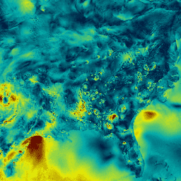
Code Editor (JavaScript) \n\n```javascript\nvar dataset = ee.ImageCollection('NOAA/NWS/RTMA')\n .filter(ee.Filter.date('2018-03-01', '2018-03-02'));\nvar windSpeed = dataset.select('WIND');\nvar windSpeedVis = {\n min: 0.0,\n max: 12.0,\n palette: ['001137', '01abab', 'e7eb05', '620500'],\n};\nMap.setCenter(-95.62, 39.91, 4);\nMap.addLayer(windSpeed, windSpeedVis, 'Wind Speed');\n```\n[Open in Code Editor](https://code.earthengine.google.com/?scriptPath=Examples:Datasets/NOAA/NOAA_NWS_RTMA) \n[RTMA: Real-Time Mesoscale Analysis](/earth-engine/datasets/catalog/NOAA_NWS_RTMA) \nThe Real-Time Mesoscale Analysis (RTMA) is a high-spatial and temporal resolution analysis for near-surface weather conditions. This dataset includes hourly analyses at 2.5 km for CONUS. \nNOAA/NWS/RTMA, atmosphere,climate,cloud,geophysical,humidity,noaa,nws,precipitation,pressure,surface,temperature,weather,wind \n2011-01-01T00:00:00Z/2025-09-01T18:00:00Z \n20.15 -130.17 52.91 -60.81 \nGoogle Earth Engine \nhttps://developers.google.com/earth-engine/datasets\n\n- [](https://doi.org/https://www.nco.ncep.noaa.gov/pmb/products/rtma/)\n- [](https://doi.org/https://developers.google.com/earth-engine/datasets/catalog/NOAA_NWS_RTMA)"]]