-
オーストラリアの実際の蒸発散量(CMRSET Landsat V2.2)
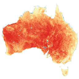
このデータセットは、CMRSET アルゴリズムを使用して、オーストラリアの実際の蒸発散量(AET または ETa)を正確に提供します。AET バンド(ETa という名前)には、その月のすべての雲のない Landsat 観測の CMRSET モデルの 1 日あたりの平均値が含まれます(AET データの値 3 で示されます)。 農業 オーストラリア CSIRO 蒸発 蒸発散 LANDSAT 由来 -
オーストラリア 5M DEM
LiDAR モデルから派生したオーストラリアのデジタル標高モデル(DEM)5 メートル グリッドは、2001 年から 2015 年にかけて 245,000 平方キロメートルを超える範囲をカバーする 236 件の個々の LiDAR 調査から派生した、全国 5 メートル(地表)DEM を表します。… オーストラリア dem elevation elevation-topography ga geophysical -
DEM-H: オーストラリア SRTM 水理的に適用されたデジタル標高モデル
水理的に適用されたデジタル標高モデル(DEM-H)は、2000 年 2 月に NASA が取得した SRTM データから派生したものです。モデルは水理的に条件付けられ、排水が適用されています。DEM-H は、SRTM の標高とマッピングされたストリームラインに基づいて流路をキャプチャし、次のような境界線の描画に対応しています。 オーストラリア dem elevation elevation-topography ga geophysical -
DEM-S: オーストラリアの滑らか化されたデジタル標高モデル
スムーズ化デジタル標高モデル(DEM-S)は、2000 年 2 月に NASA が取得した SRTM データから派生したものです。DEM-S は地表地形(植生対象物は除く)を表し、ノイズを低減して地表形状の表現を改善するためにスムージングされています。適応型プロセスにより、より多くの オーストラリア dem elevation elevation-topography ga geophysical -
国立干潟デジタル標高モデル 25 m 1.0.0 プレビュー
ナショナル インタータイド デジタル標高モデル(NIDEM、Bishop-Taylor 他 2018、2019)は、オーストラリアの露出している干潮帯の大陸規模の標高データセットです。NIDEM は、オーストラリアの干潮時の砂浜や海岸、干潟、岩場、サンゴ礁を 25 m の解像度で初めて立体的に表現しています。 australia dem elevation-topography ga -
SLGA: オーストラリアの土壌と地形のグリッド(土壌属性)
オーストラリアの土壌と地形のグリッド(SLGA)は、オーストラリア全土の土壌属性に関する包括的なデータセットで、解像度は 3 秒角(約 90 m ピクセル)です。サーフェスは、既存の土壌データと環境データを使用して土壌属性の空間分布を記述するモデリングの結果です。 オーストラリア csiro soil tern
Datasets tagged australia in Earth Engine
[null,null,[],[[["\u003cp\u003eThis collection provides access to a variety of geospatial datasets focusing on Australia, including elevation models, land cover classifications, and water observations.\u003c/p\u003e\n"],["\u003cp\u003eDatasets are derived from various sources like LiDAR, SRTM, Landsat, and CMRSET, offering different resolutions and temporal coverage.\u003c/p\u003e\n"],["\u003cp\u003eGeoscience Australia and CSIRO are key providers of data, enabling analysis of Australia's terrain, soil, and water resources.\u003c/p\u003e\n"],["\u003cp\u003eDEA products offer insights into long-term environmental changes and conditions by leveraging extensive satellite imagery archives.\u003c/p\u003e\n"],["\u003cp\u003eUsers can explore Australia's intertidal zones through NIDEM, a detailed elevation model, and soil properties through SLGA, a comprehensive soil attribute dataset.\u003c/p\u003e\n"]]],["Several datasets provide detailed geographic and environmental information about Australia. Digital Elevation Models (DEMs) include a 5-meter grid from LiDAR surveys, a hydrologically enforced model, and a smoothed model from SRTM data, as well as a national intertidal DEM. Additional data includes the Soil and Landscape Grid of Australia (SLGA) with soil attributes. Landsat data is processed to show actual evapotranspiration (AET), land cover, water observations, and statistical analysis.\n"],null,["# Datasets tagged australia in Earth Engine\n\n-\n\n |-------------------------------------------------------------------------------------------------------------------------------------------------------------------------------------------------------------------------------------------------------------------------------------------------------------------------------------------------|\n | [### Actual Evapotranspiration for Australia (CMRSET Landsat V2.2)](/earth-engine/datasets/catalog/TERN_AET_CMRSET_LANDSAT_V2_2) |\n | This dataset provides accurate actual evapotranspiration (AET or ETa) for Australia using the CMRSET algorithm. The AET band (named 'ETa') contains the average daily value from the CMRSET model for all cloud-free Landsat observations in that month (indicated with value 3 in the AET Data ... |\n | [agriculture](/earth-engine/datasets/tags/agriculture) [australia](/earth-engine/datasets/tags/australia) [csiro](/earth-engine/datasets/tags/csiro) [evaporation](/earth-engine/datasets/tags/evaporation) [evapotranspiration](/earth-engine/datasets/tags/evapotranspiration) [landsat-derived](/earth-engine/datasets/tags/landsat-derived) |\n\n-\n\n |-------------------------------------------------------------------------------------------------------------------------------------------------------------------------------------------------------------------------------------------------------------------------------------------------------------------|\n | [### Australian 5M DEM](/earth-engine/datasets/catalog/AU_GA_AUSTRALIA_5M_DEM) |\n | The Digital Elevation Model (DEM) 5 meter Grid of Australia derived from LiDAR model represents a National 5 meter (bare earth) DEM which has been derived from some 236 individual LiDAR surveys between 2001 and 2015 covering an area in excess of 245,000 square kilometers. ... |\n | [australia](/earth-engine/datasets/tags/australia) [dem](/earth-engine/datasets/tags/dem) [elevation](/earth-engine/datasets/tags/elevation) [elevation-topography](/earth-engine/datasets/tags/elevation-topography) [ga](/earth-engine/datasets/tags/ga) [geophysical](/earth-engine/datasets/tags/geophysical) |\n\n-\n\n |--------------------------------------------------------------------------------------------------------------------------------------------------------------------------------------------------------------------------------------------------------------------------------------------------------------------|\n | [### DEM-H: Australian SRTM Hydrologically Enforced Digital Elevation Model](/earth-engine/datasets/catalog/AU_GA_DEM_1SEC_v10_DEM-H) |\n | The Hydrologically Enforced Digital Elevation Model (DEM-H) was derived from the SRTM data acquired by NASA in February 2000. The model has been hydrologically conditioned and drainage enforced. The DEM-H captures flow paths based on SRTM elevations and mapped stream lines, and supports delineation of ... |\n | [australia](/earth-engine/datasets/tags/australia) [dem](/earth-engine/datasets/tags/dem) [elevation](/earth-engine/datasets/tags/elevation) [elevation-topography](/earth-engine/datasets/tags/elevation-topography) [ga](/earth-engine/datasets/tags/ga) [geophysical](/earth-engine/datasets/tags/geophysical) |\n\n-\n\n |-----------------------------------------------------------------------------------------------------------------------------------------------------------------------------------------------------------------------------------------------------------------------------------------------------------------------|\n | [### DEM-S: Australian Smoothed Digital Elevation Model](/earth-engine/datasets/catalog/AU_GA_DEM_1SEC_v10_DEM-S) |\n | The Smoothed Digital Elevation Model (DEM-S) was derived from the SRTM data acquired by NASA in February 2000. DEM-S represents ground surface topography (excluding vegetation features) and has been smoothed to reduce noise and improve the representation of surface shape. An adaptive process applied more ... |\n | [australia](/earth-engine/datasets/tags/australia) [dem](/earth-engine/datasets/tags/dem) [elevation](/earth-engine/datasets/tags/elevation) [elevation-topography](/earth-engine/datasets/tags/elevation-topography) [ga](/earth-engine/datasets/tags/ga) [geophysical](/earth-engine/datasets/tags/geophysical) |\n\n-\n\n |---------------------------------------------------------------------------------------------------------------------------------------------------------------------------------------------------------------------------------------------------------------------------------------------------------------------------------------------|\n | [### Preview National Intertidal Digital Elevation Model 25m 1.0.0](/earth-engine/datasets/catalog/projects_ngis-cat_assets_DEA_NIDEM) |\n | The National Intertidal Digital Elevation Model (NIDEM; Bishop-Taylor et al. 2018, 2019) is a continental-scale elevation dataset for Australia's exposed intertidal zone. NIDEM provides the first three-dimensional representation of Australia's intertidal sandy beaches and shores, tidal flats and rocky shores and reefs at 25 m ... |\n | [australia](/earth-engine/datasets/tags/australia) [dem](/earth-engine/datasets/tags/dem) [elevation-topography](/earth-engine/datasets/tags/elevation-topography) [ga](/earth-engine/datasets/tags/ga) |\n\n-\n\n |---------------------------------------------------------------------------------------------------------------------------------------------------------------------------------------------------------------------------------------------------------------------------------------------------------------------|\n | [### SLGA: Soil and Landscape Grid of Australia (Soil Attributes)](/earth-engine/datasets/catalog/CSIRO_SLGA) |\n | The Soil and Landscape Grid of Australia (SLGA) is a comprehensive dataset of soil attributes across Australia at 3 arc-second resolution (\\~90m pixels). The surfaces are the outcomes from modelling that describe the spatial distribution of the soil attributes using existing soil data and environmental ... |\n | [australia](/earth-engine/datasets/tags/australia) [csiro](/earth-engine/datasets/tags/csiro) [soil](/earth-engine/datasets/tags/soil) [tern](/earth-engine/datasets/tags/tern) |"]]