-
オーストラリアの実際の蒸発散量(CMRSET Landsat V2.2)
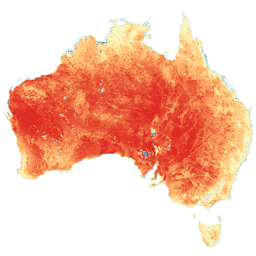
このデータセットは、CMRSET アルゴリズムを使用して、オーストラリアの正確な実際の蒸発散量(AET または ETa)を提供します。AET バンド(「ETa」という名前)には、その月の雲のない Landsat 観測すべてについて、CMRSET モデルから得られた 1 日あたりの平均値が含まれています(AET データで値 3 で示されています)。 agriculture australia csiro evaporation evapotranspiration landsat-derived -
SLGA: Soil and Landscape Grid of Australia(土壌属性)
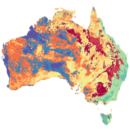
Soil and Landscape Grid of Australia(SLGA)は、オーストラリア全土の土壌属性に関する包括的なデータセットで、解像度は 3 アーク秒(約 90 m ピクセル)です。サーフェスは、既存の土壌データと環境データを使用して土壌属性の空間分布を記述するモデリングの結果です。 australia csiro soil tern
Datasets tagged tern in Earth Engine
[null,null,[],[],[]]