-
캐나다 AAFC 연간 작물 인벤토리
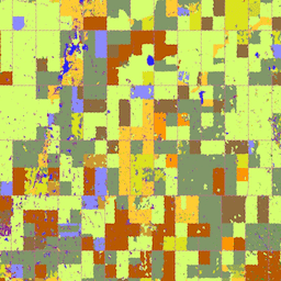
2009년부터 캐나다 농업식품부 (AAFC)의 과학기술부 (STB) 지구 관측팀은 연간 작물 유형 디지털 지도를 생성하는 절차를 시작했습니다. 2009년과 2010년에 캐나다 대초원 지역에 초점을 맞춘 의사결정 트리 (DT) 기반 방법론은 … agriculture canada crop landcover -
Canadian Digital Elevation Model
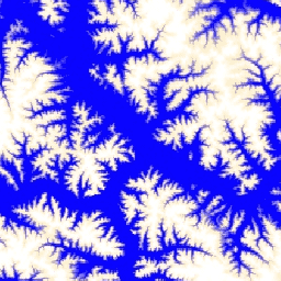
캐나다 디지털 고도 모델 (CDEM)은 캐나다 천연자원부 (NRCan)의 고도계 시스템의 일부이며 기존 캐나다 디지털 고도 데이터 (CDED)에서 파생되었습니다. 이러한 데이터에서 고도는 지면 또는 반사 표면 고도일 수 있습니다. CDEM은 다음과 같은 여러 DEM으로 구성됩니다. canada dem elevation elevation-topography geophysical topography -
캐나다 2019년 Landsat 기반 산림 연령
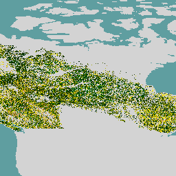
캐나다 원시림 데이터 세트는 30m 공간 해상도로 캐나다의 산림 생태 지역에 걸쳐 2019년의 위성 기반 산림 연령 지도입니다. Landsat (교란, 표면 반사율 합성, 산림 구조) 및 MODIS (총 일차 생산량)의 원격 감지 데이터가 연령을 결정하는 데 사용됩니다. 산림 연령은 … 캐나다 산림 산림-바이오매스 -
SCANFI: 공간화된 캐나다 국립 산림 인벤토리 데이터 제품1.2

이 데이터에는 2020년 캐나다 전역의 광범위한 토지 피복 유형, 산림 캐노피 높이, 수관 폐쇄도, 지상 나무 바이오매스를 나타내는 30m 해상도 래스터 파일과 여러 주요 수종의 종 구성이 포함되어 있습니다. The Spatialized CAnadian National … canada forest forest-biomass publisher-dataset tree-cover
Datasets tagged canada in Earth Engine
[null,null,[],[],["Agriculture and Agri-Food Canada (AAFC) initiated annual crop type mapping in 2009, starting with the Prairie Provinces, using a Decision Tree methodology. A 2019 satellite-based forest age map of Canada was created utilizing Landsat and MODIS data at a 30-meter resolution. Natural Resources Canada's (NRCan) Canadian Digital Elevation Model (CDEM), part of the altimetry system, provides elevation data comprising multiple Digital Elevation Models (DEMs).\n"]]