-
Limites de la zone brûlée MTBS

L'ensemble de données sur les limites des zones brûlées de la base de données MTBS (Monitoring Trends in Burn Severity) contient les polygones d'étendue des zones brûlées de tous les incendies MTBS actuellement terminés pour les États-Unis continentaux, l'Alaska, Hawaï et Porto Rico. "Below NBR" signifie "Normalized Burn Ratio" (ratio de brûlure normalisé), tandis que "dNBR" signifie … eros fire gtac mtbs table usda -
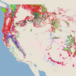
Images de gravité des brûlures (MTBS)

Les mosaïques de gravité des brûlures sont constituées d'images raster thématiques des classes de gravité des brûlures MTBS pour tous les incendies MTBS actuellement terminés pour les États-Unis continentaux, l'Alaska, Hawaï et Porto Rico. Les images mosaïquées de la gravité des brûlures sont compilées chaque année pour chaque État américain et … eros fire forest gtac landcover landsat-derived -
USFS Landscape Change Monitoring System v2024.10 (CONUS et OCONUS)
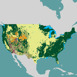
Ce produit fait partie de la suite de données du système de surveillance des changements de paysage (LCMS, Landscape Change Monitoring System). Il indique les classes de changement, de couverture et/ou d'utilisation des terres modélisées par LCMS pour chaque année et couvre les États-Unis continentaux (CONUS), ainsi que les zones en dehors des États-Unis continentaux (OCONUS), y compris l'Alaska (AK), Porto … change-detection forest gtac landcover landuse landuse-landcover -
USFS Tree Canopy Cover v2023-5 (CONUS and OCONUS)

Présentation La suite de données sur la couverture de la canopée (TCC, Tree Canopy Cover), produite par le service forestier du ministère américain de l'Agriculture (USFS, United States Department of Agriculture, Forest Service), est constituée de cartes annuelles basées sur la télédétection et couvrant la période allant de 1985 à 2023. Ces données soutiennent le projet National Land Cover Database (NLCD), géré par l'US Geological … forest gtac landuse-landcover redcastle-resources usda usfs -
TreeMap USFS v2016 (États-Unis contigus)

Ce produit fait partie de la suite de données TreeMap. Il fournit des informations spatiales détaillées sur les caractéristiques des forêts, y compris le nombre d'arbres vivants et morts, la biomasse et le carbone, pour l'ensemble de la superficie forestière des États-Unis continentaux en 2016. TreeMap v2016 contient une image, un … biomasse carbone changement-climatique conus forêt biomasse-forestière -
USFS TreeMap v2020

Ce produit fait partie de la suite de données TreeMap. Il fournit des informations spatiales détaillées sur les caractéristiques des forêts, y compris le nombre d'arbres vivants et morts, la biomasse et le carbone, pour l'ensemble des forêts des États-Unis en 2020. TreeMap v2020 contient 22 bandes de 30 x 30 m… aboveground biomass carbon climate-change conus forest -
TreeMap USFS v2022
Ce produit fait partie de la suite de données TreeMap. Il fournit des informations spatiales détaillées sur les caractéristiques des forêts, y compris le nombre d'arbres vivants et morts, la biomasse et le carbone, sur l'ensemble de la superficie forestière des États-Unis en 2022. TreeMap v2022 contient 22 bandes de 30 x 30 m… aboveground biomass carbon climate-change conus forest
Datasets tagged gtac in Earth Engine
[null,null,[],[],[]]