Page Summary
-
This dataset provides global uncalibrated Gross Primary Productivity (GPP) at 30-m spatial resolution from 2000 onwards, produced by the Land & Carbon Lab Global Pasture Watch initiative.
-
GPP values are modeled using a light use efficiency (LUE) approach, combining aggregated GLAD Landsat ARD with MODIS temperature and CERES Photosynthetically Active Radiation data.
-
The dataset offers annual uncalibrated GPP values and calculates Grassland GPP values on-the-fly through a GEE App.
-
Limitations of the dataset include input data resolution mismatch, data artifacts like vertical stripes, bi-monthly temporal resolution, and potential underestimation of Grassland GPP due to fixed LUEmax parameters.
-
The dataset is available from 2000 to 2024 and is licensed under CC-BY-4.0.
- Catalog Owner
- Global Pasture Watch
- Dataset Availability
- 2000-01-01T00:00:00Z–2024-01-01T00:00:00Z
- Dataset Producer
- Land and Carbon Lab Global Pasture Watch
- Contact
- Land & Carbon Lab
- Cadence
- 1 Year
- Tags
Description
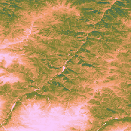
This dataset provides global uncalibrated EO-based Gross Primary Productivity from 2000 at 30-m spatial resolution. Produced by the Land & Carbon Lab Global Pasture Watch initiative, the current dataset provides Gross Primary Productivity (GPP) values globally at 30-m spatial resolution from 2000 onwards. GPP values are modeled via a light use efficiency (LUE) approach, where GLAD Landsat ARD (collection-2) are aggregated every two months (Consoli et al., 2024) and combined with 1-km MODIS temperature data and 1° CERES Photosynthetically Active Radiation (PAR).
To keep the dataset flexible, the maximum light use efficiency (LUEmax) is set to 1 gC/m²/day/MJ for all land cover types, allowing the users to later calibrate the GPP values according to specific land cover maps or regional conditions.
Bi-monthly uncalibrated Gross Primary Productivity (uGPP) values (available in OpenLandMap STAC) are averaged by each year and accumulated over the full 365-day period to produce global annual uGPP values, expressed in units of gC/m²/year.
Grassland GPP values are computed on-the-fly using GEE App.
Limitations:
Input data resolution mismatch: The dataset is provided at 30 m resolution, but key input variables for temperature (MOD11A1) and photosynthetically active radiation (CERES PAR) were derived from much coarser products (1 km and ~111 km, respectively). The downscaling of this information can introduce uncertainty and may not capture fine-scale microclimatic conditions affecting plant productivity.
Data artifacts: The dataset contains known visual artifacts, including vertical stripes ("stripe effect") in some areas, which are a result of issues with the Landsat 7 sensor (Scan Line Corrector failure) and the subsequent gap-filling process used to create the underlying reflectance archive (Consoli et al., 2024). These artifacts can disrupt the spatial continuity of GPP estimates during cloudy and snow cover periods
Temporal resolution: The data is produced at a bimonthly temporal resolution. This timeframe may not be sufficient to capture key growth periods or a plant's rapid responses (intense rainfall) to environmental changes, making it difficult to accurately capture productivity peaks and seasonal variation.
Grassland calibration: Grassland GPP values are calculated using a single maximum light use efficiency (LUEmax) parameter (0.86 gC/m²/year/MJ) for all global grasslands, based on the MOD17 algorithm. This value is not optimized for specific grassland types or local conditions. As a result, the model shows a tendency to underestimate GPP when compared to ground-based flux tower measurements.
Dependence on grassland maps accuracy: The accuracy of the grassland GPP values is contingent on the accuracy of the underlying GPW grassland maps. Any misclassification of land cover in the source maps (e.g., shrublands or croplands identified as grassland) will lead to corresponding errors in the GPP estimates for those locations.
For more information see Isik et. al, 2025, Zenodo and Global Pasture Watch GitHub site
Bands
Bands
Pixel size: 30 meters (all bands)
| Name | Min | Max | Pixel Size | Description |
|---|---|---|---|---|
gc_m2 |
0 | 4000 | 30 meters | Grams of carbon per square meter per year (gC/m²/year) |
Image Properties
Image Properties
| Name | Type | Description |
|---|---|---|
| version | INT | Product version |
Terms of Use
Terms of Use
Citations
Isik, M. S., Mesquita, V., Parente, L., & Consoli, D. (2025). Global Pasture Watch - Source Code of the Global Uncalibrated EO-based GPP and Grassland GPP Maps at 30m. Zenodo. [Source code]. Zenodo doi:https://doi.org/10.5281/zenodo.15675358
Isik MS, Parente L, Consoli D, et al. (2025). Light use efficiency (LUE) based bimonthly gross primary productivity (GPP) for global grasslands at 30 m spatial resolution (2000–2022), PeerJ. doi: https://doi.org/10.7717/peerj.19774
DOIs
Explore with Earth Engine
Code Editor (JavaScript)
Map.setCenter(-49.265188, -16.602052, 4);

var ugppVis = {min: 0, max: 4000, palette: "faccfa,f19d6b,828232,226061,011959"}
var ugpp = ee.ImageCollection(
    "projects/global-pasture-watch/assets/ggpp-30m/v1/ugpp_m"
)

var ugpp2024 = ugpp.filterDate('2024-01-01', '2025-01-01').first();
Map.addLayer(ugpp2024, ugppVis, 'Uncalibrated GPP (2024)');

var ugpp2000 = ugpp.filterDate('2000-01-01', '2001-01-01').first();
Map.addLayer(ugpp2000, ugppVis, 'Uncalibrated GPP (2000)');