Page Summary
-
The BLM AIM TerrADat dataset contains field information collected since 2011 to inform land health, with over 6,000 terrestrial AIM field plots collected over BLM lands.
-
The NLCD 2019 dataset is a 30-m Landsat-based land cover database with data spanning 8 epochs from 2001 to 2019.
-
The NLCD 2021 dataset is one of seven National Land Cover Database products released by the USGS in partnership with federal agencies, covering two-to-three-year intervals since the 2016 release.
-
BLM AIM TerrADat TerrestrialAIM Point v1
Since 2011, the Bureau of Land Management (BLM) has collected field information to inform land health through its Assessment Inventory and Monitoring (AIM) strategy. To date, more than 6,000 terrestrial AIM field plots have been collected over BLM lands. The BLM AIM data archive is … blm ecosystems hydrology range soil table -
NLCD 2019: USGS National Land Cover Database, 2019 release
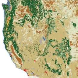
NLCD (the National Land Cover Database) is a 30-m Landsat-based land cover database spanning 8 epochs (2001, 2004, 2006, 2008, 2011, 2013, 2016, and 2019). A ninth epoch for 2021 is also available here. The images rely on the imperviousness data layer for the urban … blm landcover landuse-landcover mrlc nlcd usgs -
NLCD 2021: USGS National Land Cover Database, 2021 release
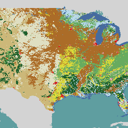
The U.S. Geological Survey (USGS), in partnership with several federal agencies, has now developed and released seven National Land Cover Database (NLCD) products: NLCD 1992, 2001, 2006, 2011, 2016, 2019, and 2021. Beginning with the 2016 release, land cover products were created for two-to-three-year intervals … blm landcover landuse-landcover mrlc nlcd usgs