Page Summary
-
Agriculture and Agri-Food Canada generates annual crop type digital maps for Canada starting in 2009.
-
The Canadian Digital Elevation Model provides ground or reflective surface elevations across Canada.
-
A 2019 Landsat-derived forest age map for Canada's forested ecozones is available at 30-m resolution.
-
The SCANFI data product contains 2020 Canadian wall-to-wall maps of broad land cover type, forest characteristics, and species composition at 30m resolution.
-
Canada AAFC Annual Crop Inventory
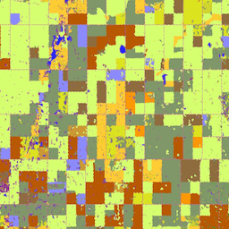
Starting in 2009, the Earth Observation Team of the Science and Technology Branch (STB) at Agriculture and Agri-Food Canada (AAFC) began the process of generating annual crop type digital maps. Focusing on the Prairie Provinces in 2009 and 2010, a Decision Tree (DT) based methodology … agriculture canada crop landcover -
Canadian Digital Elevation Model
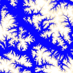
The Canadian Digital Elevation Model (CDEM) is part of Natural Resources Canada's (NRCan) altimetry system and stems from the existing Canadian Digital Elevation Data (CDED). In these data, elevations can be either ground or reflective surface elevations. The CDEM is comprised of multiple DEMs with … canada dem elevation elevation-topography geophysical topography -
Landsat-derived forest age for Canada 2019
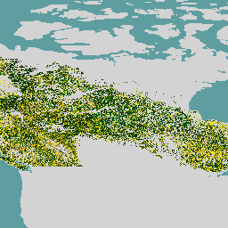
Canadian primary forest dataset is a satellite-based forest age map for 2019 across Canada's forested ecozones at a 30-m spatial resolution. Remotely-sensed data from Landsat (disturbances, surface reflectance composites, forest structure) and MODIS (Gross Primary Production) are utilized to determine age. Forest age can be … canada forest forest-biomass -
SCANFI: the Spatialized CAnadian National Forest Inventory data product1.2
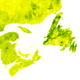
This data publication contains a set of 30m resolution raster files representing 2020 Canadian wall-to-wall maps of broad land cover type, forest canopy height, degree of crown closure and aboveground tree biomass, along with species composition of several major tree species. The Spatialized CAnadian National … canada forest forest-biomass publisher-dataset tree-cover