Page Summary
-
The Bureau of Land Management (BLM) collects field information through its AIM strategy to inform land health, with over 6,000 terrestrial AIM field plots collected since 2011.
-
The GLOBathy dataset provides detailed bathymetric maps for over 1.4 million waterbodies globally, harmonized with the HydroLAKES dataset.
-
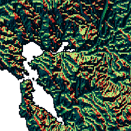
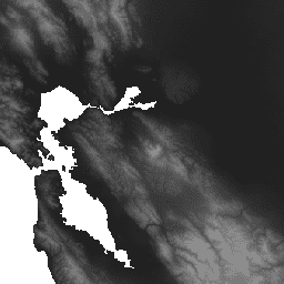
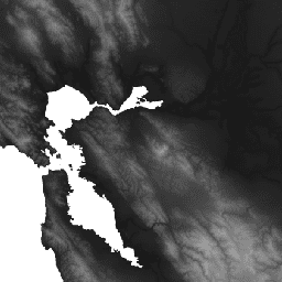
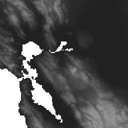
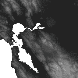
The USGS Watershed Boundary Dataset (WBD) is a comprehensive collection of hydrologic unit data defining surface water drainage extent.
-
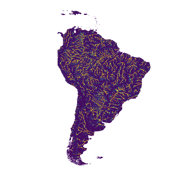
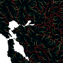
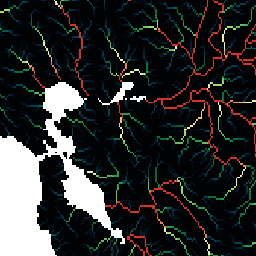
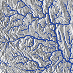
HydroSHEDS is a mapping product offering consistent hydrographic information at various scales, including river networks, watershed boundaries, drainage directions, and flow accumulations.
-
BLM AIM TerrADat TerrestrialAIM Point v1
Since 2011, the Bureau of Land Management (BLM) has collected field information to inform land health through its Assessment Inventory and Monitoring (AIM) strategy. To date, more than 6,000 terrestrial AIM field plots have been collected over BLM lands. The BLM AIM data archive is … blm ecosystems hydrology range soil table -
GLOBathy Global lakes bathymetry dataset
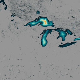
The GLObal Bathymetric (GLOBathy) dataset, comprising data on over 1.4 million waterbodies globally, has been meticulously developed to harmonize with the widely recognized HydroLAKES dataset. Utilizing a sophisticated Geographic Information System (GIS)-based framework, GLOBathy constructs detailed bathymetric maps by integrating maximum depth estimates and geometric/geophysical … bathymetry community-dataset hydrology sat-io surface-ground-water -
HUC02: USGS Watershed Boundary Dataset of Regions

The Watershed Boundary Dataset (WBD) is a comprehensive aggregated collection of hydrologic unit (HU) data consistent with the national criteria for delineation and resolution. It defines the areal extent of surface water drainage to a point except in coastal or lake front areas where there … hydrology surface-ground-water table usgs water watershed -
HUC04: USGS Watershed Boundary Dataset of Subregions

The Watershed Boundary Dataset (WBD) is a comprehensive aggregated collection of hydrologic unit (HU) data consistent with the national criteria for delineation and resolution. It defines the areal extent of surface water drainage to a point except in coastal or lake front areas where there … hydrology surface-ground-water table usgs water watershed -
HUC06: USGS Watershed Boundary Dataset of Basins

The Watershed Boundary Dataset (WBD) is a comprehensive aggregated collection of hydrologic unit (HU) data consistent with the national criteria for delineation and resolution. It defines the areal extent of surface water drainage to a point except in coastal or lake front areas where there … hydrology surface-ground-water table usgs water watershed -
HUC08: USGS Watershed Boundary Dataset of Subbasins
The Watershed Boundary Dataset (WBD) is a comprehensive aggregated collection of hydrologic unit (HU) data consistent with the national criteria for delineation and resolution. It defines the areal extent of surface water drainage to a point except in coastal or lake front areas where there … hydrology surface-ground-water table usgs water watershed -
HUC10: USGS Watershed Boundary Dataset of Watersheds

The Watershed Boundary Dataset (WBD) is a comprehensive aggregated collection of hydrologic unit (HU) data consistent with the national criteria for delineation and resolution. It defines the areal extent of surface water drainage to a point except in coastal or lake front areas where there … hydrology surface-ground-water table usgs water watershed -
HUC12: USGS Watershed Boundary Dataset of Subwatersheds

The Watershed Boundary Dataset (WBD) is a comprehensive aggregated collection of hydrologic unit (HU) data consistent with the national criteria for delineation and resolution. It defines the areal extent of surface water drainage to a point except in coastal or lake front areas where there … hydrology surface-ground-water table usgs water watershed -
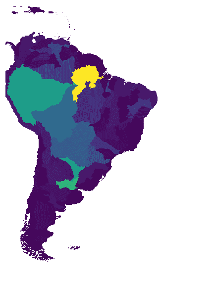
WWF HydroATLAS Basins Level 03
BasinATLAS is a component of the HydroATLAS database, which is a component of HydroSHEDS. BasinATLAS provides a standardized compendium of hydro-environmental attribute information for all watersheds of the world at high spatial resolution. This dataset includes data for 56 variables, partitioned into 281 attributes and … geophysical hydroatlas hydrography hydrology hydrosheds srtm -
WWF HydroATLAS Basins Level 04
BasinATLAS is a component of the HydroATLAS database, which is a component of HydroSHEDS. BasinATLAS provides a standardized compendium of hydro-environmental attribute information for all watersheds of the world at high spatial resolution. This dataset includes data for 56 variables, partitioned into 281 attributes and … geophysical hydroatlas hydrography hydrology hydrosheds srtm -
WWF HydroATLAS Basins Level 05
BasinATLAS is a component of the HydroATLAS database, which is a component of HydroSHEDS. BasinATLAS provides a standardized compendium of hydro-environmental attribute information for all watersheds of the world at high spatial resolution. This dataset includes data for 56 variables, partitioned into 281 attributes and … geophysical hydroatlas hydrography hydrology hydrosheds srtm -
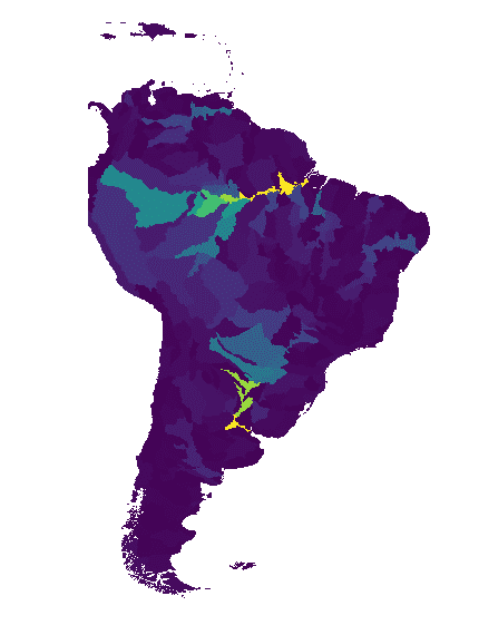
WWF HydroATLAS Basins Level 06
BasinATLAS is a component of the HydroATLAS database, which is a component of HydroSHEDS. BasinATLAS provides a standardized compendium of hydro-environmental attribute information for all watersheds of the world at high spatial resolution. This dataset includes data for 56 variables, partitioned into 281 attributes and … geophysical hydroatlas hydrography hydrology hydrosheds srtm -
WWF HydroATLAS Basins Level 07
BasinATLAS is a component of the HydroATLAS database, which is a component of HydroSHEDS. BasinATLAS provides a standardized compendium of hydro-environmental attribute information for all watersheds of the world at high spatial resolution. This dataset includes data for 56 variables, partitioned into 281 attributes and … geophysical hydroatlas hydrography hydrology hydrosheds srtm -
WWF HydroATLAS Basins Level 08
BasinATLAS is a component of the HydroATLAS database, which is a component of HydroSHEDS. BasinATLAS provides a standardized compendium of hydro-environmental attribute information for all watersheds of the world at high spatial resolution. This dataset includes data for 56 variables, partitioned into 281 attributes and … geophysical hydroatlas hydrography hydrology hydrosheds srtm -
WWF HydroATLAS Basins Level 09
BasinATLAS is a component of the HydroATLAS database, which is a component of HydroSHEDS. BasinATLAS provides a standardized compendium of hydro-environmental attribute information for all watersheds of the world at high spatial resolution. This dataset includes data for 56 variables, partitioned into 281 attributes and … geophysical hydroatlas hydrography hydrology hydrosheds srtm -
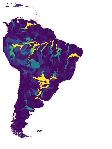
WWF HydroATLAS Basins Level 10
BasinATLAS is a component of the HydroATLAS database, which is a component of HydroSHEDS. BasinATLAS provides a standardized compendium of hydro-environmental attribute information for all watersheds of the world at high spatial resolution. This dataset includes data for 56 variables, partitioned into 281 attributes and … geophysical hydroatlas hydrography hydrology hydrosheds srtm -
WWF HydroATLAS Basins Level 11
BasinATLAS is a component of the HydroATLAS database, which is a component of HydroSHEDS. BasinATLAS provides a standardized compendium of hydro-environmental attribute information for all watersheds of the world at high spatial resolution. This dataset includes data for 56 variables, partitioned into 281 attributes and … geophysical hydroatlas hydrography hydrology hydrosheds srtm -
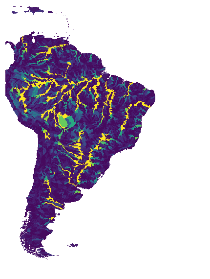
WWF HydroATLAS Basins Level 12
BasinATLAS is a component of the HydroATLAS database, which is a component of HydroSHEDS. BasinATLAS provides a standardized compendium of hydro-environmental attribute information for all watersheds of the world at high spatial resolution. This dataset includes data for 56 variables, partitioned into 281 attributes and … geophysical hydroatlas hydrography hydrology hydrosheds srtm -
WWF HydroSHEDS Basins Level 1

HydroSHEDS is a mapping product that provides hydrographic information for regional and global-scale applications in a consistent format. It offers a suite of geo-referenced datasets (vector and raster) at various scales, including river networks, watershed boundaries, drainage directions, and flow accumulations. HydroSHEDS is based on … geophysical hydrography hydrology hydrosheds srtm surface-ground-water -
WWF HydroSHEDS Basins Level 10

HydroSHEDS is a mapping product that provides hydrographic information for regional and global-scale applications in a consistent format. It offers a suite of geo-referenced datasets (vector and raster) at various scales, including river networks, watershed boundaries, drainage directions, and flow accumulations. HydroSHEDS is based on … geophysical hydrography hydrology hydrosheds srtm surface-ground-water -
WWF HydroSHEDS Basins Level 11

HydroSHEDS is a mapping product that provides hydrographic information for regional and global-scale applications in a consistent format. It offers a suite of geo-referenced datasets (vector and raster) at various scales, including river networks, watershed boundaries, drainage directions, and flow accumulations. HydroSHEDS is based on … geophysical hydrography hydrology hydrosheds srtm surface-ground-water -
WWF HydroSHEDS Basins Level 12

HydroSHEDS is a mapping product that provides hydrographic information for regional and global-scale applications in a consistent format. It offers a suite of geo-referenced datasets (vector and raster) at various scales, including river networks, watershed boundaries, drainage directions, and flow accumulations. HydroSHEDS is based on … geophysical hydrography hydrology hydrosheds srtm surface-ground-water -
WWF HydroSHEDS Basins Level 2

HydroSHEDS is a mapping product that provides hydrographic information for regional and global-scale applications in a consistent format. It offers a suite of geo-referenced datasets (vector and raster) at various scales, including river networks, watershed boundaries, drainage directions, and flow accumulations. HydroSHEDS is based on … geophysical hydrography hydrology hydrosheds srtm surface-ground-water -
WWF HydroSHEDS Basins Level 3

HydroSHEDS is a mapping product that provides hydrographic information for regional and global-scale applications in a consistent format. It offers a suite of geo-referenced datasets (vector and raster) at various scales, including river networks, watershed boundaries, drainage directions, and flow accumulations. HydroSHEDS is based on … geophysical hydrography hydrology hydrosheds srtm surface-ground-water -
WWF HydroSHEDS Basins Level 4

HydroSHEDS is a mapping product that provides hydrographic information for regional and global-scale applications in a consistent format. It offers a suite of geo-referenced datasets (vector and raster) at various scales, including river networks, watershed boundaries, drainage directions, and flow accumulations. HydroSHEDS is based on … geophysical hydrography hydrology hydrosheds srtm surface-ground-water -
WWF HydroSHEDS Basins Level 5

HydroSHEDS is a mapping product that provides hydrographic information for regional and global-scale applications in a consistent format. It offers a suite of geo-referenced datasets (vector and raster) at various scales, including river networks, watershed boundaries, drainage directions, and flow accumulations. HydroSHEDS is based on … geophysical hydrography hydrology hydrosheds srtm surface-ground-water -
WWF HydroSHEDS Basins Level 6

HydroSHEDS is a mapping product that provides hydrographic information for regional and global-scale applications in a consistent format. It offers a suite of geo-referenced datasets (vector and raster) at various scales, including river networks, watershed boundaries, drainage directions, and flow accumulations. HydroSHEDS is based on … geophysical hydrography hydrology hydrosheds srtm surface-ground-water -
WWF HydroSHEDS Basins Level 7
HydroSHEDS is a mapping product that provides hydrographic information for regional and global-scale applications in a consistent format. It offers a suite of geo-referenced datasets (vector and raster) at various scales, including river networks, watershed boundaries, drainage directions, and flow accumulations. HydroSHEDS is based on … geophysical hydrography hydrology hydrosheds srtm surface-ground-water -
WWF HydroSHEDS Basins Level 8

HydroSHEDS is a mapping product that provides hydrographic information for regional and global-scale applications in a consistent format. It offers a suite of geo-referenced datasets (vector and raster) at various scales, including river networks, watershed boundaries, drainage directions, and flow accumulations. HydroSHEDS is based on … geophysical hydrography hydrology hydrosheds srtm surface-ground-water -
WWF HydroSHEDS Basins Level 9

HydroSHEDS is a mapping product that provides hydrographic information for regional and global-scale applications in a consistent format. It offers a suite of geo-referenced datasets (vector and raster) at various scales, including river networks, watershed boundaries, drainage directions, and flow accumulations. HydroSHEDS is based on … geophysical hydrography hydrology hydrosheds srtm surface-ground-water -
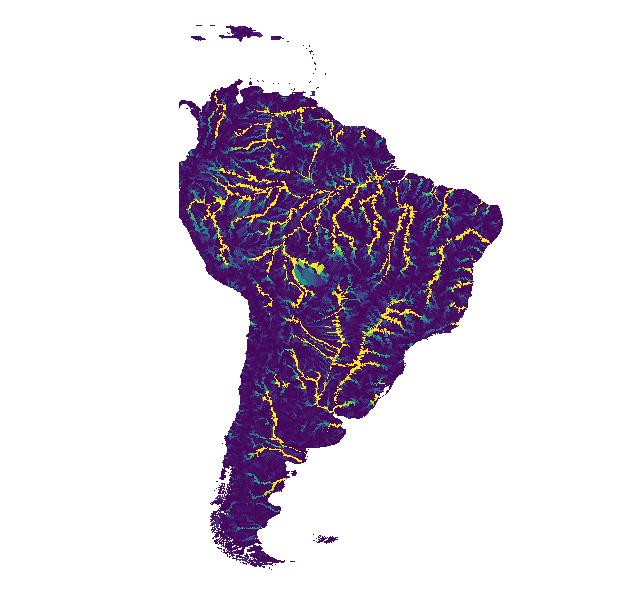
WWF HydroSHEDS Drainage Direction, 15 Arc-Seconds
HydroSHEDS is a mapping product that provides hydrographic information for regional and global-scale applications in a consistent format. It offers a suite of geo-referenced datasets (vector and raster) at various scales, including river networks, watershed boundaries, drainage directions, and flow accumulations. HydroSHEDS is based on … direction drainage flow geophysical hydrography hydrology -
WWF HydroSHEDS Drainage Direction, 3 Arc-Seconds
HydroSHEDS is a mapping product that provides hydrographic information for regional and global-scale applications in a consistent format. It offers a suite of geo-referenced datasets (vector and raster) at various scales, including river networks, watershed boundaries, drainage directions, and flow accumulations. HydroSHEDS is based on … direction drainage flow geophysical hydrography hydrology -
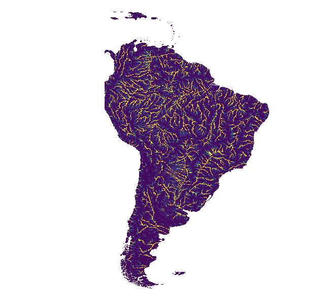
WWF HydroSHEDS Drainage Direction, 30 Arc-Seconds
HydroSHEDS is a mapping product that provides hydrographic information for regional and global-scale applications in a consistent format. It offers a suite of geo-referenced datasets (vector and raster) at various scales, including river networks, watershed boundaries, drainage directions, and flow accumulations. HydroSHEDS is based on … direction drainage flow geophysical hydrography hydrology -
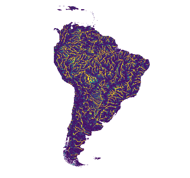
WWF HydroSHEDS Flow Accumulation, 15 Arc-Seconds
HydroSHEDS is a mapping product that provides hydrographic information for regional and global-scale applications in a consistent format. It offers a suite of geo-referenced datasets (vector and raster) at various scales, including river networks, watershed boundaries, drainage directions, and flow accumulations. HydroSHEDS is based on … accumulation drainage flow geophysical hydrography hydrology -
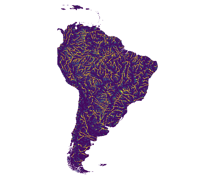
WWF HydroSHEDS Flow Accumulation, 30 Arc-Seconds
HydroSHEDS is a mapping product that provides hydrographic information for regional and global-scale applications in a consistent format. It offers a suite of geo-referenced datasets (vector and raster) at various scales, including river networks, watershed boundaries, drainage directions, and flow accumulations. HydroSHEDS is based on … accumulation drainage flow geophysical hydrography hydrology -
WWF HydroSHEDS Free Flowing Rivers Network v1
HydroSHEDS is a mapping product that provides hydrographic information for regional and global-scale applications in a consistent format. It offers a suite of geo-referenced datasets (vector and raster) at various scales, including river networks, watershed boundaries, drainage directions, and flow accumulations. HydroSHEDS is based on … geophysical hydrography hydrology hydrosheds srtm surface-ground-water -
WWF HydroSHEDS Hydrologically Conditioned DEM, 15 Arc-Seconds
HydroSHEDS is a mapping product that provides hydrographic information for regional and global-scale applications in a consistent format. It offers a suite of geo-referenced datasets (vector and raster) at various scales, including river networks, watershed boundaries, drainage directions, and flow accumulations. HydroSHEDS is based on … conditioned dem elevation geophysical hydrography hydrology -
WWF HydroSHEDS Hydrologically Conditioned DEM, 3 Arc-Seconds
HydroSHEDS is a mapping product that provides hydrographic information for regional and global-scale applications in a consistent format. It offers a suite of geo-referenced datasets (vector and raster) at various scales, including river networks, watershed boundaries, drainage directions, and flow accumulations. HydroSHEDS is based on … conditioned dem elevation geophysical hydrography hydrology -
WWF HydroSHEDS Hydrologically Conditioned DEM, 30 Arc-Seconds
HydroSHEDS is a mapping product that provides hydrographic information for regional and global-scale applications in a consistent format. It offers a suite of geo-referenced datasets (vector and raster) at various scales, including river networks, watershed boundaries, drainage directions, and flow accumulations. HydroSHEDS is based on … conditioned dem elevation geophysical hydrography hydrology -
WWF HydroSHEDS Void-Filled DEM, 3 Arc-Seconds
HydroSHEDS is a mapping product that provides hydrographic information for regional and global-scale applications in a consistent format. It offers a suite of geo-referenced datasets (vector and raster) at various scales, including river networks, watershed boundaries, drainage directions, and flow accumulations. HydroSHEDS is based on … dem elevation geophysical hydrography hydrology hydrosheds