Page Summary
-
EUCROPMAP provides European crop type maps for 2018 and 2022 using satellite and in-situ data.
-
LUCAS Copernicus (Polygons with attributes, 2018) offers statistical information on land use and cover in the EU based on a triennial in-situ survey.
-
LUCAS Harmonized (Theoretical Location, 2006-2018) also provides statistical information on land use and cover in the EU from a triennial in-situ survey.
-
EUCROPMAP
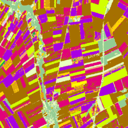
European crop type maps based on Sentinel-1 and LUCAS Copernicus 2018 in-situ observations for 2018, and a combination of Sentinel-1, Sentinel-2, and auxiliary data with LUCAS Copernicus 2022 observations for 2022. Based on the unique LUCAS 2018 Copernicus in-situ survey, this dataset represents the first … agriculture crop eu jrc lucas sentinel1-derived -
LUCAS Copernicus (Polygons with attributes, 2018) V1
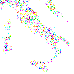
The Land Use/Cover Area frame Survey (LUCAS) in the European Union (EU) was set up to provide statistical information. It represents a triennial in-situ landcover and land-use data-collection exercise that extends over the whole of the EU's territory. LUCAS collects information on land cover and … copernicus eu jrc landcover landuse landuse-landcover -
LUCAS Harmonized (Theoretical Location, 2006-2018) V1
The Land Use/Cover Area frame Survey (LUCAS) in the European Union (EU) was set up to provide statistical information. It represents a triennial in-situ landcover and land-use data-collection exercise that extends over the whole of the EU's territory. LUCAS collects information on land cover and … eu jrc landcover landuse landuse-landcover lucas -
LUCAS THLOC (Points with attributes, 2022) V1

The Land Use/Cover Area frame Survey (LUCAS) in the European Union (EU) was set up to provide statistical information. It represents a triennial in-situ landcover and land-use data-collection exercise that extends over the whole of the EU's territory. LUCAS collects information on land cover and … eu jrc landcover landuse landuse-landcover lucas