Page Summary
-
The 2000 Greenland Mosaic is a 15m resolution image dataset derived from Landsat 7 and RADARSAT-1 imagery from 1999-2002.
-
The CryoSat-2 Antarctica 1km DEM is a digital elevation model of the Antarctic ice sheet and shelves based on CryoSat-2 satellite data from 2010-2016.
-
The Greenland DEM (GIMP) combines ASTER, SPOT-5 DEMs, and AVHRR photoclinometry for different areas of the Greenland ice sheet.
-
The Greenland Ice & Ocean Mask provides 15m resolution land ice and ocean classifications for the Greenland ice sheet using Landsat 7 imagery.
-
The MEaSUREs Greenland Ice Velocity dataset provides mean monthly velocity maps for selected Greenland glacier outlet areas from optical images.
-
2000 Greenland Mosaic - Greenland Ice Mapping Project (GIMP)
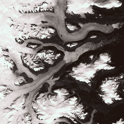
This dataset provides a complete 15 m resolution image mosaic of the Greenland ice sheet derived from Landsat 7 ETM+ and RADARSAT-1 SAR imagery from the years 1999 to 2002. The methods include a combination of image cloud masking, pan sharpening, image sampling and resizing, … arctic gimp greenland imagery nasa polar -
CryoSat-2 Antarctica 1km DEM
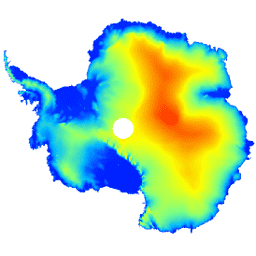
This dataset is a digital elevation model (DEM) of the Antarctic ice sheet and ice shelves based on observations recorded by the CryoSat-2 satellite radar altimeter between July 2010 and July 2016. The DEM is formed from spatio-temporal fits to elevation measurements accumulated within 1, … antarctica dem elevation elevation-topography polar -
Greenland DEM - Greenland Mapping Project (GIMP)
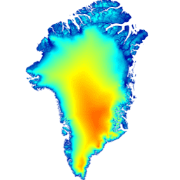
This Digital Elevation Model (DEM) is constructed from a combination of ASTER and SPOT-5 DEM's for the ice sheet periphery and margin (i.e. below the equilbrium line elevation) south of approximately 82.5°N and AVHRR photoclinometry in the ice sheet interior and far north (Scambos and … arctic elevation-topography gimp greenland nasa polar -
Greenland Ice & Ocean Mask - Greenland Mapping Project (GIMP)
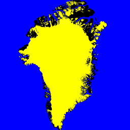
This dataset provides complete land ice and ocean classification masks at 15 m for the Greenland ice sheet. Ice cover was mapped using a combination of orthorectified panchromatic (band 8) imagery from the Landsat 7 Enhanced Thematic Mapper Plus (ETM+), distributed by the USGS, and … arctic cryosphere gimp greenland ice nasa -
MEaSUREs Greenland Ice Velocity: Selected Glacier Site Velocity Maps from Optical Images Version 2
This dataset, part of the NASA Making Earth System Data Records for Use in Research Environments (MEaSUREs) program, consists of mean monthly velocity maps for selected glacier outlet areas. The maps are generated by tracking visible features between optical image pairs acquired by the Landsat … arctic cryosphere gimp greenland ice nasa