Page Summary
-
Enhanced Vegetation Index (EVI) products from the Malaria Atlas Project provide gap-filled data derived from MODIS imagery at 8-daily, annual, and monthly intervals with 1km resolution.
-
The MCD12Q2.006 product offers global land surface phenology metrics yearly at 500m resolution using a 2-band Enhanced Vegetation Index.
-
Several MODIS V6.1 products (MOD13 and MYD13) provide both Normalized Difference Vegetation Index (NDVI) and Enhanced Vegetation Index (EVI) globally at 16-day and monthly intervals with varying resolutions (250m, 500m, 1km).
-
The VNP13A1.002 product from VIIRS provides vegetation indices, including EVI and NDVI, every 16 days at 500m resolution.
-
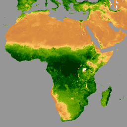
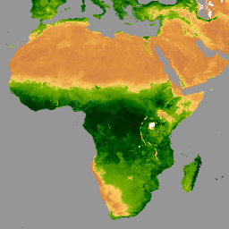
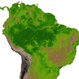
EVI: Malaria Atlas Project Gap-Filled Enhanced Vegetation Index (8-Daily 1km)
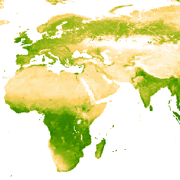
The underlying dataset for this Enhanced Vegetation Index (EVI) product is MODIS BRDF-corrected imagery (MCD43B4), which was gap-filled using the approach outlined in Weiss et al. (2014) to eliminate missing data caused by factors such as cloud cover. After gap-filling the data was clipped to … evi malariaatlasproject map publisher-dataset vegetation vegetation-indices -
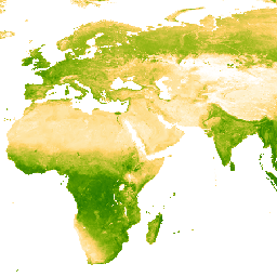
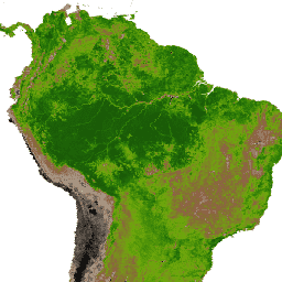
EVI: Malaria Atlas Project Gap-Filled Enhanced Vegetation Index (Annual 1km)

The underlying dataset for this Enhanced Vegetation Index (EVI) product is MODIS BRDF-corrected imagery (MCD43B4), which was gap-filled using the approach outlined in Weiss et al. (2014) to eliminate missing data caused by factors such as cloud cover. After gap-filling the data was clipped to … evi malariaatlasproject map publisher-dataset vegetation vegetation-indices -
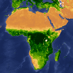
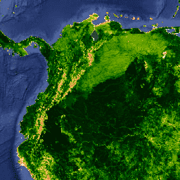
EVI: Malaria Atlas Project Gap-Filled Enhanced Vegetation Index (Monthly 1km)
The underlying dataset for this Enhanced Vegetation Index (EVI) product is MODIS BRDF-corrected imagery (MCD43B4), which was gap-filled using the approach outlined in Weiss et al. (2014) to eliminate missing data caused by factors such as cloud cover. After gap-filling the data was clipped to … evi malariaatlasproject map publisher-dataset vegetation vegetation-indices -
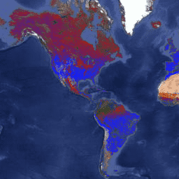
Landsat Collection 2 Tier 1 Level 2 8-Day EVI Composite

These Landsat Collection 2 Tier 1 Level 2 composites are made from Tier 1 Level 2 orthorectified scenes. The Enhanced Vegetation Index (EVI) is generated from the Near-IR, Red and Blue bands of each scene, and ranges in value from -1.0 to 1.0. See Huete … evi landsat landsat-composite usgs vegetation vegetation-indices -
Landsat Collection 2 Tier 1 Level 2 Annual EVI Composite

These Landsat Collection 2 Tier 1 Level 2 composites are made from Tier 1 Level 2 orthorectified scenes. The Enhanced Vegetation Index (EVI) is generated from the Near-IR, Red and Blue bands of each scene, and ranges in value from -1.0 to 1.0. See Huete … evi landsat landsat-composite usgs vegetation vegetation-indices -
MCD12Q2.006 Land Cover Dynamics Yearly Global 500m
The Terra and Aqua combined Moderate Resolution Imaging Spectroradiometer (MODIS) Land Cover Dynamics (MCD12Q2) Version 6.1 data product provides global land surface phenology metrics at yearly intervals. The MCD12Q2 Version 6.1 data product is derived from time series of the 2-band Enhanced Vegetation Index (EVI2) … evi global landuse-landcover modis onset-greenness phenology -
MOD13A1.061 Terra Vegetation Indices 16-Day Global 500m

The MOD13A1 V6.1 product provides a Vegetation Index (VI) value at a per pixel basis. There are two primary vegetation layers. The first is the Normalized Difference Vegetation Index (NDVI) which is referred to as the continuity index to the existing National Oceanic and Atmospheric … 16-day evi global modis nasa ndvi -
MOD13A2.061 Terra Vegetation Indices 16-Day Global 1km
The MOD13A2 V6.1 product provides two Vegetation Indices (VI): the Normalized Difference Vegetation Index (NDVI) and the Enhanced Vegetation Index (EVI). The NDVI is referred to as the continuity index to the existing National Oceanic and Atmospheric Administration-Advanced Very High Resolution Radiometer (NOAA-AVHRR) derived NDVI. … 16-day evi global modis nasa ndvi -
MOD13A3.061 Vegetation Indices Monthly L3 Global 1 km SIN Grid
The MOD13A3 V6.1 product data is provided monthly at 1 kilometer (km) spatial resolution. In generating this monthly product, the algorithm ingests all the MOD13A2 products that overlap the month and employs a weighted temporal average. Vegetation indices are used for global monitoring of vegetation … evi global modis monthly nasa ndvi -
MOD13Q1.061 Terra Vegetation Indices 16-Day Global 250m
The MOD13Q1 V6.1 product provides a Vegetation Index (VI) value at a per pixel basis. There are two primary vegetation layers. The first is the Normalized Difference Vegetation Index (NDVI) which is referred to as the continuity index to the existing National Oceanic and Atmospheric … 16-day evi global modis nasa ndvi -
MYD13A1.061 Aqua Vegetation Indices 16-Day Global 500m
The MYD13A1 V6.1 product provides a Vegetation Index (VI) value at a per pixel basis. There are two primary vegetation layers. The first is the Normalized Difference Vegetation Index (NDVI) which is referred to as the continuity index to the existing National Oceanic and Atmospheric … 16-day aqua evi global modis nasa -
MYD13A2.061 Aqua Vegetation Indices 16-Day Global 1km

The MYD13A2 V6.1 product provides two Vegetation Indices (VI): the Normalized Difference Vegetation Index (NDVI) and the Enhanced Vegetation Index (EVI). The NDVI is referred to as the continuity index to the existing National Oceanic and Atmospheric Administration-Advanced Very High Resolution Radiometer (NOAA-AVHRR) derived NDVI. … 16-day aqua evi global modis nasa -
MYD13A3.061 Aqua Vegetation Indices Monthly L3 Global 1 km SIN Grid
The Aqua Moderate Resolution Imaging Spectroradiometer (MODIS) Vegetation Indices (MYD13A3) Version 6.1 data are provided monthly at 1 kilometer (km) spatial resolution as a gridded Level 3 product in the sinusoidal projection. In generating this monthly product, the algorithm ingests all the MYD13A2 products that … aqua evi global modis monthly nasa -
MYD13Q1.061 Aqua Vegetation Indices 16-Day Global 250m
The MYD13Q1 V6.1 product provides a Vegetation Index (VI) value at a per pixel basis. There are two primary vegetation layers. The first is the Normalized Difference Vegetation Index (NDVI) which is referred to as the continuity index to the existing National Oceanic and Atmospheric … 16-day aqua evi global modis nasa -
VNP13A1.002: VIIRS Vegetation Indices 16-Day 500m
The Suomi National Polar-Orbiting Partnership (S-NPP) NASA Visible Infrared Imaging Radiometer Suite (VIIRS) Vegetation Indices (VNP13A1) data product provides vegetation indices by a process of selecting the best available pixel over a 16-day acquisition period at 500 meter resolution. The VNP13 data products are designed … 16-day evi nasa ndvi noaa npp