Page Summary
-
The Cote d'Ivoire BNETD 2020 Land Cover Map provides land cover data produced by the Ivorian Government with support from the European Union.
-
The Global 2020 Forest Classification provides classes of global forests at approximately 30m resolution to support aboveground biomass estimates.
-
Global PALSAR-2/PALSAR Forest/Non-Forest Maps classify SAR images to distinguish between forest and non-forest areas at 25m resolution.
-
Cote d'Ivoire BNETD 2020 Land Cover Map
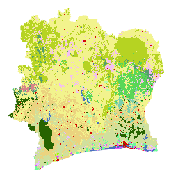
The Cote d'Ivoire BNETD 2020 Land Cover Map was produced by the Ivorian Government through a national institution, the Center for Geographic Information and Digital from the National Study Office Techniques and Development (BNETD-CIGN), with technical and financial support from the European Union. The methodology … classification deforestation forest landcover landuse-landcover -
Global 2020 Forest Classification for IPCC Aboveground Biomass Tier 1 Estimates, V1
This dataset provides classes of global forests delineated by status/condition in 2020 at approximately 30m resolution. The data support generating Tier 1 estimates for Aboveground dry woody Biomass Density (AGBD) in natural forests in the 2019 Refinement to the 2006 IPCC Guidelines for National Greenhouse … aboveground biomass carbon classification forest forest-biomass -
Global 3-class PALSAR-2/PALSAR Forest/Non-Forest Map
A newer version of this dataset with 4 classes for 2017-2020 can be found in JAXA/ALOS/PALSAR/YEARLY/FNF4 The global forest/non-forest map (FNF) is generated by classifying the SAR image (backscattering coefficient) in the global 25m resolution PALSAR-2/PALSAR SAR mosaic so that strong and low backscatter pixels … alos alos2 classification eroc forest forest-biomass -
Global 4-class PALSAR-2/PALSAR Forest/Non-Forest Map

The global forest/non-forest map (FNF) is generated by classifying the SAR image (backscattering coefficient) in the global 25m resolution PALSAR-2/PALSAR SAR mosaic so that strong and low backscatter pixels are assigned as "forest" and "non-forest", respectively. Here, "forest" is defined as the natural forest with … alos alos2 classification eroc forest forest-biomass